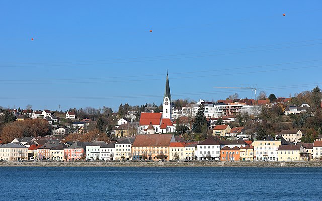
Санкт-Панталеон-Эрла (Sankt Pantaleon-Erla, St. Pantaleon-Erla)
 Hiking in Санкт-Панталеон-Эрла
Sankt Pantaleon-Erla is a picturesque area in Austria known for its beautiful landscapes and outdoor activities, including hiking. Nestled amidst rolling hills and lush greenery, it offers various trails that cater to hikers of different skill levels.
Popular Hiking Trails
-
Local Nature Trails: The region features numerous well-marked trails that can take you through forests, meadows, and along rivers. These paths often vary in difficulty, allowing both beginners and experienced hikers to enjoy the scenery.
-
Panoramic Routes: Some trails lead to higher elevations, rewarding hikers with stunning panoramic views of the surrounding countryside and the nearby Alps.
-
Cultural Routes: Certain trails offer opportunities to explore the rich history of the area, including local churches, historical sites, and traditional farms.
Tips for Hiking in Sankt Pantaleon-Erla
-
Maps and Guides: Always carry a detailed map or a guidebook of the area. Many trails are well-marked, but it's good to have a reference.
-
Weather Preparedness: The weather can change quickly in the mountains, so check the forecast before heading out, and dress in layers.
-
Safety: Ensure you have adequate supplies, including water, snacks, and a first aid kit. Inform someone of your hiking plans.
-
Respect Nature: Follow the Leave No Trace principles to keep the hiking trails clean and protect the natural environment.
Best Time to Hike
The most favorable time for hiking in Sankt Pantaleon-Erla is generally late spring through early autumn, when the weather is mild and the trails are dry. However, winter hiking can also be beautiful, provided you’re equipped for snow and cold conditions.
Additional Activities
In addition to hiking, the area offers opportunities for cycling, bird-watching, and enjoying local cuisine in nearby towns and villages. After a day on the trails, you can relax in the cozy local restaurants, sampling traditional Austrian dishes.
Overall, Sankt Pantaleon-Erla is a wonderful destination for nature lovers and outdoor enthusiasts looking to explore Austria's beautiful landscapes.
- Страна:

- Почтовый код: 4303
- Телефонный код: 07435
- Код автомобильного номера: AM
- Координаты: 48° 11' 57" N, 14° 34' 17" E


- GPS треки (wikiloc): [Ссылка]
- Высота над уровнем моря: 242 м m
- Площадь: 28.38 кв.км
- Население: 2587
- Веб сайт: http://www.st-pantaleon-erla.gv.at/
- Википедия русская: wiki(ru)
- Википедия английская: wiki(en)
- Википедия национальная: wiki(de)
- Хранилище Wikidata: Wikidata: Q661826
- Катеория в википедии: [Ссылка]
- код Freebase: [/m/02qsqsw]
- код GeoNames: Альт: [7871697]
- код VIAF: Альт: [240563422]
- код австрийского муниципалитета: [30529]
Граничит с регионами:

Энс
- город в Федеральной земле Верхняя Австрия
Hiking in Энс
Enns, a town in Austria, is situated in the stunning region of Upper Austria and is known for its rich history and beautiful landscapes. While it may not be as prominent as some larger tourist destinations, it offers a fantastic opportunity for hiking and enjoying nature in a more tranquil setting. Here are some aspects to consider if you're interested in hiking around Enns:...
- Страна:
- Почтовый код: 4470
- Телефонный код: 07223
- Код автомобильного номера: LL
- Координаты: 48° 13' 0" N, 14° 28' 30" E
- GPS треки (wikiloc): [Ссылка]
- Высота над уровнем моря: 281 м m
- Площадь: 33.27 кв.км
- Население: 11523
- Веб сайт: [Ссылка]
Маутхаузен
Hiking in Маутхаузен
Mauthausen, located in Austria, is best known for its historical significance due to the former concentration camp situated nearby. However, the region also offers beautiful hiking opportunities, particularly for those looking to explore the scenic landscapes of Upper Austria....
- Страна:
- Почтовый код: 4310
- Телефонный код: 07238
- Код автомобильного номера: PE
- Координаты: 48° 14' 31" N, 14° 31' 1" E
- GPS треки (wikiloc): [Ссылка]
- Высота над уровнем моря: 265 м m
- Площадь: 14.03 кв.км
- Население: 4936
- Веб сайт: [Ссылка]
Санкт-Фалентин
Hiking in Санкт-Фалентин
St. Valentin, located in the province of South Tyrol in northern Italy, offers a variety of hiking opportunities that cater to different skill levels and preferences. Nestled in the scenic Val d’Isarco, St. Valentin is surrounded by lush landscapes and beautiful mountain scenery. Here are some key points about hiking in the area:...
- Страна:
- Телефонный код: 07435
- Код автомобильного номера: AM
- Координаты: 48° 10' 29" N, 14° 32' 0" E
- GPS треки (wikiloc): [Ссылка]
- Высота над уровнем моря: 272 м m
- Площадь: 45.64 кв.км
- Население: 9340
- Веб сайт: [Ссылка]

Нарн-им-Махланде
Hiking in Нарн-им-Махланде
Naarn im Machlande, located in Austria, is not as widely known as some of the country's larger hiking destinations, but it offers a charming experience for those looking to explore the scenic beauty of the region. The area is characterized by its gentle rolling hills, lush fields, and picturesque landscapes, making it suitable for amateur and experienced hikers alike....
- Страна:
- Почтовый код: 4331
- Телефонный код: 07262
- Код автомобильного номера: PE
- Координаты: 48° 13' 36" N, 14° 36' 32" E
- GPS треки (wikiloc): [Ссылка]
- Высота над уровнем моря: 245 м m
- Площадь: 35.17 кв.км
- Население: 3690
- Веб сайт: [Ссылка]
Штренгберг
Hiking in Штренгберг
Strengberg, located in Upper Austria, offers a variety of hiking opportunities for outdoor enthusiasts. The scenic landscape is characterized by rolling hills, forests, and beautiful views of the surrounding countryside. Here are some key points to consider for hiking in Strengberg:...
- Страна:
- Почтовый код: 3314
- Телефонный код: 07432
- Код автомобильного номера: AM
- Координаты: 48° 8' 36" N, 14° 39' 2" E
- GPS треки (wikiloc): [Ссылка]
- Высота над уровнем моря: 358 м m
- Площадь: 36.81 кв.км
- Население: 2055
- Веб сайт: [Ссылка]
Энсдорф
Hiking in Энсдорф
Ennsdorf, located near the Enns River in Austria, is surrounded by beautiful natural landscapes that make it an excellent destination for hiking enthusiasts. Here are some highlights and tips for hiking in and around Ennsdorf:...
- Страна:
- Почтовый код: 4482
- Телефонный код: 07223
- Код автомобильного номера: AM
- Координаты: 48° 12' 45" N, 14° 29' 21" E
- GPS треки (wikiloc): [Ссылка]
- Высота над уровнем моря: 250 м m
- Площадь: 7.69 кв.км
- Население: 3031
- Веб сайт: [Ссылка]