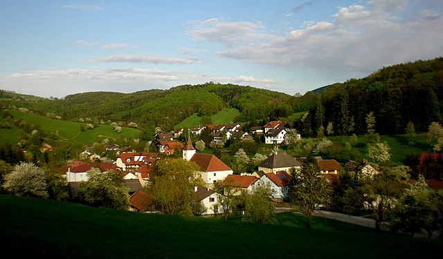
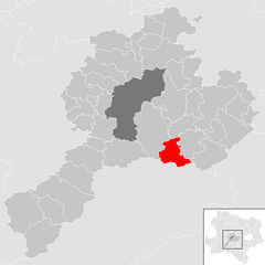
Санкт-Файт-ан-дер-Гёльзен (Sankt Veit an der Gölsen, St. Veit an der Gölsen)
 Hiking in Санкт-Файт-ан-дер-Гёльзен
Sankt Veit an der Gölsen, located in Lower Austria, offers a variety of hiking opportunities set against beautiful landscapes, including rolling hills, forests, and picturesque views. Here are some key points for hiking in this area:
Popular Hiking Trails:
-
Gölsentalweg: This scenic trail follows the Gölsen River and showcases the natural beauty of the region. It's suitable for various skill levels and provides opportunities for leisurely walks as well as more challenging hikes.
-
Schoberstein: A hike to Schoberstein offers rewarding views of the surrounding valleys and hills. The trail is well-marked and is a great option for day hikes.
-
Local Forest Trails: The area is surrounded by dense forests that feature several well-maintained trails. These trails are perfect for nature enthusiasts looking to enjoy the peace of the woods.
Preparation and Tips:
-
Best Time to Hike: The best hiking seasons are typically late spring through early fall. During autumn, the foliage offers stunning views, but be cautious of wet and slippery trails.
-
Gear: Good hiking boots are essential due to mixed terrain, and don’t forget to pack water, snacks, and a map or GPS device.
-
Weather: It's essential to check the weather beforehand, as conditions can change rapidly in mountainous areas.
-
Local Guidelines: Follow local trails guidelines and regulations, as some areas may have specific rules for hikers.
Additional Activities:
Aside from hiking, Sankt Veit an der Gölsen is near other recreational activities such as cycling, nature walks, and exploring local wildlife. You can also visit nearby towns and enjoy regional cuisine.
Overall, Sankt Veit an der Gölsen presents a wonderful hiking experience for both beginners and seasoned hikers looking to explore the beauty of Lower Austria.
- Страна:

- Почтовый код: 3161
- Телефонный код: 02763
- Код автомобильного номера: LF
- Координаты: 48° 2' 0" N, 15° 40' 0" E


- GPS треки (wikiloc): [Ссылка]
- Высота над уровнем моря: 369 м m
- Площадь: 78.14 кв.км
- Население: 3915
- Веб сайт: http://www.st-veit-goelsen.gv.at
- Википедия русская: wiki(ru)
- Википедия английская: wiki(en)
- Википедия национальная: wiki(de)
- Хранилище Wikidata: Wikidata: Q675229
- Катеория в википедии: [Ссылка]
- код Freebase: [/m/02qxqz4]
- код GeoNames: Альт: [7871811]
- код VIAF: Альт: [248681503]
- идентификатор местоположения ArchINFORM: [15890]
- код австрийского муниципалитета: [31412]
Граничит с регионами:

Вильгельмсбург
Hiking in Вильгельмсбург
Wilhelmsburg, a municipality in the district of Sankt Pölten-Land in Lower Austria, offers a charming backdrop for hiking enthusiasts. Nestled near the Traisen River and surrounded by beautiful countryside, it presents a mix of scenic trails and rural landscapes that cater to hikers of all levels....
- Страна:
- Почтовый код: 3150
- Телефонный код: 0 27 46
- Код автомобильного номера: PL
- Координаты: 48° 6' 39" N, 15° 36' 36" E
- GPS треки (wikiloc): [Ссылка]
- Высота над уровнем моря: 321 м m
- Площадь: 45.76 кв.км
- Население: 6557
- Веб сайт: [Ссылка]

Хайнфельд
Hiking in Хайнфельд
Hainfeld, located in Lower Austria, is surrounded by picturesque landscapes, making it a great destination for hiking enthusiasts. The area offers various trails that cater to different skill levels, from easy walks through lush forests to more challenging hikes with steep ascents....
- Страна:
- Почтовый код: 3170
- Телефонный код: 02764
- Код автомобильного номера: LF
- Координаты: 48° 2' 0" N, 15° 46' 0" E
- GPS треки (wikiloc): [Ссылка]
- Высота над уровнем моря: 439 м m
- Площадь: 44.73 кв.км
- Население: 3726
- Веб сайт: [Ссылка]
Пира
Hiking in Пира
Pyhra is a small town in Austria, located in the lower part of the country, close to the scenic landscapes of the Alps. While it may not be as widely known as some of the larger tourist destinations in Austria, it offers a wealth of opportunities for hiking enthusiasts....
- Страна:
- Почтовый код: 3143
- Телефонный код: 02745
- Код автомобильного номера: PL
- Координаты: 48° 9' 0" N, 15° 41' 0" E
- GPS треки (wikiloc): [Ссылка]
- Высота над уровнем моря: 298 м m
- Площадь: 66.76 кв.км
- Население: 3553
- Веб сайт: [Ссылка]
Клайнцелль
Hiking in Клайнцелль
Kleinzell is a picturesque area located in Austria, known for its scenic landscapes and outdoor activities, including hiking. The region offers a variety of trails suitable for different skill levels, making it a great destination for both novice and experienced hikers....
- Страна:
- Почтовый код: 3171
- Телефонный код: 02766
- Код автомобильного номера: LF
- Координаты: 47° 59' 0" N, 15° 45' 0" E
- GPS треки (wikiloc): [Ссылка]
- Высота над уровнем моря: 480 м m
- Площадь: 93.02 кв.км
- Население: 831
- Веб сайт: [Ссылка]
Эшенау
Hiking in Эшенау
Eschenau, located in the scenic region of Bavaria, Germany, offers several hiking opportunities that highlight the area's natural beauty and cultural heritage....
- Страна:
- Почтовый код: 3153
- Телефонный код: 02762
- Код автомобильного номера: LF
- Координаты: 48° 2' 0" N, 15° 34' 0" E
- GPS треки (wikiloc): [Ссылка]
- Высота над уровнем моря: 406 м m
- Площадь: 24.71 кв.км
- Население: 1306
- Веб сайт: [Ссылка]
Михельбах
- община в Австрии, Нижняя Австрия, Санкт-Пёльтен
Hiking in Михельбах
Michelbach is a picturesque area in Lower Austria known for its beautiful landscapes, rolling hills, and access to various hiking trails that offer both beginners and experienced hikers opportunities to enjoy nature....
- Страна:
- Почтовый код: 3074
- Телефонный код: 02744
- Код автомобильного номера: PL
- Координаты: 48° 5' 0" N, 15° 45' 0" E
- GPS треки (wikiloc): [Ссылка]
- Высота над уровнем моря: 376 м m
- Площадь: 24.95 кв.км
- Население: 915
- Веб сайт: [Ссылка]
Трайзен
Hiking in Трайзен
Traisen, a picturesque village in Austria, is surrounded by the lush landscapes of the Lower Austria region, making it a great spot for hiking enthusiasts. Here are some aspects to consider when planning a hiking trip in and around Traisen:...
- Страна:
- Почтовый код: 3160
- Телефонный код: 02762
- Код автомобильного номера: LF
- Координаты: 48° 2' 38" N, 15° 36' 32" E
- GPS треки (wikiloc): [Ссылка]
- Высота над уровнем моря: 356 м m
- Площадь: 6.79 кв.км
- Население: 3453
- Веб сайт: [Ссылка]
Рорбах-ан-дер-Гёльзен
Hiking in Рорбах-ан-дер-Гёльзен
Rohrbach an der Gölsen, a charming village located in Lower Austria, offers beautiful hiking opportunities with scenic views and diverse landscapes. The area is characterized by its rolling hills, lush forests, and the Gölsen river, making it an ideal spot for outdoor enthusiasts....
- Страна:
- Почтовый код: 3163
- Телефонный код: 02764
- Код автомобильного номера: LF
- Координаты: 48° 2' 53" N, 15° 44' 30" E
- GPS треки (wikiloc): [Ссылка]
- Высота над уровнем моря: 402 м m
- Площадь: 14.77 кв.км
- Население: 1556
- Веб сайт: [Ссылка]

Лилиенфельд
Hiking in Лилиенфельд
Lilienfeld is located in Austria, surrounded by stunning natural landscapes and offering various hiking opportunities. The region is characterized by its beautiful forests, rolling hills, alpine meadows, and scenic views of the surrounding mountains....
- Страна:
- Почтовый код: 3180
- Телефонный код: 02762
- Код автомобильного номера: LF
- Координаты: 48° 1' 0" N, 15° 36' 0" E
- GPS треки (wikiloc): [Ссылка]
- Высота над уровнем моря: 383 м m
- Площадь: 53.95 кв.км
- Население: 2833
- Веб сайт: [Ссылка]