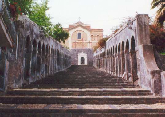
Санта-Мария-ди-Ликодия (Santa Maria di Licodia, Santa Maria di Licodia)
- коммуна в Италии
 Hiking in Санта-Мария-ди-Ликодия
Santa Maria di Licodia is a charming town located on the eastern slopes of Mount Etna in Sicily, Italy. The area is rich in natural beauty and offers several excellent hiking opportunities, especially for those interested in volcanic landscapes and varied terrain.
Hiking Highlights:
-
Mount Etna:
- Volcanic Trails: The proximity to Mount Etna makes Santa Maria di Licodia an ideal base for hiking in the park. There are a variety of trails that cater to different skill levels, from easy walks to challenging hikes leading up to craters and views of the surrounding landscapes.
- Guided Tours: Consider joining a guided hike. Local guides can provide insights into the geology, flora, and fauna of the region, as well as the history of volcanic activity.
-
Sentiero della Lavica (Lava Trail):
- This scenic trail runs through ancient lava flows and offers stunning views of both the volcano and the surrounding countryside. It’s a great way to experience the unique volcanic landscape up close.
-
Natural Reserves:
- Explore nearby nature reserves such as the Parco dell’Etna, which features diverse ecosystems and rich biodiversity. There are numerous trails leading through forests, across fields of lava, and to panoramic viewpoints.
-
Cultural Attractions:
- While hiking, you can also experience the local culture by visiting historical sites and enjoying traditional Sicilian cuisine in the local trattorias. Plan to take breaks to appreciate the natural beauty and local culture.
Tips for Hiking in Santa Maria di Licodia:
- Weather Considerations: Be sure to check the weather conditions before heading out. The climate around Mount Etna can change rapidly, and it's important to be prepared for varying conditions.
- Proper Gear: Wear appropriate hiking boots, carry sufficient water, and pack snacks. A trekking pole may also be helpful on uneven terrain.
- Safety First: When hiking in volcanic areas, pay attention to safety guidelines related to active volcanic sites. Stay on marked trails and follow any regulations set by the park authorities.
- Time Your Hike: Plan your hikes early in the day or later in the afternoon to avoid the midday heat, especially in summer.
Accessibility:
Santa Maria di Licodia itself is well-connected to major highways, making it easy to reach from Catania and other parts of Sicily. Once in the area, you’ll find that many trailheads are accessible by car.
Hiking in and around Santa Maria di Licodia can be a memorable experience, combining stunning landscapes, rich geology, and cultural encounters in one of Italy's most picturesque regions.
- Страна:

- Почтовый код: 95038
- Телефонный код: 095
- Код автомобильного номера: CT
- Координаты: 37° 37' 0" N, 14° 54' 0" E


- GPS треки (wikiloc): [Ссылка]
- Высота над уровнем моря: 442 м m
- Площадь: 26.28 кв.км
- Население: 7691
- Веб сайт: http://www.comune.santamariadilicodia.ct-egov.it/
- Википедия русская: wiki(ru)
- Википедия английская: wiki(en)
- Википедия национальная: wiki(it)
- Хранилище Wikidata: Wikidata: Q478889
- Катеория в википедии: [Ссылка]
- код Freebase: [/m/0bdvmc]
- код GeoNames: Альт: [6537810]
- код VIAF: Альт: [127804332]
- ID отношения в OpenStreetMap: [39305]
- код GND: Альт: [1083848127]
- код LCNAF: Альт: [n00036842]
- WOEID: [723592]
- код ISTAT: 087047
- кадастровый код Италии: I240
Граничит с регионами:

Бьянкавилла
- коммуна в Италии
Biancavilla is a charming town located in the Sicilian region of Italy, nestled on the slopes of Mount Etna, Europe's highest and most active volcano. The surrounding area offers a diverse range of hiking opportunities suitable for various skill levels, with stunning landscapes, rich biodiversity, and unique geological features. Here’s an overview of what you can expect when hiking in Biancavilla:...
- Страна:

- Почтовый код: 95033
- Телефонный код: 095
- Код автомобильного номера: CT
- Координаты: 37° 38' 43" N, 14° 51' 49" E


- GPS треки (wikiloc): [Ссылка]
- Высота над уровнем моря: 513 м m
- Площадь: 70.28 кв.км
- Население: 23948
- Веб сайт: [Ссылка]


Патерно
- коммуна в Италии
Paternò, located in Sicily, Italy, offers a distinct hiking experience thanks to its beautiful landscapes and proximity to Mount Etna, one of the most active volcanoes in the world. Here are some highlights about hiking in and around Paternò:...
- Страна:

- Почтовый код: 95047
- Телефонный код: 095
- Код автомобильного номера: CT
- Координаты: 37° 34' 0" N, 14° 54' 0" E


- GPS треки (wikiloc): [Ссылка]
- Высота над уровнем моря: 225 м m
- Площадь: 144.68 кв.км
- Население: 47827
- Веб сайт: [Ссылка]
Рагальна
- коммуна в Италии
Ragalna, situated on the slopes of Mount Etna in Sicily, Italy, offers an incredible backdrop for hiking enthusiasts. Nestled amidst lush landscapes and volcanic terrain, it features various trails that cater to different skill levels. Here are some key points to consider for hiking in Ragalna:...
- Страна:

- Почтовый код: 95030
- Телефонный код: 095
- Код автомобильного номера: CT
- Координаты: 37° 38' 0" N, 14° 56' 0" E


- GPS треки (wikiloc): [Ссылка]
- Высота над уровнем моря: 830 м m
- Площадь: 39.53 кв.км
- Население: 3960
- Веб сайт: [Ссылка]
