
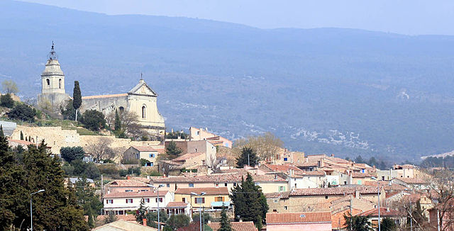
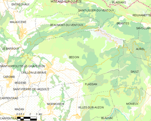
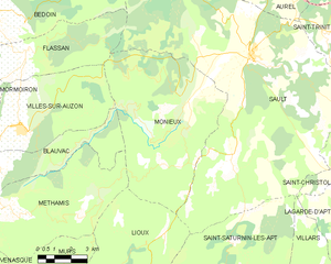
Со (Sault, Sault)

- коммуна во французском департаменте Воклюз
 Hiking in Со
Sault, located in the Vaucluse department of Provence in southeastern France, is a charming village known for its stunning lavender fields, picturesque landscapes, and proximity to the stunning Mont Ventoux. Hiking around Sault offers a blend of natural beauty, cultural experiences, and diverse trails suitable for various skill levels.
Hiking Trails in Sault:
-
Mont Ventoux:
- Description: Often referred to as the "Giant of Provence," Mont Ventoux is a prominent mountain that offers challenging hikes with breathtaking views from the summit. The routes vary in difficulty, and the ascent can be made from different starting points, including Sault itself, which offers a more gradual approach.
- Trail Length: Approximately 16 km (10 miles) round trip.
- Difficulty: Moderate to Challenging.
-
Lavender Routes:
- Description: During the summer months, the lavender fields around Sault are in full bloom. Hiking through these fields provides a sensory experience of beautiful sights and aromatic scents. There are various trails that take you through the best lavender spots.
- Trail Length: Various short circuits, often around 5-10 km (3-6 miles).
- Difficulty: Easy to Moderate.
-
Gorges de la Nesque:
- Description: This scenic gorge is not far from Sault and offers stunning views, rock formations, and diverse wildlife. The hike through the gorge is relatively easy, with some spots offering panoramic viewpoints.
- Trail Length: Approximately 15 km (9 miles) or more, depending on chosen routes.
- Difficulty: Moderate.
-
Sentiers de la Lavande:
- Description: There are marked trails, known as "Sentiers de la Lavande," specifically designed for hiking enthusiasts to explore the lavender-growing regions around Sault. These routes are perfect for families and those looking for leisurely hikes.
- Trail Length: Various loops ranging from 3-10 km (2-6 miles).
- Difficulty: Easy.
Tips for Hiking in Sault:
- Best Time to Visit: The ideal time for hiking in Sault is from late spring to early autumn, especially during the lavender blooming period in July.
- Weather Considerations: Always check the weather forecast as conditions can change rapidly in the mountains. Wear appropriate attire for both warm and cooler conditions.
- Hydration and Snacks: Carry enough water and lightweight snacks, particularly on longer hikes.
- Maps and Navigation: It’s recommended to carry detailed maps or download GPS tracks of the hiking trails before you head out.
- Wildlife and Nature: Be mindful of the local wildlife and flora, and practice Leave No Trace principles to preserve the natural beauty.
Local Attractions:
After your hike, consider exploring the charming village of Sault where you can find local markets, quaint cafés, and restaurants offering delicious Provençal cuisine. Also, if you have time, consider visiting nearby attractions like the beautiful perched village of Montbrun-les-Bains or taking a leisurely drive through the vineyards of the Côtes du Ventoux wine region.
Sault is a fantastic destination for both seasoned hikers and those looking for a more leisurely outdoor experience amidst beautiful landscapes. Enjoy your hiking adventure!
- Страна:

- Почтовый код: 84390
- Координаты: 44° 5' 28" N, 5° 24' 29" E


- GPS треки (wikiloc): [Ссылка]
- Высота над уровнем моря: 760 м m
- Площадь: 111.15 кв.км
- Население: 1363
- Веб сайт: http://www.mairie-sault-84.fr
- Википедия русская: wiki(ru)
- Википедия английская: wiki(en)
- Википедия национальная: wiki(fr)
- Хранилище Wikidata: Wikidata: Q631582
- Катеория в википедии: [Ссылка]
- код Freebase: [/m/03g1tt]
- код GeoNames: Альт: [2975798]
- номер SIREN: [218401230]
- код BNF: [15278103w]
- ID отношения в OpenStreetMap: [181265]
- место в MusicBrainz: [2a49a573-1af7-4cd7-83ef-f00a0425c457]
- код муниципалитета INSEE: 84123
Граничит с регионами:


Сен-Сатюрнен-лез-Апт
- коммуна во Франции
Hiking in Сен-Сатюрнен-лез-Апт
Saint-Saturnin-lès-Apt, located in the Vaucluse department of the Provence region in France, is surrounded by stunning natural landscapes, making it a fantastic location for hiking enthusiasts. The area features picturesque trails that showcase the beautiful scenery of the Luberon Regional Nature Park, including rocky outcrops, vineyards, and charming villages....
- Страна:
- Почтовый код: 84490
- Координаты: 43° 56' 39" N, 5° 23' 2" E
- GPS треки (wikiloc): [Ссылка]
- Высота над уровнем моря: 411 м m
- Площадь: 75.79 кв.км
- Население: 2732
- Веб сайт: [Ссылка]


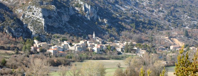
Орель
Hiking in Орель
Aurel is a charming village nestled in the Vaucluse department of Provence, France. The area offers stunning landscapes, rich history, and a variety of trails for hikers of all levels. Here’s an overview of what you can expect when hiking in and around Aurel:...
- Страна:
- Почтовый код: 84390
- Координаты: 44° 7' 46" N, 5° 25' 42" E
- GPS треки (wikiloc): [Ссылка]
- Площадь: 28.9 кв.км
- Население: 207
Бедуан
- коммуна во Франции
Hiking in Бедуан
Bédoin is a picturesque village located at the foot of Mont Ventoux in the Provence region of France, making it a fantastic destination for hiking enthusiasts. Here are some highlights and tips for hiking in Bédoin:...
- Страна:
- Почтовый код: 84410
- Координаты: 44° 7' 24" N, 5° 10' 47" E
- GPS треки (wikiloc): [Ссылка]
- Площадь: 91.03 кв.км
- Население: 3087
- Веб сайт: [Ссылка]


Флассан
- коммуна во Франции
Hiking in Флассан
Flassan is a charming village located in the Vaucluse department in the Provence-Alpes-Côte d'Azur region of southeastern France. Surrounded by beautiful landscapes, it offers various hiking opportunities that showcase the natural beauty of the area....
- Страна:
- Почтовый код: 84410
- Координаты: 44° 5' 56" N, 5° 14' 31" E
- GPS треки (wikiloc): [Ссылка]
- Площадь: 20.6 кв.км
- Население: 444

Сен-Трини
- коммуна во Франции
Hiking in Сен-Трини
Saint-Trinit is a charming village located in the Vaucluse department of the Provence-Alpes-Côte d'Azur region in southeastern France. It is nestled in the beautiful landscapes of Provence, making it a great base for hiking enthusiasts. Here are some aspects to consider when hiking in and around Saint-Trinit:...
- Страна:
- Почтовый код: 84390
- Координаты: 44° 6' 9" N, 5° 27' 57" E
- GPS треки (wikiloc): [Ссылка]
- Площадь: 16.66 кв.км
- Население: 125
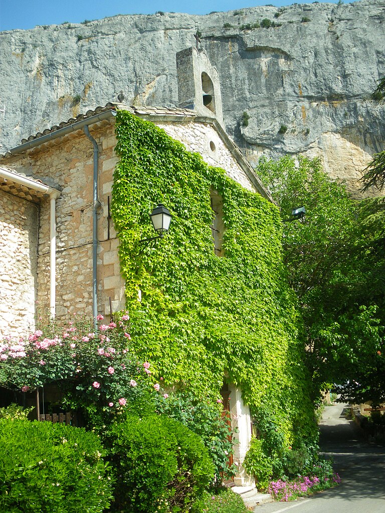
Моньё
- коммуна во Франции
Hiking in Моньё
Monieux is a charming village located in the Vaucluse department of the Provence region in southeastern France. It's surrounded by stunning natural landscapes, making it a great base for hiking enthusiasts....
- Страна:
- Почтовый код: 84390
- Координаты: 44° 4' 2" N, 5° 21' 33" E
- GPS треки (wikiloc): [Ссылка]
- Площадь: 47.12 кв.км
- Население: 372


Сен-Кристоль
Hiking in Сен-Кристоль
Saint-Christol, located in the Vaucluse department of France, is a charming destination for hiking enthusiasts. The region boasts picturesque landscapes, featuring vineyards, rolling hills, and scenic views of the surrounding countryside....
- Страна:
- Почтовый код: 84390
- Координаты: 44° 1' 43" N, 5° 29' 32" E
- GPS треки (wikiloc): [Ссылка]
- Площадь: 46.08 кв.км
- Население: 1348
- Веб сайт: [Ссылка]
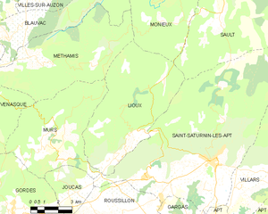
Льу
- коммуна во Франции
Hiking in Льу
Lioux, located in the Vaucluse region of Provence, France, offers stunning landscapes, diverse trails, and picturesque scenery, making it a great destination for hiking enthusiasts. Here are some key highlights and considerations for hiking in Lioux:...
- Страна:
- Почтовый код: 84220
- Координаты: 43° 56' 48" N, 5° 18' 7" E
- GPS треки (wikiloc): [Ссылка]
- Площадь: 38.89 кв.км
- Население: 262