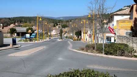
Сен-Сатюрнен-лез-Апт (Saint-Saturnin-lès-Apt, Saint-Saturnin-lès-Apt)

- коммуна во Франции
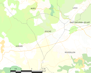
 Hiking in Сен-Сатюрнен-лез-Апт
Saint-Saturnin-lès-Apt, located in the Vaucluse department of the Provence region in France, is surrounded by stunning natural landscapes, making it a fantastic location for hiking enthusiasts. The area features picturesque trails that showcase the beautiful scenery of the Luberon Regional Nature Park, including rocky outcrops, vineyards, and charming villages.
Hiking Trails
- Sentier des Ocres: This trail takes you through the Ochre fields of Roussillon, where you can see stunning red rock formations and unique geological features.
- The Luberon Trail: A long-distance path that traverses the Luberon mountains, offering various segments that can be tackled from Saint-Saturnin-lès-Apt.
- Local Loops: Several shorter loops starting and ending in or near Saint-Saturnin-lès-Apt provide options for beginners and families. These trails often lead through vineyards and olive groves.
Points of Interest
- The Village: Explore the charming streets of Saint-Saturnin-lès-Apt, known for its historical architecture, lovely cafés, and local markets.
- The Castle Ruins: Climb up to the remains of the medieval castle for a panoramic view of the surrounding countryside.
Tips for Hiking
- Best Time to Visit: Spring (April to June) and fall (September to October) offer pleasant weather for hiking and fewer tourists.
- Prepare for Varied Terrain: The trails in this region can vary from gentle slopes to steep climbs. Good hiking shoes are essential.
- Stay Hydrated: Bring plenty of water, especially during the warmer months.
- Respect Nature: Stay on marked trails, take your trash with you, and be mindful of local wildlife.
Local Resources
- Check with local tourism offices for maps and current trail conditions.
- Guides can often be hired if you prefer a more structured experience or want to learn more about the area's flora and fauna.
Hiking in Saint-Saturnin-lès-Apt allows you to immerse yourself in the natural beauty of Provence while enjoying a variety of trail options suitable for all skill levels. Happy hiking!
- Страна:

- Почтовый код: 84490
- Координаты: 43° 56' 39" N, 5° 23' 2" E


- GPS треки (wikiloc): [Ссылка]
- Высота над уровнем моря: 411 м m
- Площадь: 75.79 кв.км
- Население: 2732
- Веб сайт: http://www.saintsaturninlesapt.fr
- Википедия русская: wiki(ru)
- Википедия английская: wiki(en)
- Википедия национальная: wiki(fr)
- Хранилище Wikidata: Wikidata: Q1019156
- Катеория в википедии: [Ссылка]
- код Freebase: [/m/025_vbx]
- номер SIREN: [218401180]
- код BNF: [152780984]
- код VIAF: Альт: [167513388]
- код LCNAF: Альт: [no2008183682]
- код тезауруса PACTOLS: [pcrtQL90oG35TS]
- код муниципалитета INSEE: 84118
Граничит с регионами:

Гаргас
Hiking in Гаргас
Gargas, located in the Vaucluse department of the Provence-Alpes-Côte d'Azur region in southeastern France, is a charming area known for its picturesque landscapes, historical sites, and unique geological features. Hiking in and around Gargas offers a wonderful opportunity to explore the natural beauty of the region, including the iconic ochre cliffs that the area is famous for....
- Страна:
- Почтовый код: 84400
- Координаты: 43° 54' 7" N, 5° 21' 31" E
- GPS треки (wikiloc): [Ссылка]
- Площадь: 14.9 кв.км
- Население: 2976
- Веб сайт: [Ссылка]


Виллар
Hiking in Виллар
Villars, located in the Vaucluse department in the Provence-Alpes-Côte d'Azur region of southeastern France, is a charming village offering some beautiful hiking opportunities surrounded by stunning landscapes....
- Страна:
- Почтовый код: 84400
- Координаты: 43° 55' 24" N, 5° 24' 20" E
- GPS треки (wikiloc): [Ссылка]
- Площадь: 30.05 кв.км
- Население: 774


Апт
- коммуна во Франции
Hiking in Апт
Apt, located in the Vaucluse department of France, is an excellent destination for hiking enthusiasts. Nestled in the heart of the Luberon Regional Park, Apt offers a diverse range of landscapes, from lush hillsides and vineyards to rocky cliffs and scenic viewpoints. Here are some highlights of hiking in and around Apt:...
- Страна:
- Почтовый код: 84400
- Координаты: 43° 52' 34" N, 5° 23' 47" E
- GPS треки (wikiloc): [Ссылка]
- Высота над уровнем моря: 567 м m
- Площадь: 44.57 кв.км
- Население: 11846
- Веб сайт: [Ссылка]

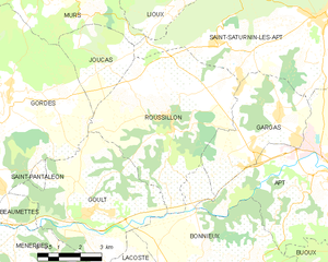
Руссийон
- коммуна во Франции
Hiking in Руссийон
Roussillon, located in the Vaucluse department of the Provence-Alpes-Côte d'Azur region in southeastern France, is renowned for its stunning landscapes, rich ochre deposits, and charming village atmosphere. Hiking in this area offers a unique blend of natural beauty and cultural heritage. Here are some key aspects to consider:...
- Страна:
- Почтовый код: 84220
- Координаты: 43° 54' 8" N, 5° 17' 34" E
- GPS треки (wikiloc): [Ссылка]
- Площадь: 29.77 кв.км
- Население: 1328
- Веб сайт: [Ссылка]


Со
- коммуна во французском департаменте Воклюз
Hiking in Со
Sault, located in the Vaucluse department of Provence in southeastern France, is a charming village known for its stunning lavender fields, picturesque landscapes, and proximity to the stunning Mont Ventoux. Hiking around Sault offers a blend of natural beauty, cultural experiences, and diverse trails suitable for various skill levels....
- Страна:
- Почтовый код: 84390
- Координаты: 44° 5' 28" N, 5° 24' 29" E
- GPS треки (wikiloc): [Ссылка]
- Высота над уровнем моря: 760 м m
- Площадь: 111.15 кв.км
- Население: 1363
- Веб сайт: [Ссылка]


Мюр
Hiking in Мюр
Murs, located in the Vaucluse department of the Provence-Alpes-Côte d'Azur region in southeastern France, is a charming village surrounded by beautiful natural landscapes, making it a fantastic destination for hiking enthusiasts. Here are some key points to consider when planning a hike in and around Murs:...
- Страна:
- Почтовый код: 84220
- Координаты: 43° 57' 7" N, 5° 14' 29" E
- GPS треки (wikiloc): [Ссылка]
- Площадь: 31.27 кв.км
- Население: 419
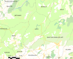
Льу
- коммуна во Франции
Hiking in Льу
Lioux, located in the Vaucluse region of Provence, France, offers stunning landscapes, diverse trails, and picturesque scenery, making it a great destination for hiking enthusiasts. Here are some key highlights and considerations for hiking in Lioux:...
- Страна:
- Почтовый код: 84220
- Координаты: 43° 56' 48" N, 5° 18' 7" E
- GPS треки (wikiloc): [Ссылка]
- Площадь: 38.89 кв.км
- Население: 262

Жукас
- коммуна во Франции
Hiking in Жукас
Joucas is a charming village located in the Provence region of France, known for its picturesque landscapes and scenic views of the Luberon Valley. Hiking in and around Joucas offers a blend of beautiful natural scenery, stunning vistas, and an opportunity to explore local flora and fauna....
- Страна:
- Почтовый код: 84220
- Координаты: 43° 55' 33" N, 5° 15' 8" E
- GPS треки (wikiloc): [Ссылка]
- Площадь: 8.29 кв.км
- Население: 329