Савьоре-делл'Адамелло (Saviore dell'Adamello, Saviore dell'Adamello)
.svg)
- коммуна Италии
 Hiking in Савьоре-делл'Адамелло
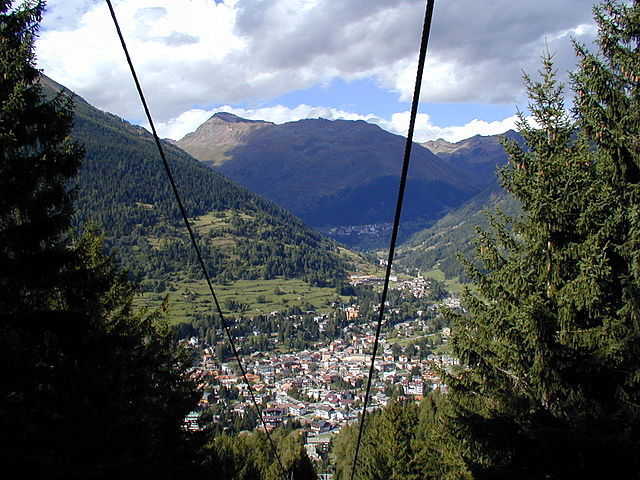
Saviore dell'Adamello is a charming village located in the Italian Alps, specifically in the Lombardy region of Italy. It serves as a gateway to the Adamello-Brenta Natural Park, a stunning area rich in biodiversity, with picturesque landscapes, rugged mountains, crystal-clear lakes, and lush forests, making it a great destination for hiking enthusiasts.
Hiking Opportunities in Saviore dell'Adamello
-
Scenic Trails: The area offers a variety of trails ranging from easy walks to challenging treks, catering to all skill levels. Trails often feature breathtaking views of the surrounding mountains and valleys.
-
Typical Hikes: Some popular hiking routes include:
- Sentiero dei Fiori: A moderate trail that takes hikers through beautiful alpine meadows filled with wildflowers, especially vibrant in spring and summer.
- The Via Alta: A more challenging route that allows hikers to experience stunning panoramic vistas of the Adamello massif. This trail connects various mountain huts where you can stop for rest and refreshments.
-
Lakes and Waterfalls: Hikers can also plan routes that include visits to remote alpine lakes and waterfalls, such as the Lago di Lotto and the Cascate del Rio Vantone, which enhance the natural beauty of the hikes.
-
Wildlife Viewing: The area is home to diverse flora and fauna, including ibex, chamois, and various bird species. Early morning hikes often provide the best opportunities for wildlife watching.
-
Cultural Connection: Besides the natural scenery, hiking trails may lead you to historical sites, ancient hamlets, and pastoral landscapes that reflect the traditional alpine way of life.
Tips for Hiking in Saviore dell'Adamello
- Proper Gear: Ensure you have appropriate hiking gear, including sturdy footwear, weather-resistant clothing, a hat, and sun protection.
- Safety First: Check the weather conditions before heading out and be aware of your physical limits. It's advisable to hike with a partner and carry a detailed map or GPS device.
- Stay Hydrated and Snack: Bring enough water and energy-boosting snacks to keep you fueled during your hike.
- Respect Nature: Follow Leave No Trace principles, stay on marked trails, and be respectful of both wildlife and local communities.
Best Time to Visit
The best time for hiking in Saviore dell'Adamello is typically from late spring to early autumn (May to September). During these months, trails are usually clear of snow, and the weather conditions are milder. However, always check local conditions as they can vary significantly depending on the altitude and specific trail locations.
Saviore dell'Adamello offers a wonderful blend of natural beauty and cultural heritage, making it a fantastic destination for hiking and exploring the great outdoors in the Italian Alps!
- Страна:

- Почтовый код: 25050
- Телефонный код: 0364
- Код автомобильного номера: BS
- Координаты: 46° 4' 50" N, 10° 23' 54" E


- GPS треки (wikiloc): [Ссылка]
- Высота над уровнем моря: 1100 м m
- Площадь: 84.27 кв.км
- Население: 886
- Веб сайт: http://www.comune.saviore-delladamello.bs.it
- Википедия русская: wiki(ru)
- Википедия английская: wiki(en)
- Википедия национальная: wiki(it)
- Хранилище Wikidata: Wikidata: Q111741
- Галерея изображений в википедии: [Ссылка]
- Катеория в википедии: [Ссылка]
- код Freebase: [/m/04d2st]
- код GeoNames: Альт: [6536393]
- ID отношения в OpenStreetMap: [46882]
- код ISTAT: 017175
- кадастровый код Италии: I476
Граничит с регионами:

Чево
- коммуна Италии
Hiking in Чево
Cevo is a charming village located in the Valtellina region of northern Italy, known for its breathtaking landscapes, lush nature, and a variety of hiking opportunities. Here are some key points to consider if you're planning a hiking trip in and around Cevo:...
- Страна:
- Почтовый код: 25040
- Телефонный код: 0364
- Код автомобильного номера: BS
- Координаты: 46° 4' 51" N, 10° 22' 10" E
- GPS треки (wikiloc): [Ссылка]
- Высота над уровнем моря: 1100 м m
- Площадь: 35.47 кв.км
- Население: 865
- Веб сайт: [Ссылка]

Эдоло
- коммуна Италии
Hiking in Эдоло
Edolo is a charming town located in the Brescia province of Lombardy, Italy, surrounded by the stunning landscapes of the Adamello and Tonale mountains. It's an excellent destination for hiking enthusiasts, offering a variety of trails that cater to different skill levels. Here are some highlights of hiking in the Edolo area:...
- Страна:
- Почтовый код: 25048
- Телефонный код: 0364
- Код автомобильного номера: BS
- Координаты: 46° 10' 44" N, 10° 19' 48" E
- GPS треки (wikiloc): [Ссылка]
- Высота над уровнем моря: 720 м m
- Площадь: 88.9 кв.км
- Население: 4564
- Веб сайт: [Ссылка]
Понте-ди-Леньо
- коммуна Италии
Hiking in Понте-ди-Леньо
Ponte di Legno is a beautiful alpine resort located in the Lombardy region of northern Italy, nestled within the stunning landscape of the Adamello-Presanella Natural Park. This area is renowned for its breathtaking mountain scenery, diverse flora and fauna, and a variety of hiking trails suitable for all levels of hikers....
- Страна:
- Почтовый код: 25056
- Телефонный код: 0364
- Код автомобильного номера: BS
- Координаты: 46° 15' 34" N, 10° 30' 34" E
- GPS треки (wikiloc): [Ссылка]
- Высота над уровнем моря: 1258 м m
- Площадь: 100.43 кв.км
- Население: 1730
- Веб сайт: [Ссылка]

Сонико
- коммуна Италии
Hiking in Сонико
Sonico, a charming town in the province of Brescia in Lombardy, is nestled in the picturesque Val Camonica, which offers numerous hiking opportunities for outdoor enthusiasts. The region is known for its stunning landscapes, including mountains, lush valleys, and historical sites, making it a perfect destination for hikers of all levels....
- Страна:
- Почтовый код: 25048
- Телефонный код: 0364
- Код автомобильного номера: BS
- Координаты: 46° 9' 59" N, 10° 21' 14" E
- GPS треки (wikiloc): [Ссылка]
- Высота над уровнем моря: 650 м m
- Площадь: 60.89 кв.км
- Население: 1265
- Веб сайт: [Ссылка]
Спьяццо
- коммуна Италии
Hiking in Спьяццо
Spiazzo is a picturesque village located in the Trentino region of Northern Italy, nestled within the beautiful Val Rendena valley. It offers a variety of hiking opportunities for both casual walkers and experienced trekkers, with trails that range from easy family-friendly paths to more challenging mountain routes....
- Страна:
- Почтовый код: 38088
- Телефонный код: 0465
- Код автомобильного номера: TN
- Координаты: 46° 6' 13" N, 10° 44' 22" E
- GPS треки (wikiloc): [Ссылка]
- Высота над уровнем моря: 649 м m
- Площадь: 71.07 кв.км
- Население: 1260
- Веб сайт: [Ссылка]