
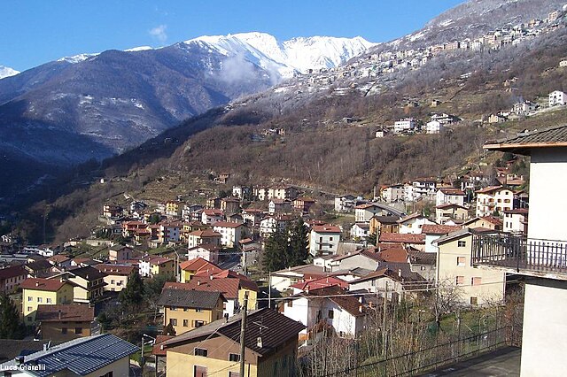
Сонико (Sonico, Lombardy, Sonico)
.svg)
- коммуна Италии
 Hiking in Сонико
Sonico, a charming town in the province of Brescia in Lombardy, is nestled in the picturesque Val Camonica, which offers numerous hiking opportunities for outdoor enthusiasts. The region is known for its stunning landscapes, including mountains, lush valleys, and historical sites, making it a perfect destination for hikers of all levels.
Hiking Trails
-
Sentiero dei Fiori: This scenic trail offers stunning views of the surrounding mountains and valleys, with plenty of wildflowers along the route, especially in spring and summer.
-
Cima di Avio: For more experienced hikers, this trail leads to the summit of Cima di Avio, providing breathtaking panoramas of the neighboring peaks and valleys. The ascent can be challenging but is definitely rewarding.
-
Val di Grigna: A beautiful valley that offers various trails for hikers. You can enjoy the sound of the flowing streams and the sight of waterfalls, along with well-marked paths that cater to different skill levels.
-
Historical Trails: Some trails in the area are well-known for their historical significance, showcasing ancient dwellings and offerings of rock carvings that represent the area's rich history.
Things to Keep in Mind
- Weather and Conditions: Always check the weather conditions before heading out. The weather can change rapidly in mountainous terrain.
- Gear: Wear appropriate footwear (hiking boots recommended) and dress in layers since temperatures can vary throughout the day.
- Maps and Guides: It's wise to carry a map or a GPS device, as some trails might not be well-marked. Consider hiring a local guide if you're unfamiliar with the area.
- Safety: Always inform someone of your hiking plans and expected return time, especially if you’re venturing into remote areas.
Best Time to Hike
The ideal months for hiking in Sonico are generally from late spring through early autumn (May to October), as the weather is milder, and trails are more accessible. Autumn offers stunning foliage, while summer presents the best conditions for longer treks.
Local Culture
Sonico and the surrounding areas offer a rich cultural experience. Don't miss the opportunity to try local dishes that showcase Lombardy's culinary traditions after a rewarding day of hiking.
Overall, hiking in Sonico can be a fantastic way to explore the beauty of Lombardy and enjoy the great outdoors, whether you're looking for leisure strolls or challenging treks.
- Страна:

- Почтовый код: 25048
- Телефонный код: 0364
- Код автомобильного номера: BS
- Координаты: 46° 9' 59" N, 10° 21' 14" E


- GPS треки (wikiloc): [Ссылка]
- Высота над уровнем моря: 650 м m
- Площадь: 60.89 кв.км
- Население: 1265
- Веб сайт: http://www.comune.sonico.bs.it
- Википедия русская: wiki(ru)
- Википедия английская: wiki(en)
- Википедия национальная: wiki(it)
- Хранилище Wikidata: Wikidata: Q112028
- Галерея изображений в википедии: [Ссылка]
- Катеория в википедии: [Ссылка]
- код Freebase: [/m/04d353]
- код GeoNames: Альт: [6537181]
- ID отношения в OpenStreetMap: [46885]
- UN/LOCODE: [ITSOF]
- код Цифрового атласа Римской империи: [17161]
- код ISTAT: 017181
- кадастровый код Италии: I831
Граничит с регионами:
Берцо-Демо
- коммуна Италии
Hiking in Берцо-Демо
Berzo Demo is a charming village located in the province of Brescia in northern Italy, nestled in the Trentini mountains. It's a great spot for those interested in hiking, as it offers a mix of scenic trails and natural beauty. Here are some points to consider when hiking in and around Berzo Demo:...
- Страна:
- Почтовый код: 25040
- Телефонный код: 0364
- Код автомобильного номера: BS
- Координаты: 46° 5' 38" N, 10° 20' 4" E
- GPS треки (wikiloc): [Ссылка]
- Высота над уровнем моря: 785 м m
- Площадь: 15.46 кв.км
- Население: 1638
- Веб сайт: [Ссылка]

Чево
- коммуна Италии
Hiking in Чево
Cevo is a charming village located in the Valtellina region of northern Italy, known for its breathtaking landscapes, lush nature, and a variety of hiking opportunities. Here are some key points to consider if you're planning a hiking trip in and around Cevo:...
- Страна:
- Почтовый код: 25040
- Телефонный код: 0364
- Код автомобильного номера: BS
- Координаты: 46° 4' 51" N, 10° 22' 10" E
- GPS треки (wikiloc): [Ссылка]
- Высота над уровнем моря: 1100 м m
- Площадь: 35.47 кв.км
- Население: 865
- Веб сайт: [Ссылка]

Эдоло
- коммуна Италии
Hiking in Эдоло
Edolo is a charming town located in the Brescia province of Lombardy, Italy, surrounded by the stunning landscapes of the Adamello and Tonale mountains. It's an excellent destination for hiking enthusiasts, offering a variety of trails that cater to different skill levels. Here are some highlights of hiking in the Edolo area:...
- Страна:
- Почтовый код: 25048
- Телефонный код: 0364
- Код автомобильного номера: BS
- Координаты: 46° 10' 44" N, 10° 19' 48" E
- GPS треки (wikiloc): [Ссылка]
- Высота над уровнем моря: 720 м m
- Площадь: 88.9 кв.км
- Население: 4564
- Веб сайт: [Ссылка]

Малонно
- коммуна Италии
Hiking in Малонно
Malonno, located in the beautiful region of Lombardy, Italy, is known for its stunning landscapes and natural beauty, making it a great destination for hiking enthusiasts. Nestled in the Camonica Valley, this area offers a range of trails that cater to different skill levels, from easy walks to more challenging hikes....
- Страна:
- Почтовый код: 25040
- Телефонный код: 0364
- Код автомобильного номера: BS
- Координаты: 46° 7' 0" N, 10° 19' 0" E
- GPS треки (wikiloc): [Ссылка]
- Высота над уровнем моря: 596 м m
- Площадь: 31.46 кв.км
- Население: 3183
- Веб сайт: [Ссылка]

Савьоре-делл'Адамелло
- коммуна Италии
Hiking in Савьоре-делл'Адамелло
Saviore dell'Adamello is a charming village located in the Italian Alps, specifically in the Lombardy region of Italy. It serves as a gateway to the Adamello-Brenta Natural Park, a stunning area rich in biodiversity, with picturesque landscapes, rugged mountains, crystal-clear lakes, and lush forests, making it a great destination for hiking enthusiasts....
- Страна:
- Почтовый код: 25050
- Телефонный код: 0364
- Код автомобильного номера: BS
- Координаты: 46° 4' 50" N, 10° 23' 54" E
- GPS треки (wikiloc): [Ссылка]
- Высота над уровнем моря: 1100 м m
- Площадь: 84.27 кв.км
- Население: 886
- Веб сайт: [Ссылка]