
Шаффхаузен (Schaffhausen, Schaffhausen)

 Hiking in Шаффхаузен
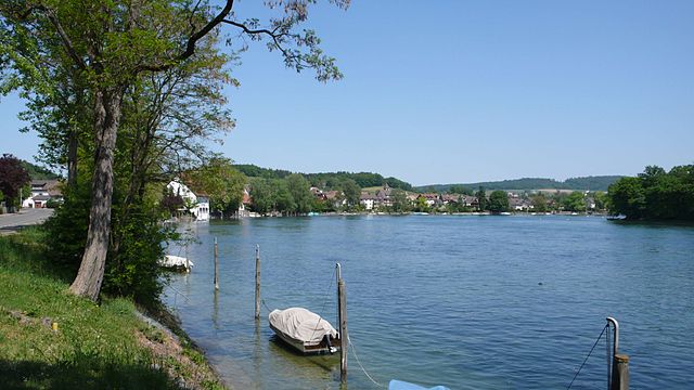
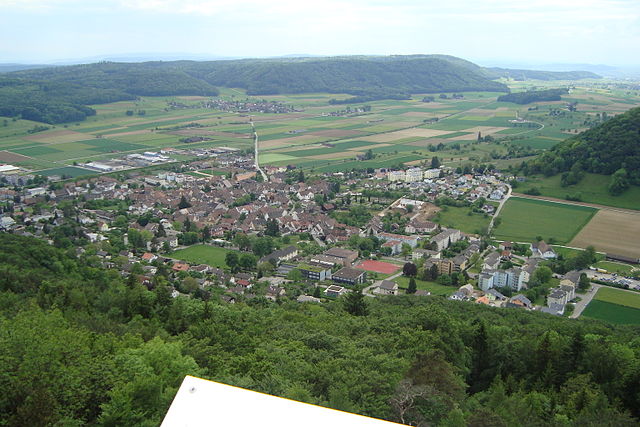
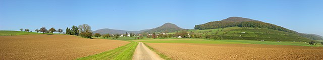
Schaffhausen, located in northeastern Switzerland near the border with Germany, is known for its stunning landscapes, rich history, and picturesque views of the Rhine River. The region offers several excellent hiking opportunities, catering to different skill levels and preferences.
Key Features of Hiking in Schaffhausen:
-
Scenic Trails: The area is dotted with trails that traverse lush forests, vineyards, meadows, and along the shores of the Rhine. Many trails offer breathtaking views of the Rhine Falls, Europe’s largest waterfall, which is a must-see.
-
Rhine Falls: A popular destination for hikers, the Rhine Falls can be explored through various routes that lead to vantage points. The falls themselves are impressive and offer excellent opportunities for photography and nature observation.
-
Historical Significance: Hiking in Schaffhausen also means exploring historical sites. You can find well-preserved medieval towns, castles (like the Munot Fortress), and churches along the way, providing a glimpse into the region's rich history.
-
Vineyards: The vineyards around Schaffhausen produce local wine, particularly noted for its excellent white wine called “Schaffhauser” or “Chasselas.” Some trails take you through these vineyards, allowing for wine-tasting stops along the way.
-
Nature Reserves: Several nature reserves and parks, such as the Höri and the Rhine Valley, offer marked trails for hiking and bird-watching. These areas are rich in flora and fauna and are perfect for those looking to immerse themselves in nature.
-
Hiking Networks: Schaffhausen is part of the extensive Swiss hiking network, which means well-marked trails and access to information about routes and difficulties. You can find everything from easy walks to more challenging hikes in the area.
-
Accessibility: Schaffhausen is easily accessible via public transport, making it convenient for day hikes. The train connects to various trailheads throughout the region.
-
Seasonal Hiking: Each season offers a different experience; spring brings blooming flowers, summer provides lush greenery, autumn showcases beautiful foliage, and winter can transform the landscape into a snowy wonderland.
Tips for Hiking in Schaffhausen:
- Plan Your Route: Determine which trails suit your fitness level and interests. Local tourist information centers can provide maps and guidance.
- Weather Preparedness: Check the weather forecast before heading out. Swiss weather can change rapidly, especially in mountainous areas.
- Bring Essentials: Always carry water, snacks, and a basic first aid kit. Good hiking boots are recommended for comfort and safety.
- Respect Nature: Follow the Leave No Trace principles to preserve the natural beauty of the area.
- Consider Guided Tours: If you’re unfamiliar with the area or want to learn more about its history, consider joining a guided hiking tour.
Overall, hiking in Schaffhausen offers a remarkable blend of natural beauty and cultural experiences, making it a fantastic destination for outdoor enthusiasts.
- Страна:

- Почтовый код: 8231; 8208; 8203; 8201; 8200
- Телефонный код: 052
- Код автомобильного номера: SH
- Координаты: 47° 41' 48" N, 8° 38' 2" E


- GPS треки (wikiloc): [Ссылка]
- Высота над уровнем моря: 518 м m
- Площадь: 41.78 кв.км
- Население: 36148
- Веб сайт: http://www.stadt-schaffhausen.ch
- Википедия русская: wiki(ru)
- Википедия английская: wiki(en)
- Википедия национальная: wiki(de)
- Хранилище Wikidata: Wikidata: Q9009
- Галерея изображений в википедии: [Ссылка]
- Катеория в википедии: [Ссылка]
- Карты в википедии: [Ссылка]
- код Freebase: [/m/017jqc]
- код GeoNames: Альт: [7287070]
- код BNF: [12071302n]
- код VIAF: Альт: [136659461]
- ID отношения в OpenStreetMap: [1683703]
- код GND: Альт: [4051993-4]
- идентификатор местоположения ArchINFORM: [1570]
- код LCNAF: Альт: [n81107043]
- место в MusicBrainz: [57c8393c-11b0-45f4-b99f-85533950107a]
- WOEID: [12683079]
- код темы Quora: [Schaffhausen]
- код в энциклопедии «Британника онлайн»: [place/Schaffhausen-Switzerland]
- идентификатор HDS: [1281]
- EMLO location ID: [d1eb0525-38fb-4ea5-a4c9-124520616991]
- код места в Facebook: [115768388433690]
- код швейцарского муниципалитета: [2939]
- код ISNI: Альт: [0000 0001 0944 0916]
- код статьи Klexikon: [Schaffhausen]
- код GAMEO: [Schaffhausen (Switzerland)]
- код US National Archives: 10045194
Граничит с регионами:

Бюзинген-на-Верхнем-Рейне
Hiking in Бюзинген-на-Верхнем-Рейне
Büsingen am Hochrhein is a unique location, situated in Germany but entirely surrounded by Switzerland. It offers a beautiful setting for hiking, with picturesque landscapes, forests, and views of the Rhine River....
- Страна:

- Почтовый код: 8238; 78266
- Телефонный код: 052; 07734
- Координаты: 47° 41' 49" N, 8° 41' 25" E
- GPS треки (wikiloc): [Ссылка]
- Высота над уровнем моря: 395 м m
- Площадь: 7.62 кв.км
- Население: 1374
- Веб сайт: [Ссылка]


Фойертален
Hiking in Фойертален
Feuerthalen is a charming village located in the Canton of Schaffhausen in Switzerland, situated along the banks of the Rhine River. It's an excellent spot for hiking, featuring beautiful landscapes, scenic views, and a variety of trails suitable for different skill levels. Here are some highlights for those interested in hiking in and around Feuerthalen:...
- Страна:
- Почтовый код: 8445
- Телефонный код: 052
- Код автомобильного номера: ZH
- Координаты: 47° 41' 32" N, 8° 38' 43" E
- GPS треки (wikiloc): [Ссылка]
- Высота над уровнем моря: 400 м m
- Площадь: 2.49 кв.км
- Население: 3636
- Веб сайт: [Ссылка]


Флурлинген
Hiking in Флурлинген
Flurlingen is a charming village located in the canton of Zurich, Switzerland, near the banks of the Rhine River. This area offers beautiful natural scenery and a variety of hiking trails suitable for different skill levels....
- Страна:
- Телефонный код: 052
- Код автомобильного номера: ZH
- Координаты: 47° 41' 2" N, 8° 37' 42" E
- GPS треки (wikiloc): [Ссылка]
- Высота над уровнем моря: 406 м m
- Площадь: 2.40 кв.км
- Население: 1437
- Веб сайт: [Ссылка]


Дёрфлинген
Hiking in Дёрфлинген
Dörflingen is a small village in Switzerland, located in the region of Schaffhausen. It is not as well-known as some of the other hiking destinations in the country, but it offers a more tranquil and scenic experience for hikers looking to explore the beauty of the Swiss countryside....
- Страна:
- Почтовый код: 8239
- Телефонный код: 052
- Код автомобильного номера: SH
- Координаты: 47° 42' 27" N, 8° 43' 13" E
- GPS треки (wikiloc): [Ссылка]
- Высота над уровнем моря: 441 м m
- Площадь: 5.82 кв.км
- Население: 1027
- Веб сайт: [Ссылка]


Шлайтайм
Hiking in Шлайтайм
Schleitheim, located in the canton of Schaffhausen in Switzerland, is a fantastic destination for hiking enthusiasts. Surrounded by picturesque landscapes, lush forests, and rolling hills, the area offers several trails that cater to different skill levels, making it ideal for both beginners and experienced hikers. Here are some highlights and details for hiking in Schleitheim:...
- Страна:
- Почтовый код: 8226
- Телефонный код: 052
- Код автомобильного номера: SH
- Координаты: 47° 44' 57" N, 8° 29' 6" E
- GPS треки (wikiloc): [Ссылка]
- Высота над уровнем моря: 533 м m
- Площадь: 21.63 кв.км
- Население: 1688
- Веб сайт: [Ссылка]


Беггинген
Hiking in Беггинген
Beggingen is a picturesque village located in the Swiss canton of Aargau, surrounded by beautiful landscapes and natural scenery, making it a great destination for hiking enthusiasts. Here are some details about hiking in the area:...
- Страна:
- Почтовый код: 8228
- Телефонный код: 052
- Код автомобильного номера: SH
- Координаты: 47° 45' 55" N, 8° 32' 39" E
- GPS треки (wikiloc): [Ссылка]
- Высота над уровнем моря: 586 м m
- Площадь: 12.58 кв.км
- Население: 486
- Веб сайт: [Ссылка]


Бюттенхардт
Hiking in Бюттенхардт
Büttenhardt is a small municipality in Switzerland, located within the picturesque landscape of the canton of Thurgau. The area is known for its beautiful trails, rolling hills, and charming countryside, making it a perfect destination for hikers of all levels....
- Страна:
- Почтовый код: 8236
- Телефонный код: 052
- Код автомобильного номера: SH
- Координаты: 47° 45' 11" N, 8° 38' 39" E
- GPS треки (wikiloc): [Ссылка]
- Высота над уровнем моря: 659 м m
- Площадь: 4.00 кв.км
- Население: 389
- Веб сайт: [Ссылка]


Тайнген
Hiking in Тайнген
Thayngen, a charming municipality in the canton of Schaffhausen, Switzerland, is surrounded by beautiful landscapes that offer excellent hiking opportunities. Nestled near the border with Germany, it provides access to both scenic rural trails and more challenging hikes in the nearby forests and hills....
- Страна:
- Почтовый код: 8240
- Телефонный код: 052
- Код автомобильного номера: SH
- Координаты: 47° 43' 59" N, 8° 41' 59" E
- GPS треки (wikiloc): [Ссылка]
- Высота над уровнем моря: 437 м m
- Площадь: 19.92 кв.км
- Население: 5445
- Веб сайт: [Ссылка]


Штеттен
- община в Швейцарии, Шаффхаузен
Hiking in Штеттен
Stetten, located in the Schaffhausen region of Switzerland, offers a variety of hiking opportunities suited for both beginners and experienced hikers. The area is characterized by its beautiful landscapes, including hills, forests, and views of the Rhine River....
- Страна:
- Почтовый код: 8234
- Телефонный код: 052
- Код автомобильного номера: SH
- Координаты: 47° 43' 59" N, 8° 39' 0" E
- GPS треки (wikiloc): [Ссылка]
- Высота над уровнем моря: 563 м m
- Площадь: 4.73 кв.км
- Население: 1376
- Веб сайт: [Ссылка]

Беринген
Hiking in Беринген
Beringen, Switzerland, is a charming destination for hikers with its scenic landscapes and well-marked trails. Nestled in the canton of Schaffhausen, it offers a mix of gentle slopes and more challenging terrains, ideal for hikers of all skill levels....
- Страна:
- Почтовый код: 8222
- Телефонный код: 052
- Код автомобильного номера: SH
- Координаты: 47° 41' 47" N, 8° 34' 32" E
- GPS треки (wikiloc): [Ссылка]
- Высота над уровнем моря: 449 м m
- Площадь: 18.64 кв.км
- Население: 4643
- Веб сайт: [Ссылка]


Мерисхаузен
Hiking in Мерисхаузен
Merishausen is a picturesque municipality located in the canton of Schaffhausen in Switzerland. It's nestled in the beautiful rolling hills and offers a variety of hiking opportunities, making it a great destination for both casual walkers and experienced hikers. Here’s what you need to know about hiking in Merishausen:...
- Страна:
- Почтовый код: 8232
- Телефонный код: 052
- Код автомобильного номера: SH
- Координаты: 47° 45' 38" N, 8° 36' 33" E
- GPS треки (wikiloc): [Ссылка]
- Высота над уровнем моря: 529 м m
- Площадь: 17.57 кв.км
- Население: 849
- Веб сайт: [Ссылка]

Зиблинген
Hiking in Зиблинген
Siblingen, located in the Canton of Schaffhausen in Switzerland, is a charming region that offers a variety of hiking trails suitable for different skill levels. Here are some highlights about hiking in and around Siblingen:...
- Страна:
- Почтовый код: 8225
- Телефонный код: 052
- Код автомобильного номера: SH
- Координаты: 47° 41' 59" N, 8° 30' 59" E
- GPS треки (wikiloc): [Ссылка]
- Высота над уровнем моря: 508 м m
- Площадь: 9.42 кв.км
- Население: 863
- Веб сайт: [Ссылка]