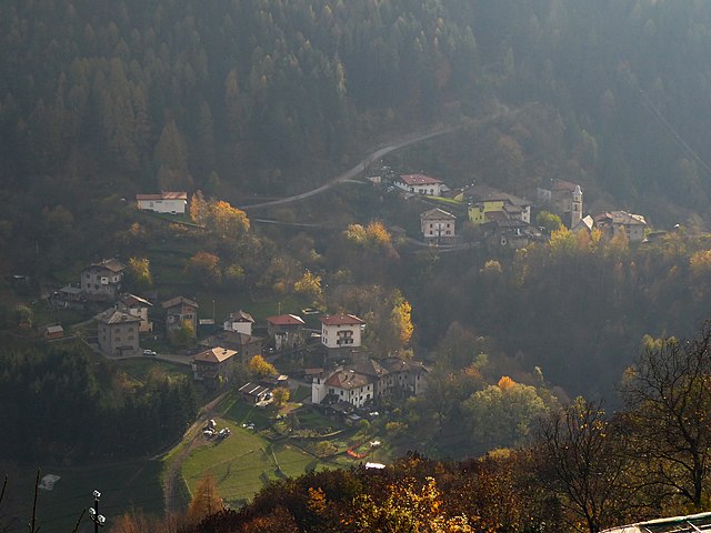
Сегонцано (Segonzano, Segonzano)
%202018.svg)
- коммуна Италии
 Hiking in Сегонцано
Segonzano is a charming village located in the Trentino region of northern Italy, surrounded by stunning natural landscapes, making it an excellent destination for hiking enthusiasts. The area is renowned for its natural beauty, offering a variety of trails ranging from easy walks to more challenging hikes that cater to different skill levels.
Highlights of Hiking in Segonzano:
-
Nature and Scenery: The trails around Segonzano are often surrounded by lush forests, rolling hills, and picturesque views of the Dolomites. The landscape is particularly stunning in spring and autumn when the foliage changes color.
-
The Earth Pyramids: One of the most famous attractions near Segonzano is the Earth Pyramids. These natural formations are a result of erosion and make for a unique hiking experience. There are designated trails that lead you to viewpoints of these fascinating geological structures.
-
Trail Options:
- La Strada dei Pini: A relatively easy trail that offers scenic views and is suitable for families. It's great for a relaxing day hike.
- Sentiero delle Marmotte: This is a more challenging trail that rewards hikers with stunning panoramas and the chance to see local wildlife.
- Hikes along the Avisio River: These routes are relatively flat and are perfect for leisurely walks or a bike ride, providing beautiful views of the river and surrounding meadows.
-
Flora and Fauna: The region is rich in biodiversity. Hikers may encounter a variety of plants, wildflowers, and wildlife, including deer, foxes, and numerous bird species.
-
Seasonal Activities: Hiking in Segonzano is popular year-round. In winter, the area transforms into a winter sports hub, with opportunities for snowshoeing and skiing.
-
Local Culture: Besides the natural attractions, hiking in Segonzano offers opportunities to experience local culture. After a day of hiking, you can enjoy traditional Trentino cuisine in local restaurants or explore the village's charming architecture.
Tips for Hiking in Segonzano:
- Weather Considerations: Always check the weather before heading out, as conditions can change rapidly in the mountains.
- Proper Gear: Wear appropriate hiking boots and carry a backpack with essentials such as water, snacks, a first aid kit, and sunscreen.
- Trail Maps: It’s beneficial to have a map of the trails or a GPS device, as some paths may not be well marked.
- Respect Nature: Follow Leave No Trace principles to help preserve the natural beauty of the area.
Whether you're looking for a peaceful walk or an adventure through the stunning landscapes, hiking in Segonzano offers something for everyone. Enjoy your hike!
- Страна:

- Почтовый код: 38047
- Телефонный код: 0461
- Код автомобильного номера: TN
- Координаты: 46° 11' 0" N, 11° 16' 0" E


- GPS треки (wikiloc): [Ссылка]
- Высота над уровнем моря: 700 м m
- Площадь: 20.71 кв.км
- Население: 1447
- Веб сайт: http://www.comune.segonzano.tn.it
- Википедия русская: wiki(ru)
- Википедия английская: wiki(en)
- Википедия национальная: wiki(it)
- Хранилище Wikidata: Wikidata: Q304120
- Катеория в википедии: [Ссылка]
- код Freebase: [/m/0gb0j9]
- код GeoNames: Альт: [6542685]
- код VIAF: Альт: [237075301]
- ID отношения в OpenStreetMap: [46973]
- код ISTAT: 022172
- кадастровый код Италии: I576
Включает регионы:

Sevignano
Hiking in Sevignano
Sevignano, located in the beautiful region of Tuscany, Italy, offers a picturesque setting for hiking enthusiasts. The area is characterized by its rolling hills, vineyards, olive groves, and charming rural landscapes, making it a delightful location for those looking to explore nature....
- Страна:
- Координаты: 46° 10' 18" N, 11° 14' 52" E
- GPS треки (wikiloc): [Ссылка]
- Высота над уровнем моря: 534 м m

Quaras
Hiking in Quaras
It seems there may be a typo or a misunderstanding regarding the name "Quaras." If you meant "Quaras" as in a specific location, it might be less well-known and I may not have information on that. However, if you are referring to a region like "Quaras" could be an alternate spelling or local name for a well-known hiking area, please clarify so I can provide accurate information....
- Страна:
- Координаты: 46° 10' 28" N, 11° 17' 13" E
- GPS треки (wikiloc): [Ссылка]

Teaio
Hiking in Teaio
It seems there might be a typo in your request for "Teaio." If you meant "Taiwan," let me know! Taiwan has some incredible hiking opportunities, including trails like the famous Taroko Gorge, Alishan, and Yushan....
- Страна:
- Координаты: 46° 11' 38" N, 11° 15' 23" E
- GPS треки (wikiloc): [Ссылка]

Valcava
Hiking in Valcava
Valcava, located in Italy, is a stunning hiking destination that offers breathtaking views, diverse landscapes, and a range of trails suitable for different skill levels. Nestled in the Bergamo Alps, the area is surrounded by lush forests, rolling hills, and picturesque mountain scenery....
- Страна:
- Координаты: 46° 12' 23" N, 11° 18' 43" E
- GPS треки (wikiloc): [Ссылка]

Piazzo
Hiking in Piazzo
Piazzo, located in the municipality of Segonzano in the Trentino region of Italy, offers a beautiful setting for hiking enthusiasts. This area is known for its stunning landscapes, including rolling hills, forests, and picturesque views of the surrounding mountains....
- Страна:
- Почтовый код: 38047
- Телефонный код: 0461
- Координаты: 46° 11' 0" N, 11° 15' 5" E
- GPS треки (wikiloc): [Ссылка]
- Высота над уровнем моря: 534 м m
Saletto
Hiking in Saletto
Saletto isn't a widely known hiking destination, but the surrounding regions of Italy typically offer beautiful landscapes, trails, and outdoor activities. If you’re interested in hiking in areas close to Saletto or in the broader region of Veneto, here are a few things to consider:...
- Страна:
- Координаты: 46° 11' 15" N, 11° 15' 26" E
- GPS треки (wikiloc): [Ссылка]

Parlo
Hiking in Parlo
"Parlo" might refer to a specific location, but it’s not widely recognized as a hiking destination based on the information available until October 2023. Could you provide more details or clarify if you meant a different area, such as a national park, a region, or perhaps a local hiking trail?...
- Страна:
- Координаты: 46° 10' 50" N, 11° 15' 3" E
- GPS треки (wikiloc): [Ссылка]

Prà
Hiking in Prà
Prà is known for its stunning natural landscapes, offering a range of hiking trails suitable for various skill levels. Whether you're looking for an easy walk or a challenging hike, you'll find a path that meets your needs....
- Страна:
- Координаты: 46° 11' 32" N, 11° 15' 4" E
- GPS треки (wikiloc): [Ссылка]
Gresta
Hiking in Gresta
Gresta is a lesser-known but picturesque region located in Italy, ideal for hiking enthusiasts who enjoy scenic views, tranquil nature, and a bit of off-the-beaten-path exploration. Although it may not be as famous as some larger hiking destinations in the country, it offers unique trails and experiences....
- Страна:
- Координаты: 46° 12' 39" N, 11° 17' 29" E
- GPS треки (wikiloc): [Ссылка]

Gaggio
Hiking in Gaggio
Gaggio, a beautiful mountainous area located in the Italian region of Emilia-Romagna, offers a variety of hiking opportunities suitable for different skill levels. The landscape is characterized by stunning views, dense forests, rolling hills, and a network of trails that allow hikers to explore the natural beauty of the region....
- Страна:
- Координаты: 46° 12' 22" N, 11° 17' 20" E
- GPS треки (wikiloc): [Ссылка]

Luch
Hiking in Luch
Luch, located in the Carpathian Mountains of Ukraine, is a fantastic destination for hiking enthusiasts. The region is renowned for its scenic landscapes, diverse wildlife, and rich cultural heritage. Here are some key points about hiking in Luch and the surrounding areas:...
- Страна:
- Координаты: 46° 11' 7" N, 11° 15' 51" E
- GPS треки (wikiloc): [Ссылка]
Sabion
Hiking in Sabion
Sabion, located in the Alpine region of Italy, is a fantastic destination for hiking enthusiasts. This area offers a range of trails that cater to different skill levels, from beginners to experienced hikers. Here are some highlights and tips for hiking in Sabion:...
- Страна:
- Координаты: 46° 11' 23" N, 11° 15' 39" E
- GPS треки (wikiloc): [Ссылка]
Stedro
Hiking in Stedro
It seems like there might be some confusion with the location name "Stedro," as it doesn't correspond to a widely recognized hiking destination. However, if you meant a specific area, park, or trail that might have a similar name, please clarify....
- Страна:
- Координаты: 46° 11' 13" N, 11° 15' 39" E
- GPS треки (wikiloc): [Ссылка]
Casal
Hiking in Casal
Casal, a term often associated with various locations, could refer to different hiking areas depending on the region you're considering. However, if you're referring to a specific area or region named Casal, like Casal de São Simão in Portugal or some other locality with a similar name, I can provide general information about what you might expect from hiking there....
- Страна:
- Координаты: 46° 11' 40" N, 11° 15' 39" E
- GPS треки (wikiloc): [Ссылка]
Граничит с регионами:


Лона-Лазес
- коммуна Италии
Hiking in Лона-Лазес
Lona-Lases is a beautiful area in the Aosta Valley region of Italy, known for its breathtaking views and diverse hiking trails. Here are some key points to consider if you're planning a hiking trip to Lona-Lases:...
- Страна:
- Почтовый код: 38040
- Телефонный код: 0461
- Код автомобильного номера: TN
- Координаты: 46° 9' 0" N, 11° 13' 0" E
- GPS треки (wikiloc): [Ссылка]
- Высота над уровнем моря: 639 м m
- Площадь: 11.37 кв.км
- Население: 881
- Веб сайт: [Ссылка]


Базельга-ди-Пине
- коммуна Италии
Hiking in Базельга-ди-Пине
Baselga di Piné is a beautiful destination for hiking enthusiasts, located in the Trentino region of northern Italy. Nestled in the Italian Alps, it offers stunning landscapes, lush forests, serene lakes, and picturesque mountain views. Here are some key points to consider for hiking in Baselga di Piné:...
- Страна:
- Почтовый код: 38042
- Телефонный код: 0461
- Код автомобильного номера: TN
- Координаты: 46° 7' 47" N, 11° 14' 41" E
- GPS треки (wikiloc): [Ссылка]
- Высота над уровнем моря: 964 м m
- Площадь: 41.07 кв.км
- Население: 5075
- Веб сайт: [Ссылка]
Бедолло
- коммуна Италии
Hiking in Бедолло
Bedollo, located in the Trentino region of northern Italy, is an excellent destination for hiking enthusiasts. The area is known for its stunning landscapes, lush forests, and charming alpine views, which are particularly beautiful during the spring and autumn months....
- Страна:
- Почтовый код: 38043
- Телефонный код: 0461
- Код автомобильного номера: TN
- Координаты: 46° 10' 0" N, 11° 18' 0" E
- GPS треки (wikiloc): [Ссылка]
- Высота над уровнем моря: 1133 м m
- Площадь: 27.46 кв.км
- Население: 1483
- Веб сайт: [Ссылка]


Совер
- коммуна Италии
Hiking in Совер
Sover, located in the state of Vermont, offers a variety of hiking opportunities that cater to different skill levels and preferences. Here are some key details about hiking in and around Sover:...
- Страна:
- Почтовый код: 38048
- Телефонный код: 0461
- Код автомобильного номера: TN
- Координаты: 46° 13' 0" N, 11° 19' 0" E
- GPS треки (wikiloc): [Ссылка]
- Высота над уровнем моря: 854 м m
- Площадь: 14.82 кв.км
- Население: 824
- Веб сайт: [Ссылка]