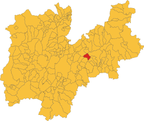
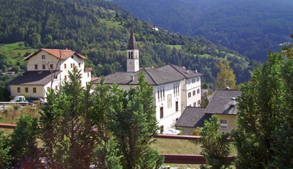
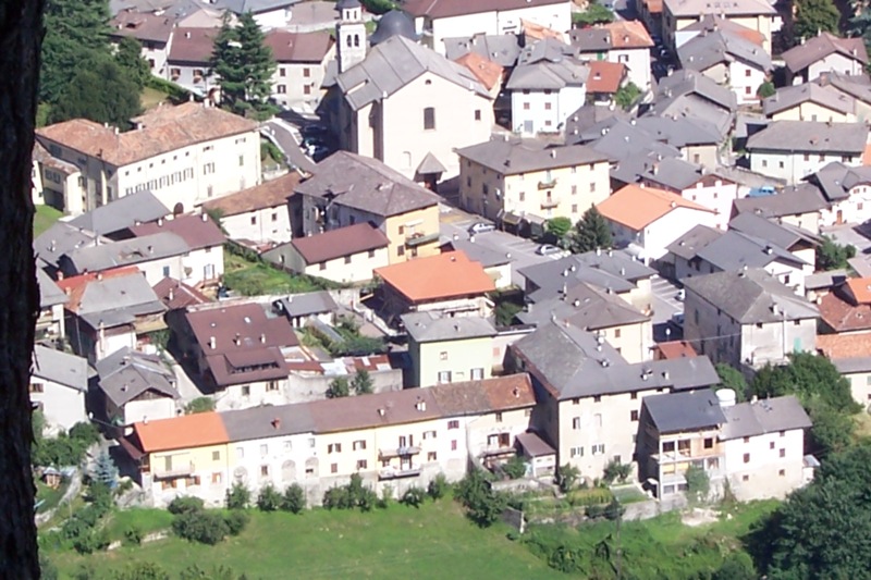
Базельга-ди-Пине (Baselga di Piné, Baselga di Piné)
%202018.svg)
- коммуна Италии
 Hiking in Базельга-ди-Пине
Baselga di Piné is a beautiful destination for hiking enthusiasts, located in the Trentino region of northern Italy. Nestled in the Italian Alps, it offers stunning landscapes, lush forests, serene lakes, and picturesque mountain views. Here are some key points to consider for hiking in Baselga di Piné:
Hiking Trails
-
Variety of Trails: The area has a wide range of trails suitable for all skill levels, from easy strolls around the lakes to more challenging mountain paths.
-
Lakes and Nature: Popular hiking areas include the Lago di Pine and Lago di Serraia, which are great for scenic walks and observing local wildlife.
-
Marked Paths: Trails are well-marked with signs indicating difficulty levels, making it easy for hikers to find routes that suit their abilities.
-
Altopiano di Piné: This plateau features numerous trails that provide breathtaking views of the Dolomites and surrounding landscapes.
Best Season for Hiking
- Spring and Summer: These seasons are ideal for hiking when the weather is mild, and wildflowers are in bloom, perfect for enjoying the natural beauty.
- Autumn: Fall is also a fantastic time for hiking, as the leaves change color and the crowds dissipate, creating a peaceful hiking experience.
Equipment and Preparation
- Gear: Wear sturdy hiking boots, and bring adequate clothing for changing weather, as mountain conditions can vary greatly.
- Navigation: A map or GPS device can be helpful. While trails are marked, having a guide can enhance your experience, especially if you want to explore less-traveled paths.
Additional Activities
- Besides hiking, Baselga di Piné offers activities like mountain biking, swimming in the lakes, and in winter, options for snowshoeing and skiing.
Local Amenities
- Accommodations: There are various lodges, hotels, and campgrounds available in and around Baselga di Piné.
- Dining: Enjoy local cuisine at the numerous restaurants offering delicious regional dishes.
Tips
- Always inform someone about your hiking plans, especially if heading into more remote areas.
- Stay hydrated and carry snacks to keep your energy up on longer hikes.
Whether you are seeking serene nature walks or more adventurous hikes, Baselga di Piné provides an array of options to explore the breathtaking natural beauty of the Trentino region.
- Страна:

- Почтовый код: 38042
- Телефонный код: 0461
- Код автомобильного номера: TN
- Координаты: 46° 7' 47" N, 11° 14' 41" E


- GPS треки (wikiloc): [Ссылка]
- Высота над уровнем моря: 964 м m
- Площадь: 41.07 кв.км
- Население: 5075
- Веб сайт: http://www.comune.baselgadipine.tn.it/
- Википедия русская: wiki(ru)
- Википедия английская: wiki(en)
- Википедия национальная: wiki(it)
- Хранилище Wikidata: Wikidata: Q244005
- Катеория в википедии: [Ссылка]
- код Freebase: [/m/0g9xj5]
- код GeoNames: Альт: [6540652]
- код VIAF: Альт: [234781347]
- ID отношения в OpenStreetMap: [46869]
- место в MusicBrainz: [b1ce81ca-e080-46ec-9260-773e96e5a587]
- код ISTAT: 022009
- кадастровый код Италии: A694
Граничит с регионами:


Лона-Лазес
- коммуна Италии
Hiking in Лона-Лазес
Lona-Lases is a beautiful area in the Aosta Valley region of Italy, known for its breathtaking views and diverse hiking trails. Here are some key points to consider if you're planning a hiking trip to Lona-Lases:...
- Страна:
- Почтовый код: 38040
- Телефонный код: 0461
- Код автомобильного номера: TN
- Координаты: 46° 9' 0" N, 11° 13' 0" E
- GPS треки (wikiloc): [Ссылка]
- Высота над уровнем моря: 639 м m
- Площадь: 11.37 кв.км
- Население: 881
- Веб сайт: [Ссылка]
Бедолло
- коммуна Италии
Hiking in Бедолло
Bedollo, located in the Trentino region of northern Italy, is an excellent destination for hiking enthusiasts. The area is known for its stunning landscapes, lush forests, and charming alpine views, which are particularly beautiful during the spring and autumn months....
- Страна:
- Почтовый код: 38043
- Телефонный код: 0461
- Код автомобильного номера: TN
- Координаты: 46° 10' 0" N, 11° 18' 0" E
- GPS треки (wikiloc): [Ссылка]
- Высота над уровнем моря: 1133 м m
- Площадь: 27.46 кв.км
- Население: 1483
- Веб сайт: [Ссылка]


Форначе
- коммуна Италии
Hiking in Форначе
Fornace is not a specific location widely known in hiking circles. However, it may refer to several places, likely in regions where Italian is spoken, as "fornace" translates to "furnace" in English, often related to places with industrial or historical significance....
- Страна:
- Почтовый код: 38040
- Телефонный код: 0461
- Код автомобильного номера: TN
- Координаты: 46° 7' 5" N, 11° 12' 27" E
- GPS треки (wikiloc): [Ссылка]
- Высота над уровнем моря: 740 м m
- Площадь: 7.22 кв.км
- Население: 1343
- Веб сайт: [Ссылка]

Палу-дель-Ферсина
- коммуна в регионе Трентино — Альто-Адидже, Италия
Hiking in Палу-дель-Ферсина
Palù del Fersina, located in the Trentino region of northern Italy, is a beautiful area known for its stunning natural landscapes, rich biodiversity, and charming mountain villages. Here are some highlights and tips for hiking in this area:...
- Страна:
- Почтовый код: 38050
- Телефонный код: 0461
- Код автомобильного номера: TN
- Координаты: 46° 8' 0" N, 11° 21' 0" E
- GPS треки (wikiloc): [Ссылка]
- Высота над уровнем моря: 1360 м m
- Площадь: 16.65 кв.км
- Население: 168
- Веб сайт: [Ссылка]


Перджине-Вальсугана
- коммуна Италии
Hiking in Перджине-Вальсугана
Pergine Valsugana, located in the Trentino region of northern Italy, is a fantastic destination for hiking enthusiasts. Nestled between the beautiful mountains and the serene lakes, the area offers a variety of trails that cater to all skill levels—from leisurely walks to challenging hikes....
- Страна:
- Почтовый код: 38057
- Телефонный код: 0461
- Код автомобильного номера: TN
- Координаты: 46° 4' 0" N, 11° 14' 0" E
- GPS треки (wikiloc): [Ссылка]
- Высота над уровнем моря: 490 м m
- Площадь: 54.33 кв.км
- Население: 21384
- Веб сайт: [Ссылка]

Сант'Орсола-Терме
- коммуна Италии
Hiking in Сант'Орсола-Терме
Sant'Orsola Terme, located in the Trentino region of northern Italy, is a picturesque destination known for its natural beauty and thermal baths. The area offers a variety of hiking trails suitable for different skill levels, allowing hikers to immerse themselves in the stunning landscapes of the surrounding mountains and forests....
- Страна:
- Почтовый код: 38050
- Телефонный код: 0461
- Код автомобильного номера: TN
- Координаты: 46° 7' 0" N, 11° 18' 0" E
- GPS треки (wikiloc): [Ссылка]
- Высота над уровнем моря: 925 м m
- Площадь: 15.36 кв.км
- Население: 1122
- Веб сайт: [Ссылка]


Сегонцано
- коммуна Италии
Hiking in Сегонцано
Segonzano is a charming village located in the Trentino region of northern Italy, surrounded by stunning natural landscapes, making it an excellent destination for hiking enthusiasts. The area is renowned for its natural beauty, offering a variety of trails ranging from easy walks to more challenging hikes that cater to different skill levels....
- Страна:
- Почтовый код: 38047
- Телефонный код: 0461
- Код автомобильного номера: TN
- Координаты: 46° 11' 0" N, 11° 16' 0" E
- GPS треки (wikiloc): [Ссылка]
- Высота над уровнем моря: 700 м m
- Площадь: 20.71 кв.км
- Население: 1447
- Веб сайт: [Ссылка]

Тельве
- коммуна Италии
Hiking in Тельве
Telve, located in the Trentino region of northern Italy, offers some beautiful hiking opportunities amid the stunning alpine scenery. Nestled near the foothills of the Alps, this area is known for its picturesque landscapes, diverse wildlife, and charming local culture....
- Страна:
- Почтовый код: 38050
- Телефонный код: 0461
- Код автомобильного номера: TN
- Координаты: 46° 4' 0" N, 11° 29' 0" E
- GPS треки (wikiloc): [Ссылка]
- Высота над уровнем моря: 548 м m
- Площадь: 64.75 кв.км
- Население: 2008
- Веб сайт: [Ссылка]


Вальфлориана
- коммуна Италии
Hiking in Вальфлориана
Valfloriana is a picturesque area located in the Trentino region of northern Italy, known for its stunning landscapes, rich biodiversity, and charming villages. Hiking in Valfloriana offers a fantastic experience for outdoor enthusiasts, with a variety of trails suitable for different skill levels....
- Страна:
- Почтовый код: 38040
- Телефонный код: 0462
- Код автомобильного номера: TN
- Координаты: 46° 15' 0" N, 11° 21' 0" E
- GPS треки (wikiloc): [Ссылка]
- Высота над уровнем моря: 853 м m
- Площадь: 39.33 кв.км
- Население: 470
- Веб сайт: [Ссылка]