Senaud (Senaud)

- коммуна во Франции
 Hiking in Senaud
Senaud is a small commune in the Ain department in the Auvergne-Rhône-Alpes region of France. While it may not be as widely known for hiking as some of the larger national parks or mountainous areas in France, there are definitely opportunities for outdoor activities in the surrounding region.
Hiking Opportunities:
-
Nearby Natural Areas: The Ain region features diverse landscapes, including rolling hills, forests, and scenic rivers. You can find various trails that cater to different skill levels. Look for local trails in the nearby Dombes region or Le Haut Bugey, which often have well-marked paths and beautiful nature.
-
Local Parks: Consider visiting regional parks nearby, such as the Parc Naturel Régional du Haut-Jura, which offers numerous hiking routes with varying degrees of difficulty, showcasing the stunning Jura mountain landscape.
-
Scenic Views: Some trails may lead to panoramic views of the surrounding countryside, including vineyards and traditional villages.
Preparing for Your Hike:
- Trail Maps: Make sure to obtain a reliable map or download hiking apps that feature trails in the region. It's essential to know the difficulty level and distance of the trails.
- Gear: Wear appropriate footwear and clothing, and don't forget essentials like water, snacks, a first-aid kit, and sun protection.
- Local Regulations: Always check for any specific regulations or advice for hiking in the area, including weather conditions.
Recommendations:
- Guided Tours: If you’re unfamiliar with the area, consider joining a guided hike to gain insight into the local flora and fauna and enhance your experience.
- Cultural Exploration: Incorporate visits to nearby towns like Bourg-en-Bresse or Oyonnax to experience local culture, cuisine, and history after your hikes.
For more detailed hiking routes and specific local tips, check with regional hiking organizations or visitor centers in the Ain department once you arrive. Happy hiking!
- Страна:

- Почтовый код: 39160
- Координаты: 46° 23' 49" N, 5° 22' 48" E


- GPS треки (wikiloc): [Ссылка]
- Площадь: 4.06 кв.км
- Население: 51
- Википедия английская: wiki(en)
- Википедия национальная: wiki(fr)
- Хранилище Wikidata: Wikidata: Q614634
- Катеория в википедии: [Ссылка]
- код Freebase: [/m/03nvv7_]
- код GeoNames: Альт: [6433758]
- код BNF: [15258870j]
- код муниципалитета INSEE: 39509
Граничит с регионами:


Saint-Jean-d'Étreux
- коммуна во Франции
Hiking in Saint-Jean-d'Étreux
Saint-Jean-d'Étreux is a small commune located in the Jura department of eastern France, known for its beautiful landscapes and outdoor activities, including hiking. The region is characterized by rolling hills, forests, and diverse flora and fauna, making it a great destination for nature enthusiasts....
- Страна:
- Почтовый код: 39160
- Координаты: 46° 24' 17" N, 5° 21' 30" E
- GPS треки (wikiloc): [Ссылка]
- Площадь: 4.28 кв.км
- Население: 156


Val-d'Épy
- коммуна во Франции
Hiking in Val-d'Épy
Val-d'Épy is a charming commune in the Jura department of France, known for its stunning landscapes and outdoor recreational opportunities. Here are a few highlights and tips for hiking in and around Val-d'Épy:...
- Страна:
- Почтовый код: 39160; 39320
- Координаты: 46° 22' 58" N, 5° 23' 55" E
- GPS треки (wikiloc): [Ссылка]
- Высота над уровнем моря: 370 м m
- Площадь: 8.64 кв.км
- Население: 149
Колиньи
- коммуна во Франции
Hiking in Колиньи
Coligny, located in the Ain department in the Auvergne-Rhône-Alpes region of southeastern France, is a charming village that offers a variety of hiking opportunities. The area surrounding Coligny is characterized by beautiful landscapes, rolling hills, and serene natural settings, making it an excellent destination for hikers of all skill levels....
- Страна:
- Почтовый код: 01270
- Координаты: 46° 22' 59" N, 5° 20' 46" E
- GPS треки (wikiloc): [Ссылка]
- Площадь: 16.87 кв.км
- Население: 1193
- Веб сайт: [Ссылка]

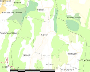
Nantey
- коммуна во Франции
Hiking in Nantey
Nantey is a small commune located in the Auvergne-Rhône-Alpes region of southeastern France. While it may not be as widely known for hiking as some of its more famous counterparts in the French Alps, it offers charming landscapes and opportunities for outdoor activities, including hiking. Here’s what you can expect when hiking in and around Nantey:...
- Страна:
- Почтовый код: 39160
- Координаты: 46° 24' 31" N, 5° 23' 57" E
- GPS треки (wikiloc): [Ссылка]
- Площадь: 6.5 кв.км
- Население: 52