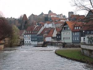
Зоннеберг (Sonneberg, Landkreis Sonneberg)

- район земли Тюрингия, Германия
 Hiking in Зоннеберг
Sonneberg, located in the southern part of Germany, in the state of Thuringia, offers a variety of hiking opportunities that cater to different skill levels and preferences. The district is characterized by its beautiful landscapes, including rolling hills, dense forests, and picturesque valleys.
1.
- Thuringian Forest: This area is part of a larger mountain range and offers numerous well-marked hiking paths. The trails include routes with varying levels of difficulty, suitable for both beginners and experienced hikers.
- Sonneberg and Surrounding Areas: The local trails often wind through forests, alongside rivers, and offer stunning views of the countryside. You might come across small villages where you can take a break or enjoy local cuisine.
2.
- Hiking to the "Hohes Kreuz": This is a popular local high point that provides panoramic views of the surrounding region.
- Lauscha: Known for its glassblowing tradition, Lauscha is a charming village worth visiting while hiking in the area. The trails leading there often offer beautiful scenery and the chance to explore local history.
3.
- Easy Trails: Ideal for families or those looking for a leisurely walk. These trails typically have gentle inclines and well-maintained paths.
- Moderate Trails: Suitable for casual hikers with some experience, featuring varied terrain and occasional steep sections.
- Challenging Trails: For seasoned hikers looking for a workout, these routes may include steep ascents, rocky passages, and longer distances.
4.
- Spring and fall are particularly pleasant times for hiking in Sonneberg when the weather is mild and the landscape is vibrant with colors.
5.
- Always check weather conditions before embarking on a hike.
- Carry sufficient water, snacks, and a map or GPS device.
- Wear appropriate footwear and clothing for the terrain and weather.
6.
- Many trails have access to nearby towns with hotels, guesthouses, and restaurants where hikers can rest and refuel.
7.
- Be on the lookout for local flora and fauna, including various bird species. The forests are often home to deer, foxes, and other wildlife.
In summary, Sonneberg district is a beautiful area for hiking enthusiasts, with its rich natural landscape and well-maintained trails. Whether you're looking for a casual stroll or a challenging trek, there are plenty of options to explore!
- Страна:

- Код автомобильного номера: SON; NH
- Координаты: 50° 24' 36" N, 11° 7' 48" E


- GPS треки (wikiloc): [Ссылка]
- Высота над уровнем моря: 594 м m
- Площадь: 433.61 кв.км
- Население: 56818
- Веб сайт: http://www.landkreis-sonneberg.de/
- Википедия русская: wiki(ru)
- Википедия английская: wiki(en)
- Википедия национальная: wiki(de)
- Хранилище Wikidata: Wikidata: Q7875
- Катеория в википедии: [Ссылка]
- код Freebase: [/m/01_lc9]
- код GeoNames: Альт: [2831245]
- код VIAF: Альт: [137280828]
- ID отношения в OpenStreetMap: [62552]
- код GND: Альт: [4310821-0]
- идентификатор местоположения ArchINFORM: [43151]
- код LCNAF: Альт: [n85307901]
- код темы Quora: [Sonneberg]
- код TGN: [7098660]
- код NUTS: [DEG0H]
- код района Германии: 16072
Граничит с регионами:
Кронах
- район Баварии
Hiking in Кронах
Kronach, located in Bavaria, Germany, is an excellent destination for hiking enthusiasts. The district is characterized by its beautiful landscapes, rich history, and diverse trails suitable for all levels of hikers. Here are some highlights regarding hiking in Kronach:...
- Страна:
- Столица: Кронах
- Код автомобильного номера: SAN; KC
- Координаты: 50° 19' 48" N, 11° 22' 12" E
- GPS треки (wikiloc): [Ссылка]
- Высота над уровнем моря: 412 м m
- Площадь: 651.00 кв.км
- Население: 75353
- Веб сайт: [Ссылка]
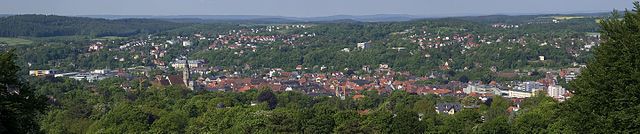
Кобург
- район в Баварии, Германия
Hiking in Кобург
Coburg district, located in Bavaria, Germany, offers a variety of hiking opportunities for outdoor enthusiasts. The region is characterized by beautiful landscapes, including rolling hills, woodlands, and scenic views that make for enjoyable hiking experiences....
- Страна:
- Столица: Кобург
- Код автомобильного номера: NEC; CO
- Координаты: 50° 16' 0" N, 10° 55' 0" E
- GPS треки (wikiloc): [Ссылка]
- Высота над уровнем моря: 306 м m
- Площадь: 592.00 кв.км
- Население: 82033
- Веб сайт: [Ссылка]