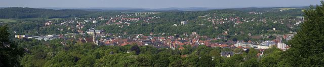
Кронах (Kronach, Landkreis Kronach)


- район Баварии
 Hiking in Кронах
Kronach, located in Bavaria, Germany, is an excellent destination for hiking enthusiasts. The district is characterized by its beautiful landscapes, rich history, and diverse trails suitable for all levels of hikers. Here are some highlights regarding hiking in Kronach:
Scenic Trails
-
Frankenwald Nature Park: This park offers numerous hiking trails through lush forests, rolling hills, and along picturesque rivers. The trails range from easy to moderate, making it accessible for beginners and experienced hikers alike.
-
St. Wolfgang Trail: A popular hiking route that connects several historical sites and offers stunning views of the surrounding landscape. This trail is great for those who enjoy both history and nature.
-
Hiking Along the Rodachtal: This valley features beautiful routes alongside the Rodach River, providing a serene atmosphere and opportunities for wildlife observation.
Historical Sites
Kronach is rich in history, and many hiking trails pass by significant landmarks:
- Kronach Fortress (Veste Kronach): A must-see, this fortress offers panoramic views of the town and surrounding forests.
- Old Town (Altstadt): As you hike, you can explore the historical architecture and local culture within the town of Kronach.
Accessibility
Many trails are well-marked and accessible, with varying lengths and difficulties, which makes them suitable for families, casual walkers, and those looking for a challenge.
Best Time to Hike
Spring and autumn are ideal for hiking in Kronach, as the weather is typically mild, and the landscapes are particularly beautiful during these seasons. Summer can be warm, while winter offers opportunities for winter hikes if you're prepared for snow.
Tips for Hiking
- Stay Hydrated: Always carry enough water, especially on longer hikes.
- Wear Appropriate Footwear: Good hiking boots are essential for comfort and safety.
- Check Weather Conditions: Before heading out, ensure you are aware of the local weather, and plan your hike accordingly.
- Trail Maps: It's a good idea to have a trail map or download a hiking app since some areas might have limited cell service.
Kronach presents an exciting blend of nature and history, making it a great spot for those who love to explore the outdoors while soaking in the local culture.
- Страна:

- Столица: Кронах
- Код автомобильного номера: SAN; KC
- Координаты: 50° 19' 48" N, 11° 22' 12" E


- GPS треки (wikiloc): [Ссылка]
- Высота над уровнем моря: 412 м m
- Площадь: 651.00 кв.км
- Население: 75353
- Веб сайт: http://www.landkreis-kronach.de
- Википедия русская: wiki(ru)
- Википедия английская: wiki(en)
- Википедия национальная: wiki(de)
- Хранилище Wikidata: Wikidata: Q10434
- Катеория в википедии: [Ссылка]
- Карты в википедии: [Ссылка]
- код Freebase: [/m/01xrsh]
- код GeoNames: Альт: [2883782]
- код VIAF: Альт: [244070939]
- ID отношения в OpenStreetMap: [62383]
- код GND: Альт: [4033263-9]
- идентификатор местоположения ArchINFORM: [14506]
- код темы Quora: [Kronach]
- код TGN: [7150304]
- код Historical Gazetteer: [adm_139476]
- Bavarikon ID: [ODB_A00002088]
- код NUTS: [DE24A]
- код BabelNet: [02742709n]
- код района Германии: 09476
Включает регионы:

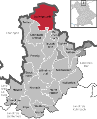
Людвигсштадт
Hiking in Людвигсштадт
Ludwigsstadt, located in Bavaria, Germany, is surrounded by beautiful natural landscapes, making it an excellent destination for hiking enthusiasts. The region is characterized by its rolling hills, forests, and the nearby Thuringian Forest, offering a variety of trails that cater to different skill levels....
- Страна:
- Почтовый код: 96337
- Телефонный код: 09263
- Код автомобильного номера: KC
- Координаты: 50° 29' 9" N, 11° 23' 15" E
- GPS треки (wikiloc): [Ссылка]
- Высота над уровнем моря: 446 м m
- Площадь: 58.72 кв.км
- Население: 3430
- Веб сайт: [Ссылка]
Langenbacher Forst
Hiking in Langenbacher Forst
Langenbacher Forst is a beautiful forest area located in the vicinity of Langenbach, Germany. It offers a variety of hiking opportunities that appeal to both novices and experienced hikers. Here are some details you might find helpful if you're planning a hike there:...
- Страна:
- Координаты: 50° 22' 0" N, 11° 33' 0" E
- GPS треки (wikiloc): [Ссылка]
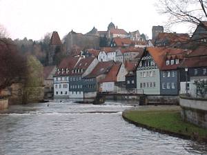
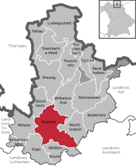
Кронах
- город в Баварии, Германия
Hiking in Кронах
Kronach is a beautiful town located in Bavaria, Germany, known for its rich history and stunning natural landscapes, making it an excellent destination for hiking enthusiasts. Here are some highlights and tips for hiking in and around Kronach:...
- Страна:
- Почтовый код: 96317
- Телефонный код: 09261
- Код автомобильного номера: KC
- Координаты: 50° 14' 28" N, 11° 19' 41" E
- GPS треки (wikiloc): [Ссылка]
- Высота над уровнем моря: 330 м m
- Площадь: 66.99 кв.км
- Население: 18401
- Веб сайт: [Ссылка]


Валленфельс
Hiking in Валленфельс
Wallenfels is a picturesque town located in Bavaria, Germany, surrounded by beautiful landscapes that offer various hiking opportunities. Here are some highlights for hiking in and around Wallenfels:...
- Страна:
- Почтовый код: 96346
- Телефонный код: 09262
- Код автомобильного номера: KC
- Координаты: 50° 16' 3" N, 11° 28' 24" E
- GPS треки (wikiloc): [Ссылка]
- Высота над уровнем моря: 382 м m
- Площадь: 45.60 кв.км
- Население: 2786
- Веб сайт: [Ссылка]


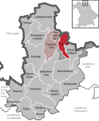
Тойшниц
Hiking in Тойшниц
Teuschnitz is a charming town located in the Franconian Forest region of Bavaria, Germany. The area is known for its picturesque landscapes, dense forests, and diverse hiking trails, making it a great destination for outdoor enthusiasts....
- Страна:
- Почтовый код: 96358
- Телефонный код: 09268
- Код автомобильного номера: KC
- Координаты: 50° 23' 45" N, 11° 22' 50" E
- GPS треки (wikiloc): [Ссылка]
- Высота над уровнем моря: 614 м m
- Площадь: 34.26 кв.км
- Население: 2485
- Веб сайт: [Ссылка]


Шнеккенлоэ
Hiking in Шнеккенлоэ
Schneckenlohe is a picturesque area in Bavaria, Germany, known for its beautiful landscapes and scenic hiking trails. Here are some key points about hiking in Schneckenlohe:...
- Страна:
- Почтовый код: 96277
- Телефонный код: 09266
- Код автомобильного номера: KC
- Координаты: 50° 12' 38" N, 11° 11' 38" E
- GPS треки (wikiloc): [Ссылка]
- Высота над уровнем моря: 326 м m
- Площадь: 9.31 кв.км
- Население: 1168
- Веб сайт: [Ссылка]


Прессиг
Hiking in Прессиг
Pressig is a small village located in the beautiful region of Franconia in Bavaria, Germany. While it may not be as widely recognized as other hiking destinations, Pressig offers access to picturesque landscapes, wooded areas, and serene nature spots that can be enjoyed by hikers of all experience levels....
- Страна:
- Почтовый код: 96332
- Телефонный код: 09265
- Код автомобильного номера: KC
- Координаты: 50° 20' 44" N, 11° 18' 34" E
- GPS треки (wikiloc): [Ссылка]
- Высота над уровнем моря: 375 м m
- Площадь: 53.18 кв.км
- Население: 3981
- Веб сайт: [Ссылка]


Теттау
Hiking in Теттау
Tettau is a picturesque village located in Bavaria, Germany, near the border with Thuringia. It's known for its beautiful natural landscapes, making it a great destination for hiking enthusiasts. Here are some key points about hiking in Tettau:...
- Страна:
- Почтовый код: 96355
- Телефонный код: 09269
- Код автомобильного номера: KC
- Координаты: 50° 28' 12" N, 11° 15' 30" E
- GPS треки (wikiloc): [Ссылка]
- Высота над уровнем моря: 638 м m
- Площадь: 23.80 кв.км
- Население: 2117
- Веб сайт: [Ссылка]


Вильгельмсталь
Hiking in Вильгельмсталь
Wilhelmsthal, located in the state of Bavaria, Germany, is a charming area ideal for hiking enthusiasts. Nestled in a scenic landscape, it offers a range of trails suitable for various skill levels. Here are some highlights to consider if you're planning a hiking trip to Wilhelmsthal:...
- Страна:
- Почтовый код: 96352
- Телефонный код: 09260
- Код автомобильного номера: KC
- Координаты: 50° 18' 40" N, 11° 22' 22" E
- GPS треки (wikiloc): [Ссылка]
- Высота над уровнем моря: 450 м m
- Площадь: 42.91 кв.км
- Население: 3658
- Веб сайт: [Ссылка]

Нордхальбен
Hiking in Нордхальбен
Nordhalben is a charming village located in Bavaria, Germany, surrounded by beautiful natural landscapes that make it an ideal spot for hiking enthusiasts. Nestled in the Franconian Forest, Nordhalben offers a variety of trails suitable for different skill levels, from easy walks to more challenging hikes....
- Страна:
- Почтовый код: 96365
- Телефонный код: 09267
- Код автомобильного номера: KC
- Координаты: 50° 22' 25" N, 11° 30' 40" E
- GPS треки (wikiloc): [Ссылка]
- Высота над уровнем моря: 586 м m
- Площадь: 21.93 кв.км
- Население: 1719
- Веб сайт: [Ссылка]

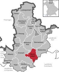
Марктродах
Hiking in Марктродах
Marktrodach is a charming town located in the Franconian region of Bavaria, Germany, known for its beautiful landscapes and outdoor activities. The area is surrounded by forests, hills, and scenic countryside, making it a great destination for hiking enthusiasts....
- Страна:
- Почтовый код: 96364
- Телефонный код: 09261
- Код автомобильного номера: KC
- Координаты: 50° 14' 58" N, 11° 23' 9" E
- GPS треки (wikiloc): [Ссылка]
- Высота над уровнем моря: 340 м m
- Площадь: 33.22 кв.км
- Население: 3729
- Веб сайт: [Ссылка]

Штайнвизен
Hiking in Штайнвизен
Steinwiesen is a picturesque village located in Bavaria, Germany, and is surrounded by beautiful landscapes that are perfect for hiking enthusiasts. Here are some key points about hiking in the Steinwiesen area:...
- Страна:
- Почтовый код: 96349
- Телефонный код: 09267; 09262; 09260
- Код автомобильного номера: KC
- Координаты: 50° 17' 39" N, 11° 27' 43" E
- GPS треки (wikiloc): [Ссылка]
- Высота над уровнем моря: 374 м m
- Площадь: 55.08 кв.км
- Население: 3510
- Веб сайт: [Ссылка]


Штайнбах-ам-Вальд
Hiking in Штайнбах-ам-Вальд
Steinbach am Wald is a charming municipality located in Bavaria, Germany, known for its scenic countryside and natural beauty, making it a great spot for hiking enthusiasts. Here are some highlights and tips for hiking in this area:...
- Страна:
- Почтовый код: 96361
- Телефонный код: 09269; 09268; 09263
- Код автомобильного номера: KC
- Координаты: 50° 25' 57" N, 11° 21' 39" E
- GPS треки (wikiloc): [Ссылка]
- Высота над уровнем моря: 584 м m
- Площадь: 35.47 кв.км
- Население: 3736
- Веб сайт: [Ссылка]


Митвиц
Hiking in Митвиц
Mitwitz is a small yet charming village located in Bavaria, Germany, surrounded by beautiful landscapes that offer various hiking opportunities. The region features rolling hills, forests, and scenic views, making it ideal for outdoor activities such as hiking. Here are some insights into hiking in and around Mitwitz:...
- Страна:
- Почтовый код: 96268
- Телефонный код: 09266
- Код автомобильного номера: KC
- Координаты: 50° 14' 53" N, 11° 12' 35" E
- GPS треки (wikiloc): [Ссылка]
- Высота над уровнем моря: 304 м m
- Площадь: 33.19 кв.км
- Население: 2898
- Веб сайт: [Ссылка]

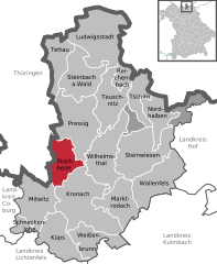
Штокхайм
Hiking in Штокхайм
Stockheim, located in Bavaria, Germany, is surrounded by beautiful landscapes typical of the region, making it a great destination for hiking enthusiasts. The area is known for its rolling hills, lush forests, and scenic views, offering a variety of hiking trails suitable for all levels of experience....
- Страна:
- Почтовый код: 96342
- Телефонный код: 09265
- Код автомобильного номера: KC
- Координаты: 50° 18' 17" N, 11° 17' 1" E
- GPS треки (wikiloc): [Ссылка]
- Высота над уровнем моря: 354 м m
- Площадь: 25.37 кв.км
- Население: 5280
- Веб сайт: [Ссылка]


Кюпс
Hiking in Кюпс
Küps is a small town located in Bavaria, Germany, and it's surrounded by beautiful natural landscapes that are ideal for hiking. While Küps itself may not be a well-known hiking destination, it serves as a great starting point for exploring the scenic trails in the surrounding areas. Here are some tips and highlights for hiking in and around Küps:...
- Страна:
- Почтовый код: 96328
- Телефонный код: 09264; 09261
- Код автомобильного номера: KC
- Координаты: 50° 11' 36" N, 11° 16' 22" E
- GPS треки (wikiloc): [Ссылка]
- Высота над уровнем моря: 299 м m
- Площадь: 35.64 кв.км
- Население: 7700
- Веб сайт: [Ссылка]


Вайсенбрунн
Hiking in Вайсенбрунн
Weißenbrunn is a charming village located in Bavaria, Germany, surrounded by beautiful landscapes that offer excellent hiking opportunities. Here are some highlights and tips for hiking in and around Weißenbrunn:...
- Страна:
- Почтовый код: 96369
- Телефонный код: 09264; 09261; 09223
- Код автомобильного номера: KC
- Координаты: 50° 12' 0" N, 11° 20' 47" E
- GPS треки (wikiloc): [Ссылка]
- Высота над уровнем моря: 330 м m
- Площадь: 26.40 кв.км
- Население: 2919
- Веб сайт: [Ссылка]


Райхенбах
- муниципалитет в германии в Германии, Бавария
Hiking in Райхенбах
Reichenbach, located in Upper Franconia, Bavaria, offers a range of hiking opportunities amidst picturesque landscapes, characterized by rolling hills, lush forests, and quaint villages. Here are some key points to consider if you're planning a hike in this beautiful region:...
- Страна:
- Почтовый код: 96358
- Телефонный код: 09268
- Код автомобильного номера: KC
- Координаты: 50° 25' 30" N, 11° 24' 50" E
- GPS треки (wikiloc): [Ссылка]
- Высота над уровнем моря: 610 м m
- Площадь: 8.65 кв.км
- Население: 966
- Веб сайт: [Ссылка]

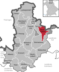
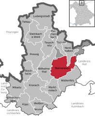
Чирн
Hiking in Чирн
Tschirn is a beautiful village located in Bavaria, Germany, surrounded by scenic landscapes that offer various hiking opportunities. The area is characterized by its picturesque hills, forests, and meadows, making it a great destination for nature lovers and outdoor enthusiasts....
- Страна:
- Почтовый код: 96367
- Телефонный код: 09268
- Код автомобильного номера: KC
- Координаты: 50° 23' 49" N, 11° 26' 59" E
- GPS треки (wikiloc): [Ссылка]
- Высота над уровнем моря: 598 м m
- Площадь: 20.13 кв.км
- Население: 544
- Веб сайт: [Ссылка]
Birnbaum
Hiking in Birnbaum
Gemeindefreies Gebiet Birnbaum, located in Germany, is a unique area that offers a serene and unspoiled nature experience. As it is a community-free zone, you will find tranquility and less crowding compared to more popular hiking destinations. When hiking in Birnbaum, you can expect the following:...
- Страна:
- Координаты: 50° 22' 0" N, 11° 26' 0" E
- GPS треки (wikiloc): [Ссылка]
Граничит с регионами:

Хоф
- район Баварии
Hiking in Хоф
Hof is a district located in Bavaria, Germany, known for its scenic landscapes, charming towns, and outdoor recreational opportunities. The region offers various hiking trails that cater to different skill levels, making it a great destination for both beginners and experienced hikers....
- Страна:
- Столица: Хоф
- Код автомобильного номера: SAN; REH; NAI; MÜB; HO
- Координаты: 50° 15' 0" N, 11° 49' 48" E
- GPS треки (wikiloc): [Ссылка]
- Высота над уровнем моря: 581 м m
- Площадь: 893.00 кв.км
- Население: 105628
- Веб сайт: [Ссылка]

Кульмбах
- район Баварии
Hiking in Кульмбах
Kulmbach district, located in Bavaria, Germany, offers a variety of hiking opportunities that showcase the region’s scenic beauty, rich history, and diverse landscapes. Here are some highlights and tips for hiking in Kulmbach:...
- Страна:
- Столица: Кульмбах
- Код автомобильного номера: SAN; KU; EBS
- Координаты: 50° 5' 12" N, 11° 23' 50" E
- GPS треки (wikiloc): [Ссылка]
- Высота над уровнем моря: 391 м m
- Площадь: 656.00 кв.км
- Население: 73055
- Веб сайт: [Ссылка]
Кобург
- район в Баварии, Германия
Hiking in Кобург
Coburg district, located in Bavaria, Germany, offers a variety of hiking opportunities for outdoor enthusiasts. The region is characterized by beautiful landscapes, including rolling hills, woodlands, and scenic views that make for enjoyable hiking experiences....
- Страна:
- Столица: Кобург
- Код автомобильного номера: NEC; CO
- Координаты: 50° 16' 0" N, 10° 55' 0" E
- GPS треки (wikiloc): [Ссылка]
- Высота над уровнем моря: 306 м m
- Площадь: 592.00 кв.км
- Население: 82033
- Веб сайт: [Ссылка]

Лихтенфельс
- Район в Германии
Hiking in Лихтенфельс
Lichtenfels is a district in Bavaria, Germany, known for its picturesque landscapes and scenic hiking trails. Nestled in the heart of the Franconian region, it offers a variety of hiking opportunities suitable for different skill levels and preferences. Here are some key points about hiking in Lichtenfels:...
- Страна:
- Столица: Лихтенфельс
- Код автомобильного номера: STE; LIF
- Координаты: 50° 6' 36" N, 11° 7' 12" E
- GPS треки (wikiloc): [Ссылка]
- Высота над уровнем моря: 422 м m
- Площадь: 552.00 кв.км
- Население: 65602
- Веб сайт: [Ссылка]
Зоннеберг
- район земли Тюрингия, Германия
Hiking in Зоннеберг
Sonneberg, located in the southern part of Germany, in the state of Thuringia, offers a variety of hiking opportunities that cater to different skill levels and preferences. The district is characterized by its beautiful landscapes, including rolling hills, dense forests, and picturesque valleys....
- Страна:
- Код автомобильного номера: SON; NH
- Координаты: 50° 24' 36" N, 11° 7' 48" E
- GPS треки (wikiloc): [Ссылка]
- Высота над уровнем моря: 594 м m
- Площадь: 433.61 кв.км
- Население: 56818
- Веб сайт: [Ссылка]
Зальфельд-Рудольштадт
- район земли Тюрингия, Германия
Hiking in Зальфельд-Рудольштадт
Saalfeld-Rudolstadt, located in Thuringia, Germany, is known for its diverse and picturesque landscapes, making it an excellent destination for hiking enthusiasts. The region features a mix of forests, hills, and rivers, providing a variety of trails suitable for all skill levels....
- Страна:
- Код автомобильного номера: SLF; RU
- Координаты: 50° 40' 12" N, 11° 19' 48" E
- GPS треки (wikiloc): [Ссылка]
- Высота над уровнем моря: 668 м m
- Площадь: 1036.03 кв.км
- Население: 109278
- Веб сайт: [Ссылка]


Заале-Орла
- район земли Тюрингия, Германия
Hiking in Заале-Орла
Hiking in Saale-Orla-Kreis, located in the Free State of Thuringia, Germany, offers a wonderful experience for outdoor enthusiasts. The region is characterized by its diverse landscapes, which include rolling hills, dense forests, vibrant meadows, and charming villages. Here’s a brief overview of what hikers can expect in this area:...
- Страна:
- Столица: Шлайц
- Код автомобильного номера: SOK
- Координаты: 50° 34' 48" N, 11° 45' 0" E
- GPS треки (wikiloc): [Ссылка]
- Высота над уровнем моря: 472 м m
- Площадь: 1151.3 кв.км
- Население: 82951
- Веб сайт: [Ссылка]