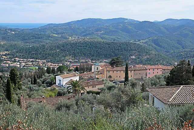
Сперасед (Spéracèdes, Spéracèdes)

- коммуна в департаменте Приморские Альпы, регион Прованс — Альпы — Лазурный Берег, Франция
 Hiking in Сперасед
Spéracèdes is a charming village located in the Alpes-Maritimes department in the Provence-Alpes-Côte d'Azur region of France. It offers a variety of hiking opportunities amidst stunning landscapes, rolling hills, and nearby natural parks. Here are some highlights and tips for hiking in and around Spéracèdes:
Hiking Trails
-
Sentier des Douaniers: This trail offers beautiful views of the surrounding countryside and the Mediterranean coastline. It’s well-marked and suitable for various fitness levels.
-
Col de la Crous: A more challenging hike that rewards you with breathtaking panoramic views. The trail can be steep in places, so it’s best for experienced hikers.
-
Exploring Nearby Natural Parks: Spéracèdes is close to natural parks like the Mercantour National Park, where you can find numerous trails featuring diverse flora and fauna.
What to Expect
- Scenic Views: Most trails in the area provide stunning vistas of the French Riviera, the Lérins Islands, and the foothills of the Alps.
- Cultural Landmarks: You may encounter charming stone houses, olive groves, and local wildlife along your hike.
- Peaceful Environment: Spéracèdes tends to be less crowded than some coastal areas, offering a more tranquil hiking experience.
Hiking Tips
- Season: Spring and autumn offer the perfect weather for hiking, with mild temperatures and fewer tourists. Summer can be hot, so starting early in the day is advisable.
- Gear: Wear sturdy hiking boots and bring plenty of water, a map (or GPS), sunscreen, and a hat.
- Local Regulations: Follow local signage and regulations, especially when hiking in protected areas.
- The Village: After your hike, take some time to explore Spéracèdes itself. The village has a lovely atmosphere, historic architecture, and local shops for refreshments or souvenirs.
Safety Reminders
- Always check the weather forecast before heading out, and be prepared for changing conditions.
- Inform someone about your hiking plans and estimated return time, especially if you’re hiking alone.
- Respect nature and wildlife; take your trash with you and stay on marked paths to preserve the environment.
Enjoy your hiking adventures in Spéracèdes and the beautiful regions surrounding it!
- Страна:

- Почтовый код: 06530
- Координаты: 43° 38' 55" N, 6° 51' 31" E


- GPS треки (wikiloc): [Ссылка]
- Площадь: 3.46 кв.км
- Население: 1295
- Википедия русская: wiki(ru)
- Википедия английская: wiki(en)
- Википедия национальная: wiki(fr)
- Хранилище Wikidata: Wikidata: Q585268
- Катеория в википедии: [Ссылка]
- код Freebase: [/m/03m4_23]
- код Freebase: [/m/03m4_23]
- номер SIREN: [210601373]
- номер SIREN: [210601373]
- код муниципалитета INSEE: 06137
- код муниципалитета INSEE: 06137
Граничит с регионами:

Пейменад
- коммуна в департаменте Приморские Альпы, регион Прованс — Альпы — Лазурный Берег, Франция
Hiking in Пейменад
Peymeinade, a charming village located in the Alpes-Maritimes region of France, is an excellent starting point for hiking enthusiasts. Nestled in the foothills of the picturesque Provencal countryside, it offers a variety of trails that cater to all skill levels....
- Страна:
- Почтовый код: 06530
- Координаты: 43° 38' 32" N, 6° 52' 33" E
- GPS треки (wikiloc): [Ссылка]
- Площадь: 9.76 кв.км
- Население: 8116
- Веб сайт: [Ссылка]

Кабри
- коммуна в департаменте Приморские Альпы, регион Прованс — Альпы — Лазурный Берег, Франция
Hiking in Кабри
Cabris is a charming village located in the Alpes-Maritimes department of the Provence-Alpes-Côte d'Azur region in southeastern France. Perched on a hill, it offers stunning views of the surrounding countryside, making it a wonderful base for hiking enthusiasts. Here are some highlights of hiking in the Cabris area:...
- Страна:
- Почтовый код: 06530
- Координаты: 43° 39' 22" N, 6° 52' 25" E
- GPS треки (wikiloc): [Ссылка]
- Площадь: 5.43 кв.км
- Население: 1295
- Веб сайт: [Ссылка]


Сен-Валье-де-Тье
- коммуна в департаменте Приморские Альпы, регион Прованс — Альпы — Лазурный Берег, Франция
Hiking in Сен-Валье-де-Тье
Saint-Vallier-de-Thiey is a charming village located in the Alpes-Maritimes department in southeastern France, offering a variety of hiking opportunities amidst beautiful landscapes. The region is characterized by its diverse terrain, which includes forested areas, rocky outcrops, and panoramic views of the surrounding mountains and valleys....
- Страна:
- Почтовый код: 06460
- Координаты: 43° 41' 56" N, 6° 50' 52" E
- GPS треки (wikiloc): [Ссылка]
- Площадь: 50.68 кв.км
- Население: 3526

Сен-Сезер-сюр-Сьянь
- коммуна в департаменте Приморские Альпы, регион Прованс — Альпы — Лазурный Берег, Франция
Hiking in Сен-Сезер-сюр-Сьянь
Saint-Cézaire-sur-Siagne is a picturesque village located in the Alpes-Maritimes department of France, near the Mediterranean coast. This area is renowned for its beautiful landscapes, lush vegetation, and proximity to the Siagne River, making it a wonderful spot for hiking enthusiasts....
- Страна:
- Почтовый код: 06530
- Координаты: 43° 38' 56" N, 6° 47' 34" E
- GPS треки (wikiloc): [Ссылка]
- Площадь: 30.02 кв.км
- Население: 3927
- Веб сайт: [Ссылка]

Ле-Тинье
- коммуна в департаменте Приморские Альпы, регион Прованс — Альпы — Лазурный Берег, Франция
Hiking in Ле-Тинье
Le Tignet is a charming village located in the Alpes-Maritimes region of France, not far from the French Riviera. It's known for its beautiful landscapes, picturesque views, and proximity to the Verdon Gorge and the hills of the Provence hinterlands. Here are some key aspects of hiking in this area:...
- Страна:
- Почтовый код: 06530
- Координаты: 43° 37' 45" N, 6° 50' 37" E
- GPS треки (wikiloc): [Ссылка]
- Площадь: 11.26 кв.км
- Население: 3311