Ле-Тинье (Le Tignet, Le Tignet)

- коммуна в департаменте Приморские Альпы, регион Прованс — Альпы — Лазурный Берег, Франция
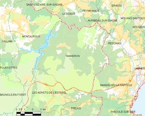
 Hiking in Ле-Тинье
Le Tignet is a charming village located in the Alpes-Maritimes region of France, not far from the French Riviera. It's known for its beautiful landscapes, picturesque views, and proximity to the Verdon Gorge and the hills of the Provence hinterlands. Here are some key aspects of hiking in this area:
Trails and Scenery
- Variety of Trails: The region offers a variety of hiking trails suitable for different skill levels, from easy walks to challenging hikes. Many trails are well-marked and meander through lush forests, vineyards, and fields of wildflowers.
- Stunning Views: Hikers can enjoy breathtaking views of the surrounding mountains, valleys, and sometimes even the Mediterranean Sea on clear days. The contrast of green hills and blue skies makes for a rewarding experience.
Popular Hiking Routes
- Plateau de Caussols: A little further from Le Tignet, this area offers beautiful panorama hikes with unique rock formations and diverse flora.
- Gorges du Loup: A bit accessible from Le Tignet, this gorge provides several trails along the river that lead to breathtaking waterfalls and scenic viewpoints.
- Follow GR Trails: The Grande Randonnée (GR) trails often pass through the region, providing longer multi-day hiking options for those looking to explore more of the Provence landscapes.
Tips for Hiking in Le Tignet
- Seasonal Considerations: Spring and early fall are ideal times for hiking in the region, with mild temperatures and blooming nature. Summer can be hot, so plan hikes for early morning or late afternoon.
- Local Wildlife: Keep an eye out for local wildlife, including various birds and possibly deer. Be respectful of their habitats.
- Hydration and Snacks: Bring plenty of water and snacks, especially on longer hikes, as facilities may not be readily available once you're on the trails.
- Safety: Always inform someone about your hiking plans, especially if you're going on secluded trails. It's also advised to carry a map or GPS device as some areas may have limited cell phone coverage.
Additional Activities
Beyond hiking, Le Tignet offers opportunities for cycling, horseback riding, and exploring the local culture and cuisine. Consider taking time to visit local markets or enjoy the regional specialties in this picturesque part of France.
Whether you're an experienced hiker or a beginner, Le Tignet provides a peaceful escape into nature with plenty of opportunities to explore the stunning landscapes of Provence.
- Страна:

- Почтовый код: 06530
- Координаты: 43° 37' 45" N, 6° 50' 37" E


- GPS треки (wikiloc): [Ссылка]
- Площадь: 11.26 кв.км
- Население: 3311
- Википедия русская: wiki(ru)
- Википедия английская: wiki(en)
- Википедия национальная: wiki(fr)
- Хранилище Wikidata: Wikidata: Q868100
- Катеория в википедии: [Ссылка]
- код Freebase: [/m/03m4zq2]
- код Freebase: [/m/03m4zq2]
- код GeoNames: Альт: [6455474]
- код GeoNames: Альт: [6455474]
- номер SIREN: [210601407]
- номер SIREN: [210601407]
- код муниципалитета INSEE: 06140
- код муниципалитета INSEE: 06140
Граничит с регионами:


Сперасед
- коммуна в департаменте Приморские Альпы, регион Прованс — Альпы — Лазурный Берег, Франция
Hiking in Сперасед
Spéracèdes is a charming village located in the Alpes-Maritimes department in the Provence-Alpes-Côte d'Azur region of France. It offers a variety of hiking opportunities amidst stunning landscapes, rolling hills, and nearby natural parks. Here are some highlights and tips for hiking in and around Spéracèdes:...
- Страна:
- Почтовый код: 06530
- Координаты: 43° 38' 55" N, 6° 51' 31" E
- GPS треки (wikiloc): [Ссылка]
- Площадь: 3.46 кв.км
- Население: 1295

Пейменад
- коммуна в департаменте Приморские Альпы, регион Прованс — Альпы — Лазурный Берег, Франция
Hiking in Пейменад
Peymeinade, a charming village located in the Alpes-Maritimes region of France, is an excellent starting point for hiking enthusiasts. Nestled in the foothills of the picturesque Provencal countryside, it offers a variety of trails that cater to all skill levels....
- Страна:
- Почтовый код: 06530
- Координаты: 43° 38' 32" N, 6° 52' 33" E
- GPS треки (wikiloc): [Ссылка]
- Площадь: 9.76 кв.км
- Население: 8116
- Веб сайт: [Ссылка]

Таннерон
- коммуна во Франции
Hiking in Таннерон
Tanneron is a picturesque village located in the Alpes-Maritimes department in the Provence-Alpes-Côte d'Azur region of southeastern France. Known for its stunning natural landscapes, the area offers a variety of hiking opportunities that cater to different experience levels....
- Страна:
- Почтовый код: 83440
- Координаты: 43° 35' 26" N, 6° 52' 32" E
- GPS треки (wikiloc): [Ссылка]
- Площадь: 52.78 кв.км
- Население: 1572


Монтору
- коммуна во Франции
Hiking in Монтору
Montauroux, located in the Var department of the Provence-Alpes-Côte d'Azur region in southeastern France, offers a stunning backdrop for hikers with its picturesque landscapes, charming villages, and proximity to the beautiful French Riviera. Here are some highlights about hiking in Montauroux:...
- Страна:
- Почтовый код: 83440
- Координаты: 43° 37' 6" N, 6° 45' 55" E
- GPS треки (wikiloc): [Ссылка]
- Площадь: 33.54 кв.км
- Население: 6298

Сен-Сезер-сюр-Сьянь
- коммуна в департаменте Приморские Альпы, регион Прованс — Альпы — Лазурный Берег, Франция
Hiking in Сен-Сезер-сюр-Сьянь
Saint-Cézaire-sur-Siagne is a picturesque village located in the Alpes-Maritimes department of France, near the Mediterranean coast. This area is renowned for its beautiful landscapes, lush vegetation, and proximity to the Siagne River, making it a wonderful spot for hiking enthusiasts....
- Страна:
- Почтовый код: 06530
- Координаты: 43° 38' 56" N, 6° 47' 34" E
- GPS треки (wikiloc): [Ссылка]
- Площадь: 30.02 кв.км
- Население: 3927
- Веб сайт: [Ссылка]