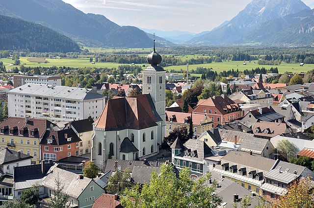
Шпиталь-ам-Пихрн (Spital am Pyhrn, Spital am Pyhrn)
 Hiking in Шпиталь-ам-Пихрн
Spital am Pyhrn, located in the scenic Pyhrn-Priel region of Austria, is a fantastic destination for hiking enthusiasts. Nestled in the foothills of the Alps and surrounded by lush forests, alpine meadows, and striking mountain landscapes, it offers a variety of hiking trails suitable for all levels.
Popular Hiking Trails:
-
Sonnalm Trail (Sonnalm-Wanderung): This moderate hike takes you through beautiful alpine meadows and offers stunning views of the surrounding mountains. The trail is well-marked and is great for families.
-
Großer Pyhrgas: For more experienced hikers, the ascent to the summit of Großer Pyhrgas is a rewarding challenge. The hike provides breathtaking panoramas and a sense of accomplishment upon reaching the peak.
-
Wurzeralm: This area is known for its beautiful, varied trails. You can take the cable car to Wurzeralm and explore numerous paths that vary in difficulty, enabling you to enjoy both short walks and longer hikes.
-
Friedenskirche Trail: It is a relatively easy hike that leads to the Friedenskirche (Peace Church), a small chapel with stunning views of the region. This is a great option for a family outing.
Tips for Hiking in Spital am Pyhrn:
- Weather: Always check the weather forecast before setting out, as conditions can change rapidly in the mountains.
- Footwear: Wear appropriate hiking boots for comfort and support, especially on rugged trails.
- Trail Marking: Trails are usually well-marked, but it’s advisable to carry a map or a GPS device for navigation.
- Hydration and Snacks: Bring enough water and snacks, especially for longer hikes, as facilities might be limited on the trails.
- Local Advice: Don’t hesitate to speak with local guides or tourism offices for advice on trail conditions and recommendations.
Additional Activities:
Apart from hiking, the region offers opportunities for mountain biking, climbing, and during winter, skiing and snowboarding at nearby resorts, making Spital am Pyhrn a year-round outdoor destination.
Whether you are seeking a leisurely hike through picturesque landscapes or a challenging ascent to a mountain peak, Spital am Pyhrn has something to offer for everyone. Enjoy your hiking adventure!
- Страна:

- Почтовый код: 4582
- Телефонный код: 07563
- Код автомобильного номера: KI
- Координаты: 47° 39' 55" N, 14° 20' 27" E


- GPS треки (wikiloc): [Ссылка]
- Высота над уровнем моря: 640 м m
- Площадь: 108.9 кв.км
- Население: 2234
- Веб сайт: http://www.spital-pyhrn.at/
- Википедия русская: wiki(ru)
- Википедия английская: wiki(en)
- Википедия национальная: wiki(de)
- Хранилище Wikidata: Wikidata: Q681330
- Катеория в википедии: [Ссылка]
- код Freebase: [/m/03gv601]
- код GeoNames: Альт: [7872047]
- код BNF: [15296392t]
- код VIAF: Альт: [141990284]
- код GND: Альт: [4056307-8]
- идентификатор местоположения ArchINFORM: [42344]
- код LCNAF: Альт: [n87848090]
- WOEID: [12674433]
- код австрийского муниципалитета: [40918]
Граничит с регионами:

Адмонт
Hiking in Адмонт
Admont, located in the Austrian state of Styria, is known for its stunning natural landscapes and is a fantastic destination for hiking enthusiasts. Nestled at the edge of the Gesäuse National Park, the region is characterized by its dramatic mountains, lush valleys, and crystal-clear rivers....
- Страна:
- Телефонный код: 03613
- Код автомобильного номера: LI
- Координаты: 47° 34' 23" N, 14° 27' 40" E
- GPS треки (wikiloc): [Ссылка]
- Высота над уровнем моря: 640 м m
- Площадь: 299.69 кв.км
- Население: 5010
- Веб сайт: [Ссылка]


Розенау-ам-Хенгстпас
Hiking in Розенау-ам-Хенгстпас
Rosenau am Hengstpass is a beautiful area in Austria, offering a range of hiking opportunities amidst stunning natural scenery. Nestled in the foothills of the Alps, the region is characterized by lush forests, alpine meadows, and panoramic views. Here are some key points to consider for hiking in this area:...
- Страна:
- Почтовый код: 4581
- Телефонный код: 07566
- Код автомобильного номера: KI
- Координаты: 47° 42' 49" N, 14° 23' 46" E
- GPS треки (wikiloc): [Ссылка]
- Высота над уровнем моря: 700 м m
- Площадь: 108.3 кв.км
- Население: 663
- Веб сайт: [Ссылка]

Арднинг
Hiking in Арднинг
Ardning is a picturesque village located in the Steiermark (Styria) region of Austria, known for its stunning natural landscapes and variety of hiking trails. Here are some highlights and tips for hiking in Ardning:...
- Страна:
- Почтовый код: 8904
- Телефонный код: 03612
- Код автомобильного номера: LI
- Координаты: 47° 35' 29" N, 14° 21' 50" E
- GPS треки (wikiloc): [Ссылка]
- Высота над уровнем моря: 696 м m
- Площадь: 34.03 кв.км
- Население: 1239
- Веб сайт: [Ссылка]
Эдльбах
Hiking in Эдльбах
Edlbach is a beautiful area located in Upper Austria, nestled in the foothills of the Alps. It's an excellent destination for hiking enthusiasts, offering a variety of trails suitable for different skill levels. Here are some highlights of hiking in Edlbach:...
- Страна:
- Почтовый код: 4580
- Телефонный код: 07562
- Код автомобильного номера: KI
- Координаты: 47° 42' 45" N, 14° 22' 0" E
- GPS треки (wikiloc): [Ссылка]
- Высота над уровнем моря: 770 м m
- Площадь: 8.3 кв.км
- Население: 670
- Веб сайт: [Ссылка]

Виндишгарстен
Hiking in Виндишгарстен
Windischgarsten, located in the beautiful Salzkammergut region of Austria, is a fantastic destination for hiking enthusiasts. Set against the stunning backdrop of the Alps, this area offers a range of hiking trails that cater to different skill levels, from leisurely strolls to challenging mountain hikes....
- Страна:
- Почтовый код: 4580
- Телефонный код: 07562
- Код автомобильного номера: KI
- Координаты: 47° 43' 16" N, 14° 19' 51" E
- GPS треки (wikiloc): [Ссылка]
- Высота над уровнем моря: 602 м m
- Площадь: 4.9 кв.км
- Население: 2400
- Веб сайт: [Ссылка]
Фордерстодер
Hiking in Фордерстодер
Vorderstoder is a beautiful village located in the Upper Austria region, nestled in the stunning Ennstal Alps. It’s a fantastic destination for hiking enthusiasts, offering a range of trails suitable for various skill levels, from easy walks to challenging mountain hikes. Here are some key highlights and tips for hiking in Vorderstoder:...
- Страна:
- Почтовый код: 4574
- Телефонный код: 07564
- Код автомобильного номера: KI
- Координаты: 47° 42' 45" N, 14° 13' 31" E
- GPS треки (wikiloc): [Ссылка]
- Высота над уровнем моря: 810 м m
- Площадь: 37.1 кв.км
- Население: 810
- Веб сайт: [Ссылка]

Рослайтен
Hiking in Рослайтен
Roßleithen, located in the beautiful Salzkammergut region of Austria, offers a variety of hiking options for outdoor enthusiasts of all levels. The area is characterized by stunning landscapes, rolling hills, and panoramic views of the surrounding mountains, making it a great destination for both leisurely walks and more challenging hikes....
- Страна:
- Почтовый код: 4575
- Телефонный код: 07562
- Код автомобильного номера: KI
- Координаты: 47° 43' 29" N, 14° 18' 36" E
- GPS треки (wikiloc): [Ссылка]
- Высота над уровнем моря: 588 м m
- Площадь: 67.5 кв.км
- Население: 1889
- Веб сайт: [Ссылка]
Лицен
Hiking in Лицен
Liezen, located in the Austrian state of Styria, offers a range of stunning hiking trails that cater to different skill levels. The scenic landscapes, including mountains, forests, and lakes, make it a perfect destination for outdoor enthusiasts....
- Страна:
- Почтовый код: 8940
- Телефонный код: 03612
- Код автомобильного номера: LI
- Координаты: 47° 34' 0" N, 14° 14' 0" E
- GPS треки (wikiloc): [Ссылка]
- Высота над уровнем моря: 664 м m
- Площадь: 91.72 кв.км
- Население: 8086
- Веб сайт: [Ссылка]