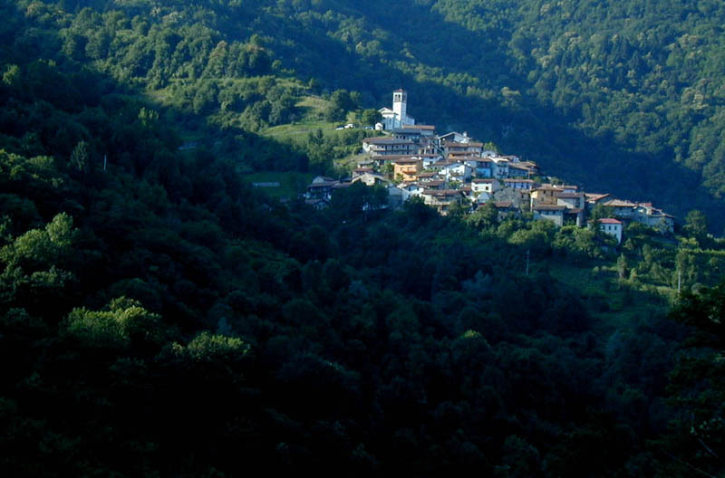
Стренья (Stregna, Stregna)
.svg)
- коммуна Италии
 Hiking in Стренья
Stregna is a picturesque area located in the Friuli Venezia Giulia region of northeastern Italy, close to the border with Slovenia. This region is characterized by its stunning natural landscapes, including rolling hills, dense forests, and beautiful views of the surrounding mountains. Here's what you can expect when hiking in Stregna:
Trails and Routes
Stregna offers a variety of hiking trails suitable for different skill levels, from leisurely walks to more challenging hikes. Many trails are well-marked, and you can find routes that lead you through its beautiful landscapes, vineyards, and quaint villages.
Highlights
- Scenic Views: Many trails provide breathtaking views of the Julian Alps and the picturesque valleys below.
- Natural Beauty: The area is rich in flora and fauna, making it a great spot for nature lovers and photographers.
- Cultural and Historical Sites: Along the hiking routes, you may come across historical sites, such as old churches and fortifications, which add cultural depth to your experience.
Tips for Hiking in Stregna
- Prepare: Check the weather forecast, wear appropriate clothing, and bring enough water and snacks.
- Maps and Guides: Although trails are marked, carrying a physical map or downloading a hiking app can enhance your experience.
- Respect Nature: Stick to marked trails to preserve the local ecosystem and carry out all trash.
- Safety: If hiking alone, inform someone of your plans, and consider joining a guided tour if you're unfamiliar with the area.
Best Time to Visit
The ideal time for hiking in Stregna is during spring (April to June) and fall (September to October) when the weather is generally mild, and the scenery is particularly beautiful, with wildflowers blooming or foliage changing.
Local Amenities
While Stregna is a small village, you can find local accommodations, restaurants, and shops. It's a fantastic idea to try local cuisine, which often includes traditional Friulian dishes.
Hiking in Stregna offers a wonderful combination of nature and culture, making it a rewarding experience for outdoor enthusiasts. Enjoy your adventure!
- Страна:

- Почтовый код: 33040
- Телефонный код: 0432
- Код автомобильного номера: UD
- Координаты: 46° 7' 37" N, 13° 34' 38" E


- GPS треки (wikiloc): [Ссылка]
- Высота над уровнем моря: 404 м m
- Площадь: 19.69 кв.км
- Население: 348
- Веб сайт: http://www.comune.stregna.ud.it/
- Википедия русская: wiki(ru)
- Википедия английская: wiki(en)
- Википедия национальная: wiki(it)
- Хранилище Wikidata: Wikidata: Q53367
- Катеория в википедии: [Ссылка]
- код Freebase: [/m/0gkbd7]
- код GeoNames: Альт: [6536692]
- ID отношения в OpenStreetMap: [79082]
- код ISTAT: 030111
- кадастровый код Италии: I974
Граничит с регионами:

Гримакко
- коммуна Италии
Hiking in Гримакко
Grimacco is a small village located in the region of Friuli Venezia Giulia in northeastern Italy. It's nestled in the scenic hills near the Julian Alps, making it a lovely spot for hiking enthusiasts. Here are some highlights about hiking in and around Grimacco:...
- Страна:
- Почтовый код: 33040
- Телефонный код: 0432
- Код автомобильного номера: UD
- Координаты: 46° 9' 20" N, 13° 34' 11" E
- GPS треки (wikiloc): [Ссылка]
- Высота над уровнем моря: 248 м m
- Площадь: 16.11 кв.км
- Население: 334
- Веб сайт: [Ссылка]


Препотто
- коммуна Италии
Hiking in Препотто
Prepotto, located in the northeastern part of Italy, in the region of Friuli Venezia Giulia, is a beautiful destination for hiking enthusiasts. The area is known for its stunning landscapes, rolling hills, vineyards, and a rich cultural heritage....
- Страна:
- Почтовый код: 33040
- Телефонный код: 0432
- Код автомобильного номера: UD
- Координаты: 46° 2' 43" N, 13° 28' 45" E
- GPS треки (wikiloc): [Ссылка]
- Высота над уровнем моря: 105 м m
- Площадь: 33.24 кв.км
- Население: 753
- Веб сайт: [Ссылка]


Сан-Леонардо
- коммуна в Италии
Hiking in Сан-Леонардо
San Leonardo is a charming village located in the Friuli-Venezia Giulia region of northeastern Italy. The area is known for its stunning natural landscapes, characterized by rolling hills, lush forests, and picturesque vineyards. Hiking in this region offers a variety of trails that cater to different skill levels and preferences, making it an excellent destination for outdoor enthusiasts....
- Страна:
- Почтовый код: 33040
- Телефонный код: 0432
- Код автомобильного номера: UD
- Координаты: 46° 7' 7" N, 13° 31' 53" E
- GPS треки (wikiloc): [Ссылка]
- Высота над уровнем моря: 168 м m
- Площадь: 26.91 кв.км
- Население: 1110
- Веб сайт: [Ссылка]