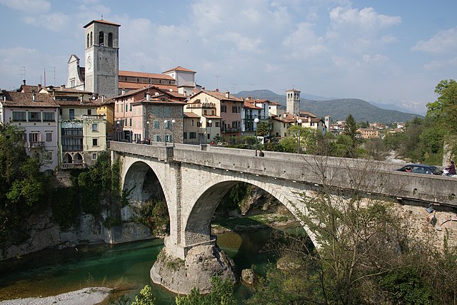
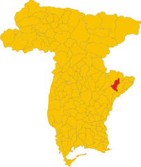
Препотто (Prepotto, Prepotto)
.svg)
- коммуна Италии
 Hiking in Препотто
Prepotto, located in the northeastern part of Italy, in the region of Friuli Venezia Giulia, is a beautiful destination for hiking enthusiasts. The area is known for its stunning landscapes, rolling hills, vineyards, and a rich cultural heritage.
Hiking Trails
Prepotto offers a variety of trails suitable for different skill levels, from easy walks to more challenging hikes. Some popular routes include:
-
Monte Nudo: This trail takes you to the summit of Monte Nudo, where you'll be rewarded with panoramic views of the surrounding hills and valleys. The hike is moderate in difficulty and usually takes about 2-4 hours round trip.
-
Vineyard Trails: Many trails wind through the vineyards that characterize this part of Friuli. These paths are often less challenging and allow you to explore the local wine culture. Some routes may even include wine tasting stops!
-
The Glinščica Valley: This area offers a beautiful landscape with a gentle ascent, ideal for families and beginners. You can enjoy the natural beauty while observing various plant and animal species.
-
Cave of Villanova: For those interested in geology and history, this hike leads to small caves and interesting rock formations, along with prehistoric findings.
Planning Your Hike
-
Best Time to Visit: The best seasons for hiking in Prepotto are spring (April to June) and fall (September to October) when the weather is mild and the landscapes are particularly beautiful.
-
What to Bring: Always carry enough water, snacks, a map or GPS device, and wear appropriate hiking shoes. Sunscreen and a hat can be essential during summer hikes.
-
Local Tips: It's a good idea to check with local tourism offices for updated trail conditions and recommendations. They can provide information on guided tours and local guides who can enhance your experience.
Additional Attractions
Besides hiking, Prepotto is known for its local wines, particularly the Friulano and other white varieties. Consider visiting a winery for a tasting session after your hike. Additionally, the nearby towns and villages offer historical sites and local cuisine worth exploring.
Overall, Prepotto offers a unique combination of outdoor adventure and cultural experiences, making it a great destination for hikers of all levels. Enjoy the beautiful scenery and the charm of this Italian region!
- Страна:

- Почтовый код: 33040
- Телефонный код: 0432
- Код автомобильного номера: UD
- Координаты: 46° 2' 43" N, 13° 28' 45" E


- GPS треки (wikiloc): [Ссылка]
- Высота над уровнем моря: 105 м m
- Площадь: 33.24 кв.км
- Население: 753
- Веб сайт: http://www.comune.prepotto.ud.it/
- Википедия русская: wiki(ru)
- Википедия английская: wiki(en)
- Википедия национальная: wiki(it)
- Хранилище Wikidata: Wikidata: Q53320
- Катеория в википедии: [Ссылка]
- код Freebase: [/m/0gk9tb]
- код GeoNames: Альт: [6539936]
- ID отношения в OpenStreetMap: [79278]
- UN/LOCODE: [ITPPO]
- код ISTAT: 030085
- кадастровый код Италии: H040
Граничит с регионами:


Доленья-дель-Коллио
- коммуна Италии
Hiking in Доленья-дель-Коллио
Dolegna del Collio is a charming village located in the Collio region of northeastern Italy, in the Friuli Venezia Giulia region. Known for its stunning vineyards and picturesque landscapes, this area is a hidden gem for hikers. Here’s an overview of what you can expect when hiking in Dolegna del Collio:...
- Страна:
- Почтовый код: 34070
- Телефонный код: 0481
- Код автомобильного номера: GO
- Координаты: 46° 2' 0" N, 13° 29' 0" E
- GPS треки (wikiloc): [Ссылка]
- Высота над уровнем моря: 90 м m
- Площадь: 12.88 кв.км
- Население: 347
- Веб сайт: [Ссылка]

Чивидале-дель-Фриули
- коммуна Италии
Hiking in Чивидале-дель-Фриули
Cividale del Friuli, located in the Friuli Venezia Giulia region of northeastern Italy, is not only a town rich in history and culture but also a great destination for hiking enthusiasts. The surrounding landscapes are diverse, featuring rolling hills, vineyards, and views of the nearby Julian Alps. Here are some of the highlights of hiking in this area:...
- Страна:
- Почтовый код: 33043
- Телефонный код: 0432
- Код автомобильного номера: UD
- Координаты: 46° 5' 26" N, 13° 26' 6" E
- GPS треки (wikiloc): [Ссылка]
- Высота над уровнем моря: 135 м m
- Площадь: 50 кв.км
- Население: 11292
- Веб сайт: [Ссылка]
Корно-ди-Розаццо
- коммуна Италии
Hiking in Корно-ди-Розаццо
Corno di Rosazzo, located in the Friuli Venezia Giulia region of northeastern Italy, is a great area for hiking enthusiasts who appreciate both natural beauty and cultural heritage. The region is characterized by rolling hills, vineyards, and picturesque landscapes, making it ideal for outdoor activities. Here are some details and tips for hiking in Corno di Rosazzo:...
- Страна:
- Почтовый код: 33040
- Телефонный код: 0432
- Код автомобильного номера: UD
- Координаты: 45° 59' 0" N, 13° 27' 0" E
- GPS треки (wikiloc): [Ссылка]
- Высота над уровнем моря: 88 м m
- Площадь: 12.62 кв.км
- Население: 3170
- Веб сайт: [Ссылка]


Сан-Леонардо
- коммуна в Италии
Hiking in Сан-Леонардо
San Leonardo is a charming village located in the Friuli-Venezia Giulia region of northeastern Italy. The area is known for its stunning natural landscapes, characterized by rolling hills, lush forests, and picturesque vineyards. Hiking in this region offers a variety of trails that cater to different skill levels and preferences, making it an excellent destination for outdoor enthusiasts....
- Страна:
- Почтовый код: 33040
- Телефонный код: 0432
- Код автомобильного номера: UD
- Координаты: 46° 7' 7" N, 13° 31' 53" E
- GPS треки (wikiloc): [Ссылка]
- Высота над уровнем моря: 168 м m
- Площадь: 26.91 кв.км
- Население: 1110
- Веб сайт: [Ссылка]

Сан-Пьетро-аль-Натизоне
- коммуна Италии
Hiking in Сан-Пьетро-аль-Натизоне
San Pietro al Natisone, located in the northeastern part of Italy, near the border with Slovenia, is a beautiful area for hiking enthusiasts. The region features stunning natural landscapes, including rolling hills, dense forests, and the Natisone River. Here are some key highlights regarding hiking in this area:...
- Страна:
- Почтовый код: 33049
- Телефонный код: 0432
- Код автомобильного номера: UD
- Координаты: 46° 7' 48" N, 13° 29' 14" E
- GPS треки (wikiloc): [Ссылка]
- Высота над уровнем моря: 175 м m
- Площадь: 23.97 кв.км
- Население: 2134
- Веб сайт: [Ссылка]


Стренья
- коммуна Италии
Hiking in Стренья
Stregna is a picturesque area located in the Friuli Venezia Giulia region of northeastern Italy, close to the border with Slovenia. This region is characterized by its stunning natural landscapes, including rolling hills, dense forests, and beautiful views of the surrounding mountains. Here's what you can expect when hiking in Stregna:...
- Страна:
- Почтовый код: 33040
- Телефонный код: 0432
- Код автомобильного номера: UD
- Координаты: 46° 7' 37" N, 13° 34' 38" E
- GPS треки (wikiloc): [Ссылка]
- Высота над уровнем моря: 404 м m
- Площадь: 19.69 кв.км
- Население: 348
- Веб сайт: [Ссылка]


Брда
Hiking in Брда
The Municipality of Brda, located in the western part of Slovenia near the border with Italy, is renowned for its beautiful landscapes, vineyards, and gently rolling hills, making it a fantastic destination for hiking enthusiasts....
- Страна:

- Почтовый код: 5212
- Код автомобильного номера: GO
- Координаты: 46° 0' 27" N, 13° 32' 36" E
- GPS треки (wikiloc): [Ссылка]
- Высота над уровнем моря: 196 м m
- Площадь: 72.0 кв.км
- Веб сайт: [Ссылка]