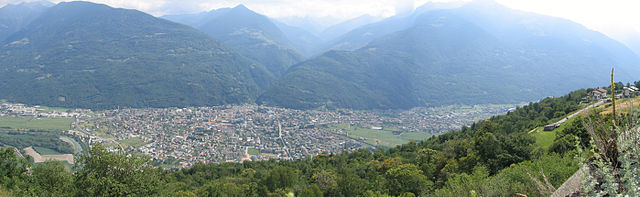
Таламона (Talamona, Talamona)
.svg)
- коммуна Италии
 Hiking in Таламона
Talamona, located in the Sondrio province of Lombardy, Italy, is surrounded by stunning landscapes and mountains, making it an excellent destination for hiking enthusiasts.
Hiking Trails
-
Val Gerola: This area offers several hiking paths that lead through lush valleys and provide breathtaking views of the surrounding peaks. Trails vary in difficulty, suitable for both beginners and experienced hikers.
-
Monte Grezzona: A popular destination for those seeking a more challenging hike, the trail to Monte Grezzona rewards hikers with panoramic views over the Valtellina Valley and the surrounding mountains.
-
Sentiero dei Fiori: A scenic trail that showcases the natural flora of the region. This path is great for those interested in botany and photography, particularly during the spring and summer months when wildflowers are in bloom.
Preparation Tips
- Weather: Check the weather forecast before heading out, as conditions can change rapidly in the mountains.
- Equipment: Wear sturdy hiking boots and consider trekking poles for stability, especially on steeper trails. Always bring plenty of water and snacks.
- Maps and Guides: It’s advisable to carry a detailed map or use a hiking app for navigation, as some trails may not be well-marked.
Local Attractions
- After your hike, consider exploring the charming town of Talamona, where you can enjoy local cuisine, such as polenta and other regional specialties.
- Visit nearby attractions like the San Marco Pass and the beautiful Lake Como, which are perfect for post-hike relaxation and sightseeing.
Safety Considerations
- Always inform someone about your hiking plans.
- Start early in the day to make the most of daylight hours, especially on longer trails.
- Be aware of wildlife and the importance of keeping a safe distance.
Hiking in Talamona offers a unique blend of natural beauty, adventure, and cultural experiences that can be truly rewarding for outdoor enthusiasts. Enjoy your hike!
- Страна:

- Почтовый код: 23018
- Телефонный код: 0342
- Код автомобильного номера: SO
- Координаты: 46° 8' 0" N, 9° 37' 0" E


- GPS треки (wikiloc): [Ссылка]
- Высота над уровнем моря: 285 м m
- Площадь: 21.05 кв.км
- Население: 4671
- Веб сайт: http://www.comune.talamona.so.it
- Википедия русская: wiki(ru)
- Википедия английская: wiki(en)
- Википедия национальная: wiki(it)
- Хранилище Wikidata: Wikidata: Q40880
- Катеория в википедии: [Ссылка]
- код Freebase: [/m/0gj3tn]
- код GeoNames: Альт: [6543124]
- код VIAF: Альт: [240565628]
- ID отношения в OpenStreetMap: [46870]
- UN/LOCODE: [ITTMA]
- код ISTAT: 014063
- кадастровый код Италии: L035
Граничит с регионами:
Тартано
- коммуна Италии
Hiking in Тартано
Tartano is a mountain area located in the Italian Alps, specifically in the Lombardy region. It offers a range of hiking opportunities for both novice and experienced hikers. The region is known for its breathtaking landscapes, including lush forests, alpine meadows, and stunning panoramic views....
- Страна:
- Почтовый код: 23010
- Телефонный код: 0342
- Код автомобильного номера: SO
- Координаты: 46° 7' 0" N, 9° 41' 0" E
- GPS треки (wikiloc): [Ссылка]
- Высота над уровнем моря: 1210 м m
- Площадь: 47.27 кв.км
- Население: 205
- Веб сайт: [Ссылка]


Дацио
- коммуна Италии
Hiking in Дацио
Dazio, a picturesque area located in the northern part of Italy, particularly in the Valtellina valley, offers a variety of hiking opportunities that cater to different skill levels and interests. Here are some key points about hiking in Dazio:...
- Страна:
- Почтовый код: 23010
- Телефонный код: 0342
- Код автомобильного номера: SO
- Координаты: 46° 9' 41" N, 9° 36' 2" E
- GPS треки (wikiloc): [Ссылка]
- Высота над уровнем моря: 568 м m
- Площадь: 3.73 кв.км
- Население: 442
- Веб сайт: [Ссылка]
Арденно
- коммуна Италии
Hiking in Арденно
Ardenno, located in the Valtellina region of northern Italy, offers a beautiful setting for hiking enthusiasts. The area is known for its stunning landscapes, rich flora and fauna, and traditional alpine villages. Here are some key points to consider when hiking in Ardenno:...
- Страна:
- Почтовый код: 23011
- Телефонный код: 0342
- Код автомобильного номера: SO
- Координаты: 46° 10' 0" N, 9° 39' 0" E
- GPS треки (wikiloc): [Ссылка]
- Высота над уровнем моря: 266 м m
- Площадь: 17.14 кв.км
- Население: 3270
- Веб сайт: [Ссылка]

Морбеньо
- коммуна Италии
Hiking in Морбеньо
Morbegno is a charming town in the Valtellina region of northern Italy, nestled among the Alps. It offers a variety of hiking opportunities, suitable for different skill levels, from gentle walks to more challenging treks....
- Страна:
- Почтовый код: 23017
- Телефонный код: 0342
- Код автомобильного номера: SO
- Координаты: 46° 8' 0" N, 9° 34' 0" E
- GPS треки (wikiloc): [Ссылка]
- Высота над уровнем моря: 242 м m
- Площадь: 14.82 кв.км
- Население: 12407
- Веб сайт: [Ссылка]
Форкола
- коммуна Италии
Hiking in Форкола
Forcola, located in the beautiful Lombardy region of Italy, is a scenic destination for hiking enthusiasts. Here are some highlights and details about hiking in the Forcola area:...
- Страна:
- Почтовый код: 23010
- Телефонный код: 0342
- Код автомобильного номера: SO
- Координаты: 46° 9' 0" N, 9° 40' 0" E
- GPS треки (wikiloc): [Ссылка]
- Высота над уровнем моря: 289 м m
- Площадь: 15.9 кв.км
- Население: 796
- Веб сайт: [Ссылка]


Альбаредо-пер-Сан-Марко
- коммуна Италии
Hiking in Альбаредо-пер-Сан-Марко
Albaredo per San Marco is a charming village located in the province of Sondrio, in the Lombardy region of northern Italy. Nestled within the stunning landscapes of the Valtellina Valley and the surrounding Orobie Alps, it offers a range of beautiful hiking opportunities suitable for various skill levels....
- Страна:
- Почтовый код: 23010
- Телефонный код: 0342
- Код автомобильного номера: SO
- Координаты: 46° 6' 11" N, 9° 35' 26" E
- GPS треки (wikiloc): [Ссылка]
- Высота над уровнем моря: 950 м m
- Площадь: 18.96 кв.км
- Население: 300
- Веб сайт: [Ссылка]