Альбаредо-пер-Сан-Марко (Albaredo per San Marco, Albaredo per San Marco)
.svg)
- коммуна Италии
 Hiking in Альбаредо-пер-Сан-Марко
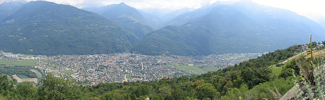
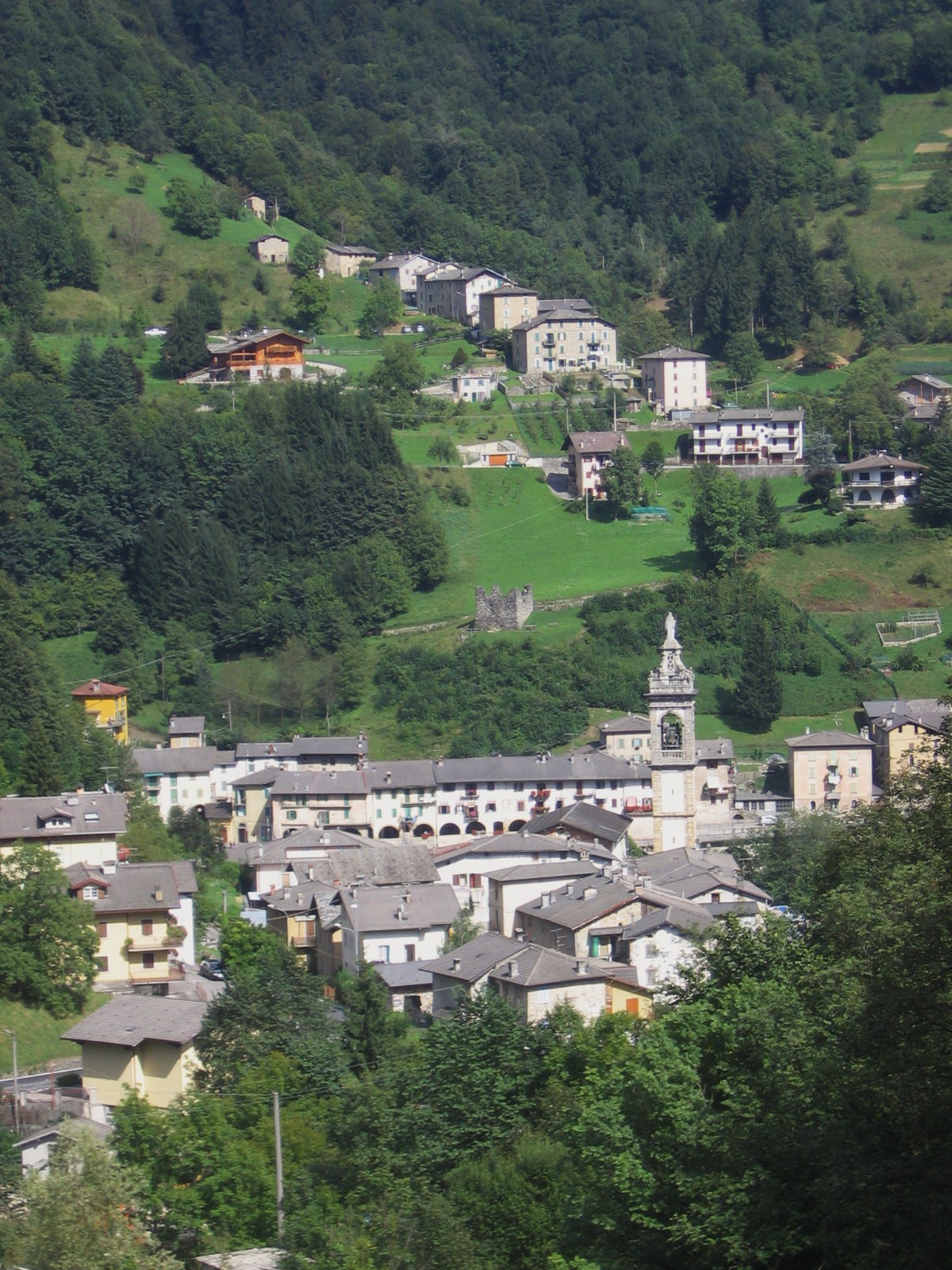
Albaredo per San Marco is a charming village located in the province of Sondrio, in the Lombardy region of northern Italy. Nestled within the stunning landscapes of the Valtellina Valley and the surrounding Orobie Alps, it offers a range of beautiful hiking opportunities suitable for various skill levels.
Hiking Opportunities
-
Scenic Trails: The area is known for its picturesque trails that provide breathtaking views of the surrounding mountains, valleys, and forests. The trails often lead through lush meadows, dense woodlands, and along streams.
-
The Sentiero dei Faggi: This trail is particularly popular for its scenic beauty and is characterized by rich beech forests. It is perfect for a leisurely hike or a family outing.
-
Orobie Alps Regional Park: Located nearby, this park includes a variety of trails and natural features to explore, including alpine lakes and rugged peaks. Hiking here allows you to connect with local flora and fauna.
-
Difficulty Levels: There are hikes available for all levels, from beginner-friendly trails that offer an easy-going experience to more challenging routes for experienced hikers looking for a vigorous adventure.
Practical Information
-
Best Time to Hike: Late spring to early autumn (May to October) is the ideal time for hiking in the area, as the weather is typically mild, and the landscapes are vibrant with greenery and blooming flowers.
-
Local Amenities: Albaredo per San Marco has basic amenities, including accommodations and restaurants, making it a convenient base for hiking excursions.
-
Map and Guidelines: It is advised to carry a local topographic map and to check signage along the trails. Staying on marked paths is crucial to preserve the natural environment and ensure personal safety.
Safety Tips
-
Weather Awareness: Always check the weather before heading out, as conditions can change rapidly in mountainous areas.
-
Gear Up: Proper hiking gear, including sturdy boots, sufficient water, snacks, and a first-aid kit, is essential.
-
Buddy System: If possible, hike with a partner or group for safety.
-
Leave No Trace: Respect the environment by adhering to Leave No Trace principles, ensuring you clean up after yourselves and preserve the natural beauty of the trails.
Whether you are a seasoned hiker or a beginner looking to explore the beautiful Italian Alps, Albaredo per San Marco offers a wonderful opportunity to enjoy nature and experience the tranquility of the great outdoors.
- Страна:

- Почтовый код: 23010
- Телефонный код: 0342
- Код автомобильного номера: SO
- Координаты: 46° 6' 11" N, 9° 35' 26" E


- GPS треки (wikiloc): [Ссылка]
- Высота над уровнем моря: 950 м m
- Площадь: 18.96 кв.км
- Население: 300
- Веб сайт: http://www.vallidelbitto.it/
- Википедия русская: wiki(ru)
- Википедия английская: wiki(en)
- Википедия национальная: wiki(it)
- Хранилище Wikidata: Wikidata: Q40961
- код Freebase: [/m/0gj2f3]
- код GeoNames: Альт: [6536136]
- ID отношения в OpenStreetMap: [46772]
- код ISTAT: 014001
- кадастровый код Италии: A135
- LombardiaBeniCulturali toponym ID: 10000003
Граничит с регионами:


Меццольдо
- коммуна Италии
Hiking in Меццольдо
Mezzoldo is a charming village located in the Lombardy region of Italy, nestled in the Bergamo Alps. It's a wonderful destination for hikers, offering a blend of natural beauty, historical sites, and a variety of trails catering to different skill levels....
- Страна:
- Почтовый код: 24010
- Телефонный код: 0345
- Код автомобильного номера: BG
- Координаты: 46° 0' 47" N, 9° 39' 53" E
- GPS треки (wikiloc): [Ссылка]
- Высота над уровнем моря: 835 м m
- Площадь: 18.84 кв.км
- Население: 161
- Веб сайт: [Ссылка]
Тартано
- коммуна Италии
Hiking in Тартано
Tartano is a mountain area located in the Italian Alps, specifically in the Lombardy region. It offers a range of hiking opportunities for both novice and experienced hikers. The region is known for its breathtaking landscapes, including lush forests, alpine meadows, and stunning panoramic views....
- Страна:
- Почтовый код: 23010
- Телефонный код: 0342
- Код автомобильного номера: SO
- Координаты: 46° 7' 0" N, 9° 41' 0" E
- GPS треки (wikiloc): [Ссылка]
- Высота над уровнем моря: 1210 м m
- Площадь: 47.27 кв.км
- Население: 205
- Веб сайт: [Ссылка]

Морбеньо
- коммуна Италии
Hiking in Морбеньо
Morbegno is a charming town in the Valtellina region of northern Italy, nestled among the Alps. It offers a variety of hiking opportunities, suitable for different skill levels, from gentle walks to more challenging treks....
- Страна:
- Почтовый код: 23017
- Телефонный код: 0342
- Код автомобильного номера: SO
- Координаты: 46° 8' 0" N, 9° 34' 0" E
- GPS треки (wikiloc): [Ссылка]
- Высота над уровнем моря: 242 м m
- Площадь: 14.82 кв.км
- Население: 12407
- Веб сайт: [Ссылка]
Таламона
- коммуна Италии
Hiking in Таламона
Talamona, located in the Sondrio province of Lombardy, Italy, is surrounded by stunning landscapes and mountains, making it an excellent destination for hiking enthusiasts....
- Страна:
- Почтовый код: 23018
- Телефонный код: 0342
- Код автомобильного номера: SO
- Координаты: 46° 8' 0" N, 9° 37' 0" E
- GPS треки (wikiloc): [Ссылка]
- Высота над уровнем моря: 285 м m
- Площадь: 21.05 кв.км
- Население: 4671
- Веб сайт: [Ссылка]
Бема
- коммуна Италии
Hiking in Бема
Bema, located in the Lombardy region of Italy, is a beautiful destination for hiking enthusiasts. Nestled in the mountainous area of the Valtellina valley, it offers stunning views, diverse landscapes, and rich flora and fauna. Here are some highlights and tips for hiking in Bema:...
- Страна:
- Почтовый код: 23010
- Телефонный код: 0342
- Код автомобильного номера: SO
- Координаты: 46° 7' 0" N, 9° 34' 0" E
- GPS треки (wikiloc): [Ссылка]
- Высота над уровнем моря: 800 м m
- Площадь: 19.22 кв.км
- Население: 116
- Веб сайт: [Ссылка]

Аверара
- коммуна Италии
Hiking in Аверара
Averara is a beautiful destination for hiking enthusiasts, nestled in the Bergamo Alps in the Lombardy region of Italy. This picturesque village offers a range of hiking trails suitable for various skill levels, set against the backdrop of stunning mountain scenery, lush forests, and vibrant flora....
- Страна:
- Почтовый код: 24010
- Телефонный код: 0345
- Код автомобильного номера: BG
- Координаты: 45° 59' 20" N, 9° 37' 53" E
- GPS треки (wikiloc): [Ссылка]
- Высота над уровнем моря: 650 м m
- Площадь: 10.69 кв.км
- Население: 178
- Веб сайт: [Ссылка]