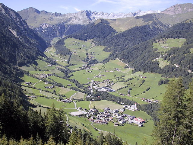
Теренто (Terenten, Terento)
.svg)
- коммуна в Италии
 Hiking in Теренто
Terenten, a picturesque village located in the South Tyrol region of northern Italy, offers stunning landscapes, fresh air, and a variety of hiking trails suitable for all levels of experience. Here are some key points about hiking in Terenten:
Trails and Routes
-
Variety of Trails: Terenten features numerous well-marked trails, ranging from easy walks through meadows to more challenging hikes that lead to higher altitudes. The area is part of the larger Dolomites region, providing breathtaking views.
-
Mountain Hikes: You can explore trails that lead to nearby peaks, such as the Pfannspitze or the Hohe Riffler, which offer panoramic views of the surrounding mountains and valleys.
-
Themed Trails: Some trails in the area focus on particular themes, such as cultural history or nature exploration. This can add depth to your hiking experience as you learn about the local flora, fauna, and culture.
Nature
- Biodiversity: The region is known for its diverse ecosystems. While hiking, you can encounter various wildlife, including deer, chamois, and a variety of bird species, as well as beautiful wildflowers in the summer months.
Accessibility
- Starting Points: The village itself serves as an excellent starting point for many trails, with several routes accessible directly from Terenten. Some routes might require a short transfer by bus or car to trailheads.
Facilities
- Local Amenities: Terenten has accommodations, restaurants, and shops that cater to hikers. You can find local specialties to replenish your energy after a day of hiking.
Best Time to Hike
- Seasons: The best time for hiking in Terenten is during the late spring to early autumn (May to October) when the trails are generally clear of snow and the weather is pleasant. Summer can be warm, so be prepared with adequate water and sun protection.
Safety and Preparation
-
Gear Up: Invest in good hiking shoes, appropriate clothing for varying weather conditions, and carry essentials like a map, first aid kit, and enough food and water.
-
Know Your Limits: Be mindful of your physical condition and experience level, and choose trails that match your ability.
-
Guided Tours: If you're unfamiliar with the area, consider joining a guided tour. Local guides can provide valuable insights into the region’s geology and ecology, as well as ensure your safety on the trails.
Conclusion
Hiking in Terenten offers a unique combination of natural beauty, cultural richness, and accessible trails. Whether you're looking for a leisurely stroll or an intensive hike, Terenten has something to offer every outdoor enthusiast. Always remember to respect nature and leave no trace to help preserve the beauty of the area for future hikers.
- Страна:

- Почтовый код: 39030
- Телефонный код: 0472
- Код автомобильного номера: BZ
- Координаты: 46° 49' 48" N, 11° 46' 58" E


- GPS треки (wikiloc): [Ссылка]
- Высота над уровнем моря: 1210 м m
- Площадь: 42.16 кв.км
- Население: 1753
- Веб сайт: http://www.gemeinde.terenten.bz.it/
- Википедия русская: wiki(ru)
- Википедия английская: wiki(en)
- Википедия национальная: wiki(it)
- Хранилище Wikidata: Wikidata: Q499667
- Галерея изображений в википедии: [Ссылка]
- Катеория в википедии: [Ссылка]
- код Freebase: [/m/0g9j_2]
- код GeoNames: Альт: [6535933]
- код VIAF: Альт: [144325096]
- ID отношения в OpenStreetMap: [47333]
- код GND: Альт: [4119564-4]
- код LCNAF: Альт: [n85380158]
- код ISTAT: 021096
- кадастровый код Италии: L106
Граничит с регионами:

Вандойес
- коммуна в Италии
Hiking in Вандойес
Vintl, or Vintl in German, is a scenic village located in South Tyrol, northern Italy. It's an excellent base for hiking enthusiasts, as the surrounding area offers a variety of trails ranging from easy strolls to challenging mountain hikes....
- Страна:
- Почтовый код: 39030
- Телефонный код: 0472
- Код автомобильного номера: BZ
- Координаты: 46° 48' 54" N, 11° 43' 14" E
- GPS треки (wikiloc): [Ссылка]
- Высота над уровнем моря: 755 м m
- Площадь: 110.82 кв.км
- Население: 3336
- Веб сайт: [Ссылка]


Кьенес
- коммуна Италии
Hiking in Кьенес
Kiens, located in South Tyrol, Italy, is a beautiful destination for hiking enthusiasts. The area is characterized by stunning mountain scenery, lush valleys, and a variety of trails that cater to different skill levels. Here are some highlights of hiking in Kiens:...
- Страна:
- Почтовый код: 39030
- Телефонный код: 0474
- Код автомобильного номера: BZ
- Координаты: 46° 48' 24" N, 11° 50' 24" E
- GPS треки (wikiloc): [Ссылка]
- Высота над уровнем моря: 784 м m
- Площадь: 33.68 кв.км
- Население: 2838
- Веб сайт: [Ссылка]

Сельва-дей-Молини
- коммуна в Италии
Hiking in Сельва-дей-Молини
Mühlwald, located in South Tyrol, Italy, offers beautiful hiking opportunities set against a stunning backdrop of the Eastern Alps. The region is known for its lush landscapes, diverse flora and fauna, and well-marked trails that cater to various skill levels, from easy walks to challenging mountain hikes. Here are some highlights of hiking in Mühlwald:...
- Страна:
- Почтовый код: 39030
- Телефонный код: 0474
- Код автомобильного номера: BZ
- Координаты: 46° 53' 25" N, 11° 51' 30" E
- GPS треки (wikiloc): [Ссылка]
- Высота над уровнем моря: 1229 м m
- Площадь: 104.79 кв.км
- Население: 1437
- Веб сайт: [Ссылка]