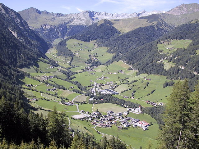
Сельва-дей-Молини (Mühlwald, Selva dei Molini)
.svg)
- коммуна в Италии
 Hiking in Сельва-дей-Молини
Mühlwald, located in South Tyrol, Italy, offers beautiful hiking opportunities set against a stunning backdrop of the Eastern Alps. The region is known for its lush landscapes, diverse flora and fauna, and well-marked trails that cater to various skill levels, from easy walks to challenging mountain hikes. Here are some highlights of hiking in Mühlwald:
1.
- Mühlwalder Tal: This picturesque valley is a great place to start, featuring gentle trails along the river, surrounded by forests and mountain views. It's suitable for families and those seeking a leisurely hike.
- Alpine Trails: For more experienced hikers, there are various trails that lead up to higher altitudes, offering panoramic views of the surrounding peaks.
2.
- The area is rich in biodiversity, and hikers may encounter native wildlife such as chamois, deer, and numerous bird species. The meadows are adorned with vibrant wildflowers, particularly in spring and early summer.
3.
- Along some trails, you may come across traditional alpine huts and farms, providing a glimpse into the region's rich culture and history. Stopping at a local hut can be a great way to enjoy authentic Tyrolean cuisine.
4.
- Summer: The most popular time for hiking, with trails fully accessible and stunning wildflower displays.
- Autumn: The fall foliage provides a breathtaking backdrop, making it a perfect time for photography.
- Winter: Mühlwald also offers opportunities for winter hiking and snowshoeing, allowing you to explore the serene winter landscape.
5.
- Trail Maps: Always carry a trail map or download a hiking app to stay oriented.
- Gear: Proper hiking footwear and clothing suitable for variable weather are essential.
- Water and Snacks: Hydration is key, especially on longer hikes, so pack enough water and energy snacks.
- Respect Nature: Follow the Leave No Trace principles to protect the beautiful environment.
6.
- Consider guided hikes, especially if you're unfamiliar with the area. Local guides can enhance your experience with their knowledge of the terrain and local flora and fauna.
Hiking in Mühlwald offers a fantastic way to immerse yourself in the natural beauty of the South Tyrol region. Whether you are an experienced hiker or just looking for a peaceful nature walk, you’ll find plenty of trails that suit your preferences. Happy hiking!
- Страна:

- Почтовый код: 39030
- Телефонный код: 0474
- Код автомобильного номера: BZ
- Координаты: 46° 53' 25" N, 11° 51' 30" E


- GPS треки (wikiloc): [Ссылка]
- Высота над уровнем моря: 1229 м m
- Площадь: 104.79 кв.км
- Население: 1437
- Веб сайт: http://www.gemeinde.muehlwald.bz.it
- Википедия русская: wiki(ru)
- Википедия английская: wiki(en)
- Википедия национальная: wiki(it)
- Хранилище Wikidata: Wikidata: Q504310
- Галерея изображений в википедии: [Ссылка]
- Катеория в википедии: [Ссылка]
- код Freebase: [/m/0g9jwl]
- код GeoNames: Альт: [6535980]
- код VIAF: Альт: [248306527]
- ID отношения в OpenStreetMap: [47332]
- код GND: Альт: [4997785-4]
- код ISTAT: 021088
- кадастровый код Италии: I593
Граничит с регионами:

Вандойес
- коммуна в Италии
Hiking in Вандойес
Vintl, or Vintl in German, is a scenic village located in South Tyrol, northern Italy. It's an excellent base for hiking enthusiasts, as the surrounding area offers a variety of trails ranging from easy strolls to challenging mountain hikes....
- Страна:
- Почтовый код: 39030
- Телефонный код: 0472
- Код автомобильного номера: BZ
- Координаты: 46° 48' 54" N, 11° 43' 14" E
- GPS треки (wikiloc): [Ссылка]
- Высота над уровнем моря: 755 м m
- Площадь: 110.82 кв.км
- Население: 3336
- Веб сайт: [Ссылка]
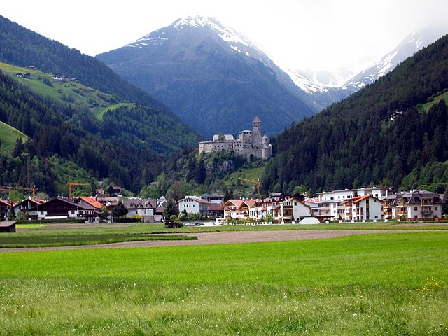

Кампо-Турес
- коммуна Италии
Hiking in Кампо-Турес
Sand in Taufers, or Campo Tures as it is known in Italian, is a picturesque village located in the Ahrntal Valley in South Tyrol, Italy. It's renowned for its stunning natural scenery, rich cultural heritage, and a variety of outdoor activities, particularly hiking. Here are some key points about hiking in this beautiful region:...
- Страна:
- Почтовый код: 39032
- Телефонный код: 0474
- Код автомобильного номера: BZ
- Координаты: 46° 54' 30" N, 11° 57' 37" E
- GPS треки (wikiloc): [Ссылка]
- Высота над уровнем моря: 864 м m
- Площадь: 163.98 кв.км
- Население: 5430
- Веб сайт: [Ссылка]


Кьенес
- коммуна Италии
Hiking in Кьенес
Kiens, located in South Tyrol, Italy, is a beautiful destination for hiking enthusiasts. The area is characterized by stunning mountain scenery, lush valleys, and a variety of trails that cater to different skill levels. Here are some highlights of hiking in Kiens:...
- Страна:
- Почтовый код: 39030
- Телефонный код: 0474
- Код автомобильного номера: BZ
- Координаты: 46° 48' 24" N, 11° 50' 24" E
- GPS треки (wikiloc): [Ссылка]
- Высота над уровнем моря: 784 м m
- Площадь: 33.68 кв.км
- Население: 2838
- Веб сайт: [Ссылка]
Фальцес
- коммуна Италии
Hiking in Фальцес
Pfalzen, also known as Falzes, is a charming village located in South Tyrol, Italy, nestled in the stunning Dolomites region. It offers a variety of hiking opportunities for all levels of hikers, with beautiful landscapes, scenic views, and a rich natural environment....
- Страна:
- Почтовый код: 39030
- Телефонный код: 0474
- Код автомобильного номера: BZ
- Координаты: 46° 48' 49" N, 11° 52' 59" E
- GPS треки (wikiloc): [Ссылка]
- Высота над уровнем моря: 1022 м m
- Площадь: 33.13 кв.км
- Население: 2783
- Веб сайт: [Ссылка]
Валле-Аурина
- коммуна в Италии
Hiking in Валле-Аурина
Ahrntal, also known as the Aurina Valley, is a stunning destination for hiking enthusiasts located in the South Tyrol region of northern Italy. Nestled in the Zillertal Alps, this area is characterized by its breathtaking landscapes, towering peaks, lush meadows, and pristine valleys....
- Страна:
- Почтовый код: 39030
- Телефонный код: 0474
- Код автомобильного номера: BZ
- Координаты: 46° 59' 49" N, 11° 58' 49" E
- GPS треки (wikiloc): [Ссылка]
- Высота над уровнем моря: 1054 м m
- Площадь: 187.89 кв.км
- Население: 5991
- Веб сайт: [Ссылка]

Гайс
- коммуна Италии
Hiking in Гайс
Gais, a picturesque village in South Tyrol, Italy, is an excellent destination for hiking enthusiasts. Nestled in the shadow of the stunning Dolomites, the area offers breathtaking landscapes, diverse trails, and a rich cultural heritage. Here’s an overview of what you can expect while hiking in and around Gais:...
- Страна:
- Почтовый код: 39030
- Телефонный код: 0474
- Код автомобильного номера: BZ
- Координаты: 46° 50' 0" N, 11° 57' 0" E
- GPS треки (wikiloc): [Ссылка]
- Высота над уровнем моря: 841 м m
- Площадь: 60.62 кв.км
- Население: 3279
- Веб сайт: [Ссылка]


Теренто
- коммуна в Италии
Hiking in Теренто
Terenten, a picturesque village located in the South Tyrol region of northern Italy, offers stunning landscapes, fresh air, and a variety of hiking trails suitable for all levels of experience. Here are some key points about hiking in Terenten:...
- Страна:
- Почтовый код: 39030
- Телефонный код: 0472
- Код автомобильного номера: BZ
- Координаты: 46° 49' 48" N, 11° 46' 58" E
- GPS треки (wikiloc): [Ссылка]
- Высота над уровнем моря: 1210 м m
- Площадь: 42.16 кв.км
- Население: 1753
- Веб сайт: [Ссылка]


Валь-ди-Вицце
- коммуна в Италии
Hiking in Валь-ди-Вицце
Pfitsch is a beautiful valley located in South Tyrol, Italy, known for its stunning landscapes, charming villages, and excellent hiking opportunities. The area is part of the larger Stubai Valley and offers a variety of trails suitable for different skill levels, from gentle walks to challenging hikes....
- Страна:
- Почтовый код: 39040
- Телефонный код: 0472
- Код автомобильного номера: BZ
- Координаты: 46° 54' 0" N, 11° 28' 0" E
- GPS треки (wikiloc): [Ссылка]
- Высота над уровнем моря: 948 м m
- Площадь: 142.12 кв.км
- Население: 3071
- Веб сайт: [Ссылка]

Финкенберг
Hiking in Финкенберг
Finkenberg is a picturesque village located in the Zillertal Valley of Tyrol, Austria, known for its stunning alpine scenery and a variety of hiking opportunities. Here are some key points about hiking in Finkenberg:...
- Страна:

- Почтовый код: 6292
- Телефонный код: 05285
- Код автомобильного номера: SZ
- Координаты: 47° 9' 10" N, 11° 49' 18" E
- GPS треки (wikiloc): [Ссылка]
- Высота над уровнем моря: 839 м m
- Площадь: 171.6 кв.км
- Население: 1421
- Веб сайт: [Ссылка]