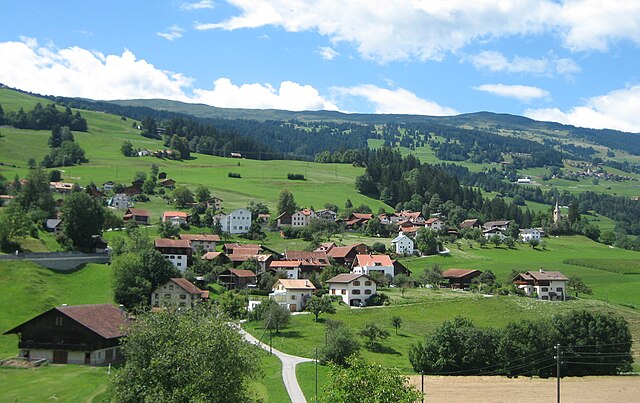
Thusis (Kreis Thusis)

 Hiking in Thusis
Thusis, located in the canton of Graubünden in Switzerland, is an excellent destination for hiking enthusiasts. Nestled in the Rhine Valley and surrounded by the stunning landscapes of the Swiss Alps, the area offers a wide range of trails suitable for various skill levels, from leisurely walks to challenging mountain hikes.
Key Highlights of Hiking in Thusis:
-
Diverse Trails: The hiking routes around Thusis cater to all abilities. You can find easy paths suitable for families and more demanding trails for seasoned hikers. Popular routes include the trails leading to the famous Viamala Gorge and the trails around the picturesque Tamins area.
-
Viamala Gorge: One of the highlight hikes near Thusis is the Viamala Gorge, where hikers can walk along pathways that offer stunning views of the river and the dramatic rock formations. The gorge is accessible and its well-maintained paths allow you to experience the awe of nature.
-
Aussichtsweg Thusis: For panoramic views, the Aussichtsweg offers breathtaking vistas over the Rhine Valley and the surrounding mountains. This trail showcases the landscape's beauty and is a great option for photography.
-
Alpine Flora and Fauna: Hiking in the Thusis area allows for encounters with diverse flora and fauna. Keep an eye out for local wildlife as well as a variety of wildflowers, especially in the spring and summer months.
-
Cultural Experiences: Along many of the trails, you may discover traditional Swiss villages and historical landmarks. This provides a wonderful opportunity to experience the local culture and cuisine.
-
Access and Transport: Thusis is well connected by public transport, making it easy to reach various trailheads. The area has good signage for hiking routes, which helps in navigation.
Tips for Hiking in Thusis:
-
Seasonal Considerations: The best time to hike in Thusis is typically from late spring to early autumn, as winter can bring snow and icy conditions to higher elevations.
-
Appropriate Gear: Always wear appropriate footwear and bring necessary gear, including water, snacks, and a map or a hiking app for navigation.
-
Trail Conditions: Check the local weather and trail conditions before setting out, as the environment can change rapidly in mountainous areas.
-
Local Guidance: If you're unfamiliar with the area, consider joining a guided hike or visiting the local tourism office for recommendations and advice.
Overall, hiking in Thusis offers a unique mix of natural beauty, adventure, and cultural experiences, making it a fantastic destination for anyone looking to explore the great outdoors in Switzerland.
- Страна:

- Площадь: 77.28 кв.км
- Википедия английская: wiki(en)
- Википедия национальная: wiki(de)
- Хранилище Wikidata: Wikidata: Q664541
- Катеория в википедии: [Ссылка]
Включает регионы:


Кацис
Hiking in Кацис
Cazis, located in the beautiful canton of Graubünden in Switzerland, is a fantastic destination for hiking enthusiasts. The region is known for its stunning Alpine scenery, charming villages, and well-maintained hiking trails. Here are some key highlights about hiking in Cazis:...
- Страна:
- Почтовый код: 7408
- Телефонный код: 081
- Код автомобильного номера: GR
- Координаты: 46° 44' 14" N, 9° 25' 36" E


- GPS треки (wikiloc): [Ссылка]
- Высота над уровнем моря: 633 м m
- Площадь: 31.18 кв.км
- Население: 2174
- Веб сайт: [Ссылка]
Флерден
Hiking in Флерден
Flerden is a small village located in the scenic Swiss region of Graubünden. It's an ideal destination for hiking enthusiasts looking to explore the beautiful landscapes of the Swiss Alps. Here are some highlights and tips for hiking in and around Flerden:...
- Страна:
- Почтовый код: 7426
- Телефонный код: 081
- Код автомобильного номера: GR
- Координаты: 46° 41' 39" N, 9° 23' 33" E
- GPS треки (wikiloc): [Ссылка]
- Высота над уровнем моря: 1408 м m
- Площадь: 6.09 кв.км
- Население: 254
- Веб сайт: [Ссылка]


Урмайн
Hiking in Урмайн
Urmein, located in the Graubünden region of Switzerland, is an idyllic destination for hiking enthusiasts. Nestled amidst stunning alpine scenery, it offers a mix of easy walks and challenging trails suitable for various skill levels. Here are some highlights and tips for hiking in Urmein:...
- Страна:
- Почтовый код: 7427
- Телефонный код: 081
- Код автомобильного номера: GR
- Координаты: 46° 41' 9" N, 9° 24' 7" E
- GPS треки (wikiloc): [Ссылка]
- Высота над уровнем моря: 1189 м m
- Площадь: 4.33 кв.км
- Население: 146

Мазайн
Hiking in Мазайн
Masein, which is part of the more expansive region in Myanmar (Burma), offers a blend of lush landscapes, cultural richness, and opportunities for adventurous hiking. Here are some key highlights:...
- Страна:
- Почтовый код: 7425
- Телефонный код: 081
- Код автомобильного номера: GR
- Координаты: 46° 41' 50" N, 9° 25' 23" E
- GPS треки (wikiloc): [Ссылка]
- Высота над уровнем моря: 942 м m
- Площадь: 4.2 кв.км
- Население: 481
- Веб сайт: [Ссылка]


Чаппина
Hiking in Чаппина
Tschappina, a small village located in the Graubünden region of Switzerland, is a great spot for hiking enthusiasts. Nestled in the beautiful Alps, it offers a variety of trails that cater to different skill levels and preferences. Here’s what you can expect when hiking in Tschappina:...
- Страна:
- Почтовый код: 7428
- Телефонный код: 081
- Код автомобильного номера: GR
- Координаты: 46° 40' 36" N, 9° 21' 38" E
- GPS треки (wikiloc): [Ссылка]
- Высота над уровнем моря: 1699 м m
- Площадь: 24.67 кв.км
- Население: 129
- Веб сайт: [Ссылка]


Тузис
Hiking in Тузис
Thusis, located in the canton of Graubünden in Switzerland, is a great destination for hikers. It sits at the confluence of the Rhine and Hinterrhein rivers and offers stunning views of the surrounding mountains and valleys....
- Страна:
- Почтовый код: 7430
- Телефонный код: 081
- Код автомобильного номера: GR
- Координаты: 46° 41' 19" N, 9° 25' 58" E
- GPS треки (wikiloc): [Ссылка]
- Высота над уровнем моря: 805 м m
- Площадь: 6.81 кв.км
- Население: 3138
- Веб сайт: [Ссылка]