Тузис (Thusis, Thusis)

 Hiking in Тузис
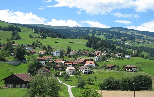
Thusis, located in the canton of Graubünden in Switzerland, is a great destination for hikers. It sits at the confluence of the Rhine and Hinterrhein rivers and offers stunning views of the surrounding mountains and valleys.
Key Hiking Trails in and around Thusis:
-
Via Augusta: This ancient Roman trade route can be explored through various segments. It provides a blend of history and scenic landscapes as you walk along this significant historical path.
-
Ruinaulta (Grand Canyon of Switzerland): The hike around the Ruinaulta region offers breathtaking views of a spectacular canyon carved by the Rhine River. You can choose different routes, ranging from easy to more challenging, with opportunities for photography and enjoying nature.
-
Alp Flix: For a more rustic experience, the hike to Alp Flix provides a moderate trek through lush meadows, forests, and offers picturesque alpine views. It's a beautiful area to explore in summer.
-
Glaris and Piz Beverin: For a more strenuous hike, consider going towards Piz Beverin. The ascent rewards you with panoramic views of the surrounding Alps, but ensure you're prepared with the right gear and sufficient water and food.
-
Waldzhorn: This is another great hiking option that offers picturesque landscapes and a relatively easy trail, making it suitable for families.
Tips for Hiking in Thusis:
-
Season: The best time for hiking is typically from late spring through early autumn (May to October). Check local weather conditions before heading out.
-
Equipment: Wear appropriate hiking shoes and carry a light backpack with water, snacks, a first-aid kit, and a map or GPS device.
-
Local Maps & Apps: Utilize local hiking maps or apps that provide detailed trail information and conditions.
-
Respect Nature: Stay on marked trails to protect local flora and fauna, and practice Leave No Trace principles.
-
Acclimatization: If you're hiking at higher altitudes, take time to acclimatize to avoid altitude sickness.
Thusis is an excellent base for exploring the numerous hiking opportunities in the region, accommodating both novices and experienced hikers. Make sure to enjoy the unique alpine scenery as you trek through this beautiful part of Switzerland!
- Страна:

- Почтовый код: 7430
- Телефонный код: 081
- Код автомобильного номера: GR
- Координаты: 46° 41' 19" N, 9° 25' 58" E


- GPS треки (wikiloc): [Ссылка]
- Высота над уровнем моря: 805 м m
- Площадь: 6.81 кв.км
- Население: 3138
- Веб сайт: http://www.thusis.ch
- Википедия русская: wiki(ru)
- Википедия английская: wiki(en)
- Википедия национальная: wiki(de)
- Хранилище Wikidata: Wikidata: Q66171
- Катеория в википедии: [Ссылка]
- код Freebase: [/m/026g1c8]
- код GeoNames: Альт: [7287310]
- код VIAF: Альт: [239501314]
- ID отношения в OpenStreetMap: [1684187]
- код GND: Альт: [4136595-1]
- идентификатор местоположения ArchINFORM: [3920]
- идентификатор HDS: [1492]
- код швейцарского муниципалитета: [3668]
Граничит с регионами:


Кацис
Hiking in Кацис
Cazis, located in the beautiful canton of Graubünden in Switzerland, is a fantastic destination for hiking enthusiasts. The region is known for its stunning Alpine scenery, charming villages, and well-maintained hiking trails. Here are some key highlights about hiking in Cazis:...
- Страна:
- Почтовый код: 7408
- Телефонный код: 081
- Код автомобильного номера: GR
- Координаты: 46° 44' 14" N, 9° 25' 36" E
- GPS треки (wikiloc): [Ссылка]
- Высота над уровнем моря: 633 м m
- Площадь: 31.18 кв.км
- Население: 2174
- Веб сайт: [Ссылка]


Фюрстенау
Hiking in Фюрстенау
Fürstenau, located in the Swiss canton of Graubünden, is a charming village that offers a range of beautiful hiking opportunities amidst the stunning landscapes of the Swiss Alps. Here’s what you need to know about hiking in this area:...
- Страна:
- Почтовый код: 7414
- Телефонный код: 081
- Код автомобильного номера: GR
- Координаты: 46° 42' 59" N, 9° 26' 0" E
- GPS треки (wikiloc): [Ссылка]
- Высота над уровнем моря: 650 м m
- Площадь: 1.32 кв.км
- Население: 349
- Веб сайт: [Ссылка]


Урмайн
Hiking in Урмайн
Urmein, located in the Graubünden region of Switzerland, is an idyllic destination for hiking enthusiasts. Nestled amidst stunning alpine scenery, it offers a mix of easy walks and challenging trails suitable for various skill levels. Here are some highlights and tips for hiking in Urmein:...
- Страна:
- Почтовый код: 7427
- Телефонный код: 081
- Код автомобильного номера: GR
- Координаты: 46° 41' 9" N, 9° 24' 7" E
- GPS треки (wikiloc): [Ссылка]
- Высота над уровнем моря: 1189 м m
- Площадь: 4.33 кв.км
- Население: 146

Мазайн
Hiking in Мазайн
Masein, which is part of the more expansive region in Myanmar (Burma), offers a blend of lush landscapes, cultural richness, and opportunities for adventurous hiking. Here are some key highlights:...
- Страна:
- Почтовый код: 7425
- Телефонный код: 081
- Код автомобильного номера: GR
- Координаты: 46° 41' 50" N, 9° 25' 23" E
- GPS треки (wikiloc): [Ссылка]
- Высота над уровнем моря: 942 м m
- Площадь: 4.2 кв.км
- Население: 481
- Веб сайт: [Ссылка]


Зильс-им-Домлешг
Hiking in Зильс-им-Домлешг
Sils im Domleschg is a picturesque village located in the Graubünden region of Switzerland, known for its stunning natural landscapes and outdoor activities, including hiking. Here are some highlights and considerations for hiking in this area:...
- Страна:
- Почтовый код: 7411
- Телефонный код: 081
- Код автомобильного номера: GR
- Координаты: 46° 42' 0" N, 9° 26' 59" E
- GPS треки (wikiloc): [Ссылка]
- Высота над уровнем моря: 1199 м m
- Площадь: 9.28 кв.км
- Население: 930
- Веб сайт: [Ссылка]


Ронгеллен
Hiking in Ронгеллен
Rongellen is a beautiful area nestled in nature, ideal for hiking enthusiasts. Located in Switzerland, it offers a mix of scenic trails, diverse landscapes, and varying levels of difficulty suitable for hikers of all skill levels....
- Страна:
- Почтовый код: 7430
- Телефонный код: 081
- Код автомобильного номера: GR
- Координаты: 46° 40' 26" N, 9° 26' 26" E
- GPS треки (wikiloc): [Ссылка]
- Высота над уровнем моря: 1074 м m
- Площадь: 2.02 кв.км
- Население: 53
- Веб сайт: [Ссылка]


Лон
Hiking in Лон
Lohn is a picturesque village in the Graubünden region of Switzerland, known for its stunning alpine scenery and outdoor recreational opportunities. It lies at an elevation of about 1,300 meters, making it an excellent base for various hiking trails that cater to different skill levels....
- Страна:
- Почтовый код: 7433
- Телефонный код: 081
- Код автомобильного номера: GR
- Координаты: 46° 39' 5" N, 9° 25' 39" E
- GPS треки (wikiloc): [Ссылка]
- Высота над уровнем моря: 1817 м m
- Площадь: 8.17 кв.км
- Население: 42
- Веб сайт: [Ссылка]