Тиницонг-Рона (Tinizong-Rona, Tinizong-Rona)

 Hiking in Тиницонг-Рона
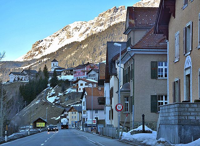
Tinizong-Rona is a beautiful area located in the canton of Graubünden in Switzerland, known for its stunning landscapes and rich natural biodiversity. Hiking in this region offers a plethora of trails suitable for various skill levels, ranging from beginners to advanced hikers. Here's an overview of what you can expect when hiking in Tinizong-Rona:
Hiking Trails
-
Scenic Routes: The area is dotted with well-marked trails that showcase the breathtaking alpine scenery, including pastures, forests, and mountain views. Popular routes may take you to nearby peaks or through picturesque valleys.
-
Mountain Peaks: There are several challenging hikes that lead to higher elevations, where you can enjoy panoramic views of the surrounding mountains and valleys.
-
Easy Hikes: If you're looking for something less strenuous, there are gentle paths ideal for families and casual hikers. These trails often have beautiful flora and are perfect for leisurely walks.
Duration and Difficulty
- Varied Lengths: Trails can range from short walks (1-2 hours) to all-day hikes (5-8 hours). Always check the estimated times and difficulty levels before starting.
- Difficult Terrain: Some trails may involve steep ascents or rocky paths, so it's essential to assess your fitness level and experience before embarking on challenging hikes.
Best Times to Hike
- Summer Months: The best time for hiking in Tinizong-Rona is typically from late June to September when the weather is warm and trails are snow-free.
- Autumn: Early fall provides stunning foliage, making this a picturesque time to explore the area.
Equipment and Safety
- Footwear: Good hiking boots are essential for providing the necessary support and grip on uneven terrains.
- Maps and Navigation: While trails are generally well-marked, carrying a map or GPS device is advisable, especially for longer treks.
- Weather Preparedness: The weather can change rapidly in the mountains, so always be prepared with layers, rain gear, and enough water and snacks.
Local Highlights
- Wildlife: Keep an eye out for local wildlife, including chamois and various bird species. The area is also rich in plant life.
- Cultural Sites: Depending on your route, you may come across charming villages and traditional Swiss architecture that add to the cultural experience of your hike.
Access
- Transportation: Tinizong-Rona is accessible by public transport and has parking facilities. Local buses can often take you closer to trailheads.
Conclusion
Hiking in Tinizong-Rona can be a rewarding experience surrounded by nature's beauty. Whether you're looking for a casual stroll or a challenging mountain ascent, this region offers something for everyone. Always remember to respect nature and leave no trace as you enjoy the trails!
- Страна:

- Почтовый код: 7453
- Телефонный код: 081
- Код автомобильного номера: GR
- Координаты: 46° 35' 0" N, 9° 37' 0" E


- GPS треки (wikiloc): [Ссылка]
- Высота над уровнем моря: 1232 м m
- Площадь: 54.30 кв.км
- Википедия русская: wiki(ru)
- Википедия английская: wiki(en)
- Википедия национальная: wiki(de)
- Хранилище Wikidata: Wikidata: Q65640
- Катеория в википедии: [Ссылка]
- код Freebase: [/m/026fzqq]
- код GeoNames: Альт: [7287312]
- код VIAF: Альт: [314890513]
- идентификатор HDS: [45864]
- код швейцарского муниципалитета: [3541]
- код Цифрового атласа Римской империи: [10787]
Включает регионы:
Rona
Hiking in Rona
Rona, located in Greece (often referred to as Rona GR), is not a widely known hiking destination, but Greece is famous for its diverse landscapes and stunning trails. If you're looking for hiking opportunities in Greece, there are several regions and trails that offer beautiful scenery, rich history, and unique experiences....
- Страна:
- Координаты: 46° 33' 39" N, 9° 37' 29" E
- GPS треки (wikiloc): [Ссылка]
- Высота над уровнем моря: 1408 м m

Tinizong
Hiking in Tinizong
Tinizong, located in the canton of Graubünden in Switzerland, is a beautiful region that offers a range of hiking opportunities for outdoor enthusiasts. Nestled in the Alps, Tinizong provides stunning views, diverse landscapes, and well-marked trails suitable for various skill levels....
- Страна:
- Почтовый код: 7453
- Координаты: 46° 35' 0" N, 9° 37' 0" E
- GPS треки (wikiloc): [Ссылка]
- Высота над уровнем моря: 1232 м m