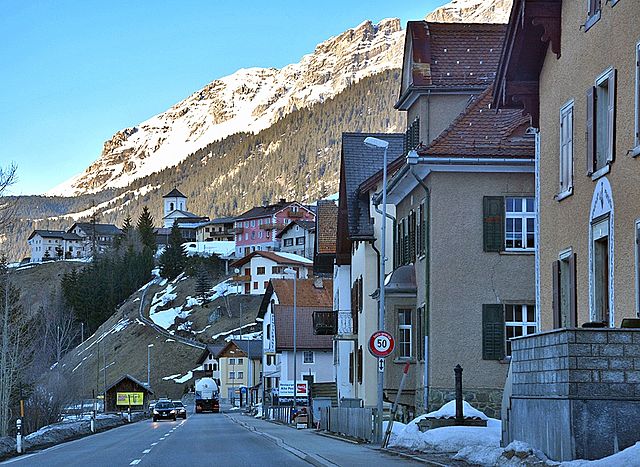
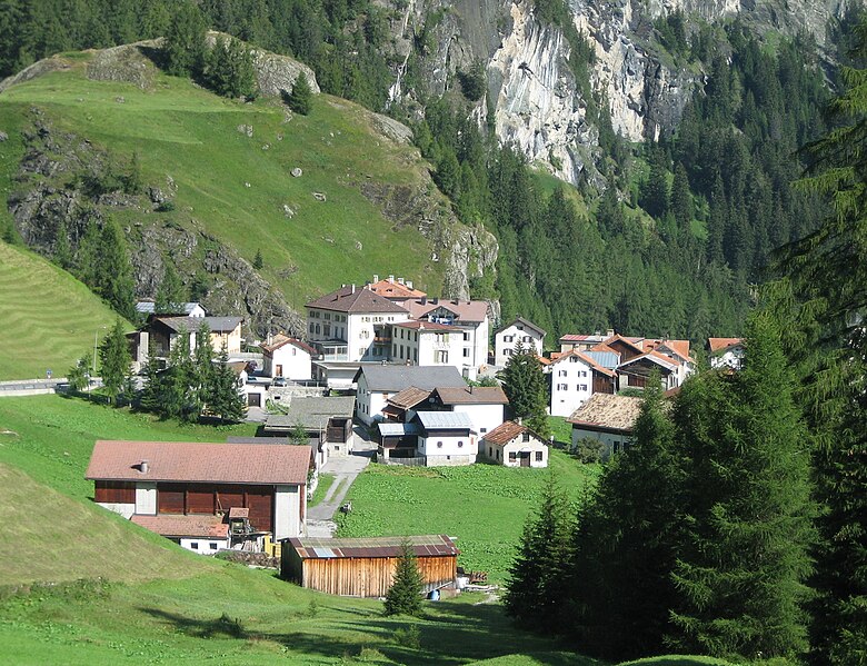
Surses subdistrict (Kreis Surses)
 Hiking in Surses subdistrict
Kreis Surses, located in the Graubünden region of Switzerland, offers a stunning array of hiking opportunities amidst breathtaking landscapes. This area is characterized by its picturesque valleys, lush forests, and majestic alpine scenery, making it perfect for both casual walkers and seasoned hikers.
Popular Hiking Trails:
-
Albula Valley: Explore the trails along the Albula River, where you'll find scenic routes that vary in difficulty. The hike from Filisur to Bergün is particularly popular, showcasing beautiful views and charming villages.
-
Piz Corvatsch: For those seeking a more challenging hike, the path up to Piz Corvatsch offers panoramic views of the surrounding peaks and lakes. This trail requires good fitness levels and appropriate hiking gear.
-
Surses Nature Trail: This family-friendly trail winds through diverse terrains and provides educational signage about the local flora and fauna. It's a great way to introduce children to the joys of hiking.
-
Lake Parpaner Rothorn: A scenic hike that leads to the top of Rothorn, where you can enjoy breathtaking views of the surrounding landscape and lakes, making it perfect for photography enthusiasts.
Tips for Hiking in Kreis Surses:
- Weather Awareness: Always check the weather conditions before heading out, as mountain weather can change rapidly.
- Equipment: Wear appropriate hiking boots and carry sufficient water and snacks. A map or GPS device is recommended for navigation.
- Respect Wildlife: Local wildlife can be sensitive, so keep your distance and follow guidelines to minimize your impact on the environment.
- Trail Conditions: Before setting off, check the local trail status, as some routes may be affected by snowfall or maintenance work.
Best Time to Hike:
The best time to hike in Kreis Surses extends from late spring to early autumn, typically from June to October, when the weather is milder and trails are more accessible.
Kreis Surses offers a unique blend of challenging hikes and serene landscapes, making it a fantastic destination for outdoor enthusiasts. Whether you're looking for a leisurely walk or a rigorous trek, you'll find plenty to enjoy in this beautiful Swiss region.
- Страна:

- Координаты: 46° 36' 0" N, 9° 36' 0" E


- GPS треки (wikiloc): [Ссылка]
- Хранилище Wikidata: Wikidata: Q661691
- Катеория в википедии: [Ссылка]
- LIR: [2756]
Включает регионы:


Кунтер
Hiking in Кунтер
Cunter, a small village in the Grisons region of Switzerland, is an excellent destination for hiking enthusiasts. Nestled amidst stunning landscapes, the area offers a variety of trails suitable for different skill levels, from leisurely walks to more challenging hikes....
- Страна:
- Почтовый код: 7452
- Телефонный код: 081
- Код автомобильного номера: GR
- Координаты: 46° 35' 59" N, 9° 34' 59" E
- GPS треки (wikiloc): [Ссылка]
- Высота над уровнем моря: 1182 м m
- Площадь: 7.12 кв.км
- Население: 215
- Веб сайт: [Ссылка]


Сур
Hiking in Сур
Sur is a charming village located in the Swiss canton of Grisons (Graubünden) and offers impressive hiking opportunities, primarily for those who love the beautiful landscapes of the Swiss Alps. Here’s an overview of what you can expect:...
- Страна:
- Почтовый код: 7456
- Телефонный код: 081
- Код автомобильного номера: GR
- Координаты: 46° 30' 59" N, 9° 36' 59" E
- GPS треки (wikiloc): [Ссылка]
- Высота над уровнем моря: 1530 м m
- Площадь: 23.22 кв.км
- Веб сайт: [Ссылка]


Савоньин
Hiking in Савоньин
Savognin is a picturesque village located in the Surses valley of the Swiss Alps, and it's a fantastic destination for hiking enthusiasts. The region offers a variety of trails that cater to different skill levels, from easy walks suitable for families to more challenging hikes for seasoned adventurers....
- Страна:
- Почтовый код: 7460
- Телефонный код: 081
- Код автомобильного номера: GR
- Координаты: 46° 34' 53" N, 9° 36' 8" E
- GPS треки (wikiloc): [Ссылка]
- Высота над уровнем моря: 1453 м m
- Площадь: 22.24 кв.км
- Веб сайт: [Ссылка]


Марморера
Hiking in Марморера
Marmorera is a picturesque area located in the canton of Graubünden in Switzerland, known for its stunning landscapes, diverse hiking trails, and tranquil atmosphere. Here are some key points to consider if you're planning to hike in Marmorera:...
- Страна:
- Почтовый код: 7456
- Телефонный код: 081
- Код автомобильного номера: GR
- Координаты: 46° 29' 59" N, 9° 39' 0" E
- GPS треки (wikiloc): [Ссылка]
- Высота над уровнем моря: 1720 м m
- Площадь: 18.90 кв.км
- Веб сайт: [Ссылка]


Риом-Парсонц
Hiking in Риом-Парсонц
Riom-Parsonz is a picturesque village located in the canton of Graubünden in Switzerland, known for its stunning natural scenery and excellent hiking opportunities. The region offers a combination of lush valleys, alpine meadows, and striking mountain views, making it a fantastic destination for hikers of all levels....
- Страна:
- Почтовый код: 7464; 7463
- Телефонный код: 081
- Код автомобильного номера: GR
- Координаты: 46° 35' 59" N, 9° 33' 59" E
- GPS треки (wikiloc): [Ссылка]
- Высота над уровнем моря: 1257 м m
- Площадь: 55.97 кв.км
- Веб сайт: [Ссылка]

Тиницонг-Рона
Hiking in Тиницонг-Рона
Tinizong-Rona is a beautiful area located in the canton of Graubünden in Switzerland, known for its stunning landscapes and rich natural biodiversity. Hiking in this region offers a plethora of trails suitable for various skill levels, ranging from beginners to advanced hikers. Here's an overview of what you can expect when hiking in Tinizong-Rona:...
- Страна:
- Почтовый код: 7453
- Телефонный код: 081
- Код автомобильного номера: GR
- Координаты: 46° 35' 0" N, 9° 37' 0" E
- GPS треки (wikiloc): [Ссылка]
- Высота над уровнем моря: 1232 м m
- Площадь: 54.30 кв.км

Мулегнс
Hiking in Мулегнс
Mulegns, a picturesque village nestled in the Swiss Alps, offers fantastic hiking opportunities for outdoor enthusiasts. It is known for its stunning alpine scenery, lush meadows, and well-marked trails suitable for various skill levels. Here are some highlights of hiking in Mulegns:...
- Страна:
- Почтовый код: 7455
- Телефонный код: 081
- Код автомобильного номера: GR
- Координаты: 46° 30' 16" N, 9° 34' 46" E
- GPS треки (wikiloc): [Ссылка]
- Высота над уровнем моря: 1952 м m
- Площадь: 33.79 кв.км


Залуф
Hiking in Залуф
Salouf is a picturesque village located in the Swiss canton of Graubünden, nestled in the scenic Surselva region. The area is renowned for its stunning landscapes, beautiful alpine meadows, and an array of hiking trails suitable for all levels of hikers. Here are some highlights and tips for hiking in Salouf:...
- Страна:
- Почтовый код: 7462
- Телефонный код: 081
- Код автомобильного номера: GR
- Координаты: 46° 37' 27" N, 9° 34' 32" E
- GPS треки (wikiloc): [Ссылка]
- Высота над уровнем моря: 2109 м m
- Площадь: 31.49 кв.км
- Веб сайт: [Ссылка]


Бивио
Hiking in Бивио
Bivio is a charming village located in the Swiss Alps, known for its stunning natural landscapes and excellent hiking opportunities. Situated at the junction of several hiking trails, Bivio serves as a gateway to the surrounding mountains and valleys, making it a popular destination for outdoor enthusiasts....
- Страна:
- Почтовый код: 7457
- Телефонный код: 081
- Код автомобильного номера: GR
- Координаты: 46° 28' 11" N, 9° 39' 4" E
- GPS треки (wikiloc): [Ссылка]
- Высота над уровнем моря: 1769 м m
- Площадь: 76.73 кв.км
- Веб сайт: [Ссылка]