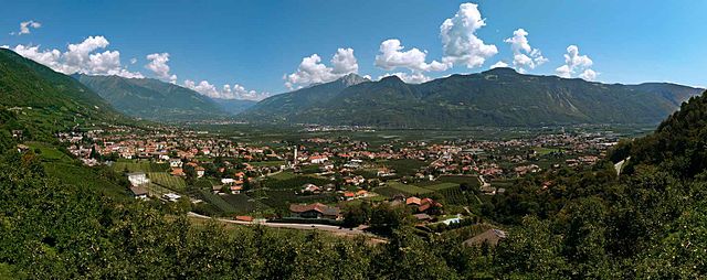
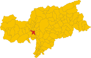
Тезимо (Tisens, Tesimo)
.svg)
- коммуна в Италии
 Hiking in Тезимо
Tisens, a charming village located in South Tyrol, Italy, is a fantastic destination for hiking enthusiasts. Nestled in the mountains near Merano, it offers a variety of stunning trails that cater to different skill levels. Here’s what you can expect from hiking in Tisens:
Scenic Trails
- Various Terrain: The region boasts diverse landscapes, from gentle valleys to steeper mountain paths, providing opportunities for all levels of hikers.
- Panoramic Views: Many trails offer breathtaking views of the surrounding mountains, vineyards, and apple orchards typical of the South Tyrol region.
Popular Hiking Routes
- Tisens - Vöran: This route provides a beautiful combination of forest trails and meadows, perfect for leisurely walks.
- The Waalweg Trail: Known for its easy paths along historic irrigation channels, this trail delivers scenic vistas without being too strenuous.
- Mendel Pass: A moderately challenging hike that rewards trekkers with stunning viewpoints and a chance to explore unique flora and fauna.
Tips for Hiking in Tisens
- Best Time to Go: Spring and early autumn offer the best temperatures and landscapes.
- Gear: Make sure to wear sturdy hiking boots and bring layers, as mountain weather can change quickly.
- Hydration and Snacks: Always carry enough water and snacks, especially on longer hikes.
Local Advice
- Guided Tours: Consider joining a local guide for a more in-depth experience, where you can learn about the region’s history and ecology.
- Nearby Attractions: After your hike, explore Merano, known for its beautiful gardens and charming town center.
Overall, Tisens provides a wonderful hiking experience set against a backdrop of stunning natural beauty, making it an excellent choice for both casual walkers and serious hikers alike.
- Страна:

- Почтовый код: 39010
- Телефонный код: 0473
- Код автомобильного номера: BZ
- Координаты: 46° 33' 56" N, 11° 10' 10" E


- GPS треки (wikiloc): [Ссылка]
- Высота над уровнем моря: 635 м m
- Площадь: 38.13 кв.км
- Население: 1979
- Веб сайт: http://www.gemeinde.tisens.bz.it/
- Википедия русская: wiki(ru)
- Википедия английская: wiki(en)
- Википедия национальная: wiki(it)
- Хранилище Wikidata: Wikidata: Q504459
- Галерея изображений в википедии: [Ссылка]
- Катеория в википедии: [Ссылка]
- код Freebase: [/m/0g9k0_]
- код GeoNames: Альт: [6535935]
- код VIAF: Альт: [242321221]
- ID отношения в OpenStreetMap: [47254]
- код GND: Альт: [4997786-6]
- код Цифрового атласа Римской империи: [16596]
- код ISTAT: 021099
- кадастровый код Италии: L149
Граничит с регионами:


Гаргаццоне
- коммуна Италии
Hiking in Гаргаццоне
Gargazon, located in the South Tyrol region of northern Italy, is a wonderful area for hiking enthusiasts. The region is characterized by its stunning landscapes, which include lush forests, rolling hills, and picturesque views of the surrounding mountains, including the Dolomites. Here are some key points about hiking in Gargazon:...
- Страна:
- Почтовый код: 39010
- Телефонный код: 0473
- Код автомобильного номера: BZ
- Координаты: 46° 35' 4" N, 11° 12' 6" E
- GPS треки (wikiloc): [Ссылка]
- Высота над уровнем моря: 267 м m
- Площадь: 4.91 кв.км
- Население: 1688
- Веб сайт: [Ссылка]
Лана
- коммуна Италии
Hiking in Лана
Lana, located in South Tyrol, Italy, is a fantastic destination for hiking enthusiasts, offering a diverse range of trails set against stunning alpine scenery. Nestled near the larger town of Merano, Lana provides access to beautiful landscapes, charming villages, and cultural sites....
- Страна:
- Почтовый код: 39011
- Телефонный код: 0473
- Код автомобильного номера: BZ
- Координаты: 46° 37' 0" N, 11° 10' 0" E
- GPS треки (wikiloc): [Ссылка]
- Высота над уровнем моря: 310 м m
- Площадь: 36.12 кв.км
- Население: 12286
- Веб сайт: [Ссылка]


Наллес
- коммуна Италии
Hiking in Наллес
Nals, located in South Tyrol, Italy, is a great destination for hiking enthusiasts. Nestled in the picturesque Adige Valley near Bolzano, Nals offers a mix of scenic trails, stunning alpine views, and the unique charm of vineyards and orchards....
- Страна:
- Почтовый код: 39010
- Телефонный код: 0471
- Код автомобильного номера: BZ
- Координаты: 46° 32' 36" N, 11° 12' 22" E
- GPS треки (wikiloc): [Ссылка]
- Высота над уровнем моря: 321 м m
- Площадь: 12.24 кв.км
- Население: 1975
- Веб сайт: [Ссылка]


Сенале-Сан-Феличе
- коммуна в Италии
Hiking in Сенале-Сан-Феличе
Unsere Liebe Frau im Walde-St. Felix is a picturesque village located in the South Tyrol region of Italy, surrounded by stunning natural scenery, making it a fantastic destination for hiking enthusiasts. The area is characterized by its beautiful landscapes, including rolling hills, dense forests, and majestic mountains, providing a diverse range of hiking opportunities for all skill levels....
- Страна:
- Почтовый код: 39010
- Телефонный код: 0463
- Код автомобильного номера: BZ
- Координаты: 46° 29' 39" N, 11° 7' 49" E
- GPS треки (wikiloc): [Ссылка]
- Высота над уровнем моря: 1315 м m
- Площадь: 27.63 кв.км
- Население: 769
- Веб сайт: [Ссылка]


Сан-Панкрацио
- коммуна в Италии
Hiking in Сан-Панкрацио
St. Pankraz, located in the picturesque region of South Tyrol in Italy, offers a range of hiking opportunities for outdoor enthusiasts of all levels. Here are some key highlights about hiking in St. Pankraz:...
- Страна:
- Почтовый код: 39010
- Телефонный код: 0473
- Код автомобильного номера: BZ
- Координаты: 46° 35' 10" N, 11° 5' 9" E
- GPS треки (wikiloc): [Ссылка]
- Высота над уровнем моря: 735 м m
- Площадь: 63.17 кв.км
- Население: 1549
- Веб сайт: [Ссылка]