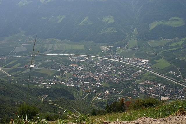
Лана (Lana, Lana)
.svg)
- коммуна Италии
 Hiking in Лана
Lana, located in South Tyrol, Italy, is a fantastic destination for hiking enthusiasts, offering a diverse range of trails set against stunning alpine scenery. Nestled near the larger town of Merano, Lana provides access to beautiful landscapes, charming villages, and cultural sites.
Hiking Highlights in Lana:
-
Variety of Trails: Lana boasts a wide range of hiking trails suitable for different skill levels, from easy walks to more challenging hikes. You can find leisurely paths that meander through vineyards and orchards, as well as more demanding routes that lead into the surrounding mountain ranges.
-
Scenic Views: Many trails offer breathtaking views of the nearby Merano Valley, the Alps, and the surrounding natural beauty. Look out for panoramic viewpoints along the routes, where you can pause to take in the scenery.
-
Hiking to Hohe Wart: One popular hike is the trail leading to the summit of Hohe Wart. The ascent offers stunning vistas and a rewarding sense of achievement. The trail is well-marked, making it accessible for intermediate hikers.
-
Vineyard Trails: The area is known for its wine production, particularly for white wines. You can enjoy walks through vineyards, where you can also learn about local viticulture and perhaps even stop for tastings at a winery along the route.
-
Family-Friendly Options: There are many paths suitable for families with children, featuring gentle slopes and interesting stops along the way, including playgrounds and picnic areas.
-
Cultural Sites: While hiking in Lana, you can also explore local history and architecture, such as the medieval churches and charming town center. Some hikes may take you to historical landmarks or offer guided tours that combine hiking with cultural education.
-
Best Seasons: The best time for hiking in Lana is typically late spring through early autumn (May to September) when the weather is mild, and the trails are well-maintained. However, autumn is also a beautiful time to visit, as the foliage changes colors.
Preparation Tips:
- Gear: Wear sturdy hiking boots, and bring plenty of water, snacks, and sunscreen. A trekking pole can be helpful for steeper sections.
- Maps and Navigation: While many trails are well-marked, having a map or a GPS app can be beneficial, especially for less popular routes.
- Weather Awareness: Always check the weather forecast before heading out, as conditions can change rapidly in the mountains.
Getting There:
Lana is easily accessible from Merano and Bolzano by public transport. There are also several parking areas for those who choose to drive. Once in the area, public transportation can also help you reach various trailheads.
Overall, hiking in Lana offers both scenic enjoyment and the chance to immerse yourself in the local culture of South Tyrol. Whether you're looking for a leisurely stroll through vineyards or a challenging mountain hike, there's something for everyone to enjoy.
- Страна:

- Почтовый код: 39011
- Телефонный код: 0473
- Код автомобильного номера: BZ
- Координаты: 46° 37' 0" N, 11° 10' 0" E


- GPS треки (wikiloc): [Ссылка]
- Высота над уровнем моря: 310 м m
- Площадь: 36.12 кв.км
- Население: 12286
- Веб сайт: http://www.gemeinde.lana.bz.it/
- Википедия русская: wiki(ru)
- Википедия английская: wiki(en)
- Википедия национальная: wiki(it)
- Хранилище Wikidata: Wikidata: Q420235
- Галерея изображений в википедии: [Ссылка]
- Катеория в википедии: [Ссылка]
- код Freebase: [/m/02_sht]
- код GeoNames: Альт: [6535904]
- код VIAF: Альт: [235902726]
- ID отношения в OpenStreetMap: [47268]
- код GND: Альт: [4034201-3]
- идентификатор местоположения ArchINFORM: [13846]
- код LCNAF: Альт: [n86038183]
- UN/LOCODE: [ITZLR]
- код ISTAT: 021041
- кадастровый код Италии: E434
Граничит с регионами:


Мерано
- коммуна Италии
Hiking in Мерано
Merano, located in South Tyrol, Italy, is a stunning destination for hiking enthusiasts. Nestled in the mountains, it offers a beautiful combination of alpine scenery, Mediterranean climate, and rich cultural heritage. Here are some highlights about hiking in and around Merano:...
- Страна:
- Почтовый код: 39012
- Телефонный код: 0473
- Код автомобильного номера: BZ
- Координаты: 46° 40' 8" N, 11° 9' 50" E
- GPS треки (wikiloc): [Ссылка]
- Высота над уровнем моря: 325 м m
- Площадь: 26.34 кв.км
- Население: 40047
- Веб сайт: [Ссылка]

Натурно
- коммуна Италии
Hiking in Натурно
Naturns (or Naturno) is a beautiful village located in South Tyrol, Italy, nestled in the Adige Valley, near the Merano region. It’s an excellent destination for hiking enthusiasts, offering a diverse range of trails that cater to various skill levels and preferences....
- Страна:
- Почтовый код: 39025
- Телефонный код: 0473
- Код автомобильного номера: BZ
- Координаты: 46° 39' 1" N, 11° 0' 30" E
- GPS треки (wikiloc): [Ссылка]
- Высота над уровнем моря: 528 м m
- Площадь: 67.11 кв.км
- Население: 5777
- Веб сайт: [Ссылка]


Парчинес
- коммуна в Италии
Hiking in Парчинес
Partschins, also known as Parcines, is a beautiful village located in South Tyrol, Italy, right at the foot of the magnificent Texelgruppe Natural Park. This region offers stunning landscapes, diverse trails, and a unique combination of mountain views and lush valley scenery, making it an excellent destination for hikers of all skill levels....
- Страна:
- Почтовый код: 39020
- Телефонный код: 0473
- Код автомобильного номера: BZ
- Координаты: 46° 41' 3" N, 11° 4' 24" E
- GPS треки (wikiloc): [Ссылка]
- Высота над уровнем моря: 3337 м m
- Площадь: 55.4 кв.км
- Население: 3683
- Веб сайт: [Ссылка]


Чермес
- коммуна Италии
Hiking in Чермес
Tscherms, a picturesque village in South Tyrol, Italy, offers a variety of hiking experiences for outdoor enthusiasts. Nestled near the charming town of Merano, it provides access to beautiful trails set against the stunning backdrop of the South Tyrolean Alps....
- Страна:
- Почтовый код: 39010
- Телефонный код: 0473
- Код автомобильного номера: BZ
- Координаты: 46° 37' 58" N, 11° 8' 49" E
- GPS треки (wikiloc): [Ссылка]
- Высота над уровнем моря: 292 м m
- Площадь: 6.62 кв.км
- Население: 1546
- Веб сайт: [Ссылка]


Гаргаццоне
- коммуна Италии
Hiking in Гаргаццоне
Gargazon, located in the South Tyrol region of northern Italy, is a wonderful area for hiking enthusiasts. The region is characterized by its stunning landscapes, which include lush forests, rolling hills, and picturesque views of the surrounding mountains, including the Dolomites. Here are some key points about hiking in Gargazon:...
- Страна:
- Почтовый код: 39010
- Телефонный код: 0473
- Код автомобильного номера: BZ
- Координаты: 46° 35' 4" N, 11° 12' 6" E
- GPS треки (wikiloc): [Ссылка]
- Высота над уровнем моря: 267 м m
- Площадь: 4.91 кв.км
- Население: 1688
- Веб сайт: [Ссылка]

Лагундо
- коммуна Италии
Hiking in Лагундо
Algund, a picturesque village located near Merano in South Tyrol, Italy, is an excellent destination for hiking enthusiasts. It boasts stunning views of the surrounding mountains and valleys, along with diverse trails catering to different skill levels. Here are some highlights of hiking in Algund:...
- Страна:
- Почтовый код: 39022
- Телефонный код: 0473
- Код автомобильного номера: BZ
- Координаты: 46° 41' 0" N, 11° 8' 0" E
- GPS треки (wikiloc): [Ссылка]
- Высота над уровнем моря: 2600 м m
- Площадь: 23.68 кв.км
- Население: 5042
- Веб сайт: [Ссылка]
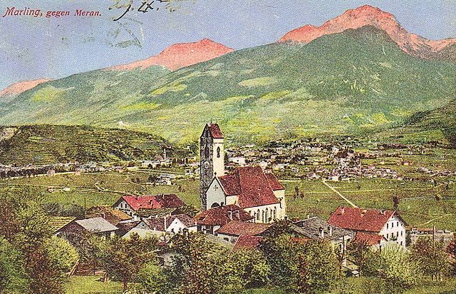

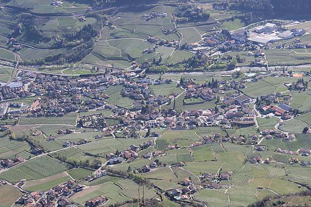
Марленго
- коммуна Италии
Hiking in Марленго
Marling, located in South Tyrol, Italy, is a charming village that offers a plethora of hiking opportunities amidst stunning Alpine scenery. The region is characterized by its mild climate, diverse landscapes, and beautiful panoramic views, making it an ideal destination for both casual walkers and seasoned hikers....
- Страна:
- Почтовый код: 39020
- Телефонный код: 0473
- Код автомобильного номера: BZ
- Координаты: 46° 39' 9" N, 11° 8' 44" E
- GPS треки (wikiloc): [Ссылка]
- Высота над уровнем моря: 363 м m
- Площадь: 12.86 кв.км
- Население: 2710
- Веб сайт: [Ссылка]

Посталь
- коммуна в Италии
Hiking in Посталь
Burgstall is a charming village located in South Tyrol, Italy, known for its picturesque landscapes and proximity to the Alps. Hiking around Burgstall offers a fantastic opportunity to explore the diverse terrain and enjoy stunning views....
- Страна:
- Почтовый код: 39014
- Телефонный код: 0473
- Код автомобильного номера: BZ
- Координаты: 46° 36' 34" N, 11° 11' 35" E
- GPS треки (wikiloc): [Ссылка]
- Высота над уровнем моря: 270 м m
- Площадь: 6.69 кв.км
- Население: 1887
- Веб сайт: [Ссылка]


Сан-Панкрацио
- коммуна в Италии
Hiking in Сан-Панкрацио
St. Pankraz, located in the picturesque region of South Tyrol in Italy, offers a range of hiking opportunities for outdoor enthusiasts of all levels. Here are some key highlights about hiking in St. Pankraz:...
- Страна:
- Почтовый код: 39010
- Телефонный код: 0473
- Код автомобильного номера: BZ
- Координаты: 46° 35' 10" N, 11° 5' 9" E
- GPS треки (wikiloc): [Ссылка]
- Высота над уровнем моря: 735 м m
- Площадь: 63.17 кв.км
- Население: 1549
- Веб сайт: [Ссылка]


Тезимо
- коммуна в Италии
Hiking in Тезимо
Tisens, a charming village located in South Tyrol, Italy, is a fantastic destination for hiking enthusiasts. Nestled in the mountains near Merano, it offers a variety of stunning trails that cater to different skill levels. Here’s what you can expect from hiking in Tisens:...
- Страна:
- Почтовый код: 39010
- Телефонный код: 0473
- Код автомобильного номера: BZ
- Координаты: 46° 33' 56" N, 11° 10' 10" E
- GPS треки (wikiloc): [Ссылка]
- Высота над уровнем моря: 635 м m
- Площадь: 38.13 кв.км
- Население: 1979
- Веб сайт: [Ссылка]