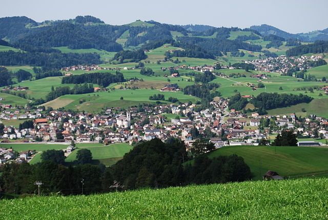
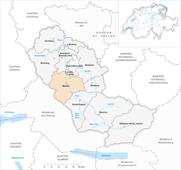
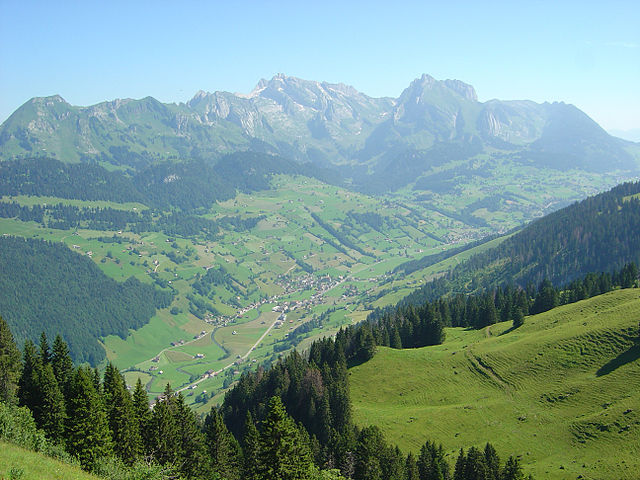
Тоггенбург (Toggenburg Constituency, Wahlkreis Toggenburg)

 Hiking in Тоггенбург
Toggenburg is a beautiful region located in the canton of St. Gallen in Switzerland, renowned for its picturesque landscapes, charming villages, and excellent hiking opportunities. Here are some highlights and tips for hiking in Toggenburg:
1. Scenic Trails
Toggenburg features a variety of hiking trails suited for different skill levels, from beginners to experienced hikers. Some notable trails include:
- Säntis trail: For those looking for a challenge, the trail leading to Säntis, the highest peak in the Alpstein region, offers breathtaking views.
- Kronenstraße: A pleasant walk that connects several villages and provides cultural insights into the local area.
- Toggenburg Panorama Trail: This is a long-distance trail that showcases the stunning panoramas of the Toggenburg valley and the surrounding mountains.
2. Wildlife and Flora
Hikers can enjoy diverse flora and fauna while traversing through lush meadows, forests, and alpine landscapes. Keep an eye out for various bird species and local wildlife, such as chamois and marmots.
3. Accessible Starting Points
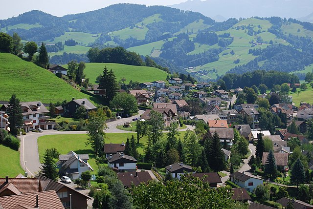
The region is well-connected by public transport, making it easy to access hiking starting points. Many trails start from villages like Wildhaus, Ebnat-Kappel, and Neu St. Johann.
4. Facilities
Toggenburg offers various facilities for hikers, including mountain huts and restaurants where you can enjoy local cuisine. Make sure to try traditional Swiss dishes, such as fondue or rösti, for a truly authentic experience.
5. Seasonal Considerations
- Summer: Perfect for hiking, with well-marked trails and mild weather.
- Autumn: The fall foliage creates a stunning backdrop, and the cooler temperatures make for comfortable hiking.
- Winter: While hiking is possible in lower regions, some trails may be closed due to snow; however, this is a great time for snowshoeing or skiing in the area.
6. Safety Tips
- Always check the weather forecast before heading out.
- Wear proper hiking boots and dress in layers to adapt to changing temperatures.
- Carry enough water and snacks for your hike.
- Stay on marked trails to preserve the natural environment and for your safety.
7. Hiking with Family
Toggenburg also offers family-friendly trails, with interesting stops and educational signs that highlight local history and nature. The region is perfect for a day hike with children.
Conclusion
Hiking in Toggenburg provides a fantastic opportunity to experience the natural beauty of Switzerland while enjoying the tranquility of the mountains. Whether you are a seasoned hiker or just starting out, you will find a trail that suits your needs. Don't forget to take your camera—Toggenburg is incredibly photogenic!
- Страна:

- Столица: Лихтенштейг
- Код автомобильного номера: SG
- Координаты: 47° 17' 40" N, 9° 10' 22" E


- GPS треки (wikiloc): [Ссылка]
- Высота над уровнем моря: 968 м m
- Площадь: 488.75 кв.км
- Википедия русская: wiki(ru)
- Википедия английская: wiki(en)
- Википедия национальная: wiki(de)
- Хранилище Wikidata: Wikidata: Q693185
- Катеория в википедии: [Ссылка]
- код Freebase: [/m/06402x2]
- код GeoNames: Альт: [7285001]
- код BNF: [12308430x]
- идентификатор местоположения ArchINFORM: [42748]
Включает регионы:

Bütschwil-Ganterschwil
Hiking in Bütschwil-Ganterschwil
Bütschwil-Ganterschwil, located in the Canton of St. Gallen in Switzerland, offers a variety of hiking opportunities amidst beautiful natural landscapes. Here are some key points to know about hiking in this area:...
- Страна:
- Телефонный код: 071
- Код автомобильного номера: SG
- Координаты: 47° 21' 0" N, 9° 4' 0" E
- GPS треки (wikiloc): [Ссылка]
- Высота над уровнем моря: 610 м m
- Площадь: 21.80 кв.км
- Население: 4729
- Веб сайт: [Ссылка]


Кирхберг
- община в Швейцарии, Санкт-Галлен
Hiking in Кирхберг
Kirchberg, located in the Canton of St. Gallen, Switzerland, is a beautiful area known for its scenic landscapes and outdoor recreational opportunities. While the region is less known than some of the more touristic spots in Switzerland, it offers several delightful hiking trails that cater to different skill levels....
- Страна:
- Почтовый код: 9533
- Телефонный код: 071
- Код автомобильного номера: SG
- Координаты: 47° 24' 30" N, 9° 1' 34" E
- GPS треки (wikiloc): [Ссылка]
- Высота над уровнем моря: 723 м m
- Площадь: 42.59 кв.км
- Население: 9016
- Веб сайт: [Ссылка]

Хемберг
Hiking in Хемберг
Hemberg, located in the St. Gallen region of Switzerland, is a charming area known for its scenic landscapes and a variety of hiking trails suitable for different skill levels. The region features rolling hills, forests, and panoramic views of the surrounding mountains, making it a great destination for nature enthusiasts and hikers....
- Страна:
- Почтовый код: 9633
- Телефонный код: 071
- Код автомобильного номера: SG
- Координаты: 47° 18' 2" N, 9° 10' 31" E
- GPS треки (wikiloc): [Ссылка]
- Высота над уровнем моря: 786 м m
- Площадь: 20.15 кв.км
- Население: 920
- Веб сайт: [Ссылка]


Моснанг
Hiking in Моснанг
Mosnang is a municipality located in the canton of St. Gallen in Switzerland, known for its beautiful landscapes and outdoor recreational opportunities, including hiking. Here are some key points for those interested in hiking in the Mosnang area:...
- Страна:
- Почтовый код: 9607
- Телефонный код: 071
- Код автомобильного номера: SG
- Координаты: 47° 21' 0" N, 9° 1' 59" E
- GPS треки (wikiloc): [Ссылка]
- Высота над уровнем моря: 735 м m
- Площадь: 50.46 кв.км
- Население: 2884
- Веб сайт: [Ссылка]


Эбнат-Каппель
Hiking in Эбнат-Каппель
Ebnat-Kappel, located in the canton of St. Gallen in Switzerland, is a wonderful destination for hiking enthusiasts. Nestled at the foot of the impressive Alpstein massif, this picturesque Swiss village offers a variety of trails that cater to different skill levels, making it accessible for both casual walkers and more experienced hikers....
- Страна:
- Почтовый код: 9642
- Телефонный код: 071
- Код автомобильного номера: SG
- Координаты: 47° 15' 48" N, 9° 7' 24" E
- GPS треки (wikiloc): [Ссылка]
- Высота над уровнем моря: 630 м m
- Площадь: 43.57 кв.км
- Население: 5012
- Веб сайт: [Ссылка]

Ваттвиль
Hiking in Ваттвиль
Wattwil, located in the Canton of St. Gallen in Switzerland, is a charming town surrounded by stunning landscapes, making it an excellent base for hiking enthusiasts. The region offers a variety of trails that cater to different skill levels, from easy walks to more challenging hikes....
- Страна:
- Почтовый код: 9630
- Телефонный код: 071
- Код автомобильного номера: SG
- Координаты: 47° 17' 58" N, 9° 5' 8" E
- GPS треки (wikiloc): [Ссылка]
- Высота над уровнем моря: 610 м m
- Площадь: 51.25 кв.км
- Население: 8713
- Веб сайт: [Ссылка]


Лютисбург
Hiking in Лютисбург
Lütisburg is a charming area located in the canton of St. Gallen, Switzerland, known for its beautiful landscapes, rolling hills, and scenic trails. Hiking in Lütisburg offers a unique experience with a mix of nature, tranquility, and stunning views of the surrounding countryside and the Alps....
- Страна:
- Почтовый код: 9604
- Телефонный код: 071
- Код автомобильного номера: SG
- Координаты: 47° 23' 41" N, 9° 4' 52" E
- GPS треки (wikiloc): [Ссылка]
- Высота над уровнем моря: 580 м m
- Площадь: 14.09 кв.км
- Население: 1565
- Веб сайт: [Ссылка]

Оберхельфеншвиль
Hiking in Оберхельфеншвиль
Oberhelfenschwil is a charming village located in the canton of St. Gallen, Switzerland. It is an ideal spot for hiking enthusiasts due to its picturesque landscapes, varied terrain, and well-marked trails. Here’s an overview of what you can expect when hiking in and around Oberhelfenschwil:...
- Страна:
- Почтовый код: 9621
- Телефонный код: 071
- Код автомобильного номера: SG
- Координаты: 47° 20' 43" N, 9° 6' 42" E
- GPS треки (wikiloc): [Ссылка]
- Высота над уровнем моря: 792 м m
- Площадь: 12.68 кв.км
- Население: 1267
- Веб сайт: [Ссылка]


Neckertal
Hiking in Neckertal
Neckertal is a picturesque valley located in Switzerland, offering fantastic opportunities for hiking and enjoying nature. Situated in the Canton of St. Gallen, it's surrounded by stunning landscapes, including mountains, forests, and charming villages....
- Страна:
- Почтовый код: 9105, 9115, 9122, 9123, 9125, 9126, 9127
- Код автомобильного номера: SG
- Координаты: 47° 20' 0" N, 9° 8' 0" E
- GPS треки (wikiloc): [Ссылка]
- Высота над уровнем моря: 912 м m
- Площадь: 49.03 кв.км
- Население: 4043
- Веб сайт: [Ссылка]


Лихтенштейг
Hiking in Лихтенштейг
Lichtensteig, a charming municipality in the canton of St. Gallen, Switzerland, offers a variety of hiking opportunities that cater to different skill levels and preferences. The area is characterized by its rolling hills, lush forests, and picturesque landscapes, making it an excellent destination for outdoor enthusiasts....
- Страна:
- Почтовый код: 9620
- Телефонный код: 071
- Код автомобильного номера: SG
- Координаты: 47° 18' 59" N, 9° 4' 59" E
- GPS треки (wikiloc): [Ссылка]
- Высота над уровнем моря: 709 м m
- Площадь: 2.82 кв.км
- Население: 1871
- Веб сайт: [Ссылка]

Wildhaus-Alt St. Johann
Hiking in Wildhaus-Alt St. Johann
Wildhaus-Alt St. Johann is a picturesque hiking destination in the Swiss Alps, particularly known for its stunning landscapes, diverse trails, and access to the Toggenburg region. Here are some key points to consider when planning a hike in this area:...
- Страна:
- Почтовый код: 9656, 9657, 9658
- Код автомобильного номера: SG
- Координаты: 47° 11' 0" N, 9° 17' 0" E
- GPS треки (wikiloc): [Ссылка]
- Высота над уровнем моря: 895 м m
- Площадь: 87.53 кв.км
- Население: 2662
- Веб сайт: [Ссылка]

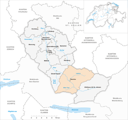
Nesslau
Hiking in Nesslau
Nesslau is a charming municipality located in the Toggenburg region of Switzerland, known for its stunning landscapes and outdoor activities, especially hiking. The area offers a variety of hiking trails that range from easy walks to more challenging hikes, making it suitable for hikers of all skill levels. Here are some highlights of hiking in Nesslau:...
- Страна:
- Почтовый код: 9643, 9650, 9651, 9652, 9655
- Телефонный код: 071
- Код автомобильного номера: SG
- Координаты: 47° 13' 46" N, 9° 13' 6" E
- GPS треки (wikiloc): [Ссылка]
- Высота над уровнем моря: 979 м m
- Площадь: 98.87 кв.км
- Население: 3599
- Веб сайт: [Ссылка]