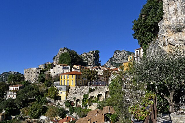
Тудон (Toudon, Toudon)

- коммуна в департаменте Приморские Альпы, регион Прованс — Альпы — Лазурный Берег, Франция
 Hiking in Тудон
Toudon, located in the Alpes-Maritimes department of France, is a beautiful destination for hikers looking to explore the stunning landscapes of the region. Nestled in the foothills of the French Alps, Toudon offers a combination of scenic views, diverse trails, and a peaceful atmosphere.
Hiking Trails
-
Local Trails: There are several hiking trails in and around Toudon that vary in difficulty. Beginner-friendly paths allow for leisurely walks with beautiful views, while more challenging routes provide a good workout and an opportunity to explore the rugged terrain.
-
GR Trails: The GR (Great Hiking) trails, which are an extensive network covering France, often pass through picturesque areas near Toudon. These long-distance paths can offer a more immersive hiking experience if you're looking for a day-long trek.
-
Nature Reserves: The nearby nature reserves and parks often feature well-marked trails. These areas are home to diverse flora and fauna and provide a tranquil hiking experience away from crowded tourist spots.
Best Times to Hike
The best time to hike in Toudon is during the spring and fall when the weather is mild and the natural surroundings are particularly beautiful. Summers can get warm, but the higher elevations can offer cooler temperatures.
Tips for Hiking in Toudon
- Gear: Ensure you wear appropriate hiking boots and carry sufficient water, especially on longer trails. Having layers is advisable since temperatures can vary.
- Navigation: A map or a reliable GPS device can help keep you on track, especially in less-traveled areas.
- Local Wildlife: Be aware of the local wildlife and carry a first-aid kit in case of emergencies.
- Respect Nature: Follow Leave No Trace principles to protect the pristine environment.
Conclusion
Hiking in Toudon can be a rewarding experience, combining beautiful natural scenery with the tranquility of the French countryside. Whether you're looking for a short, leisurely walk or a more challenging hike, Toudon offers a range of options suitable for all skill levels. Make sure to check local resources or visitor centers for updated trail conditions and maps before heading out!
- Страна:

- Почтовый код: 06830
- Координаты: 43° 54' 2" N, 7° 6' 52" E


- GPS треки (wikiloc): [Ссылка]
- Площадь: 18.56 кв.км
- Население: 332
- Википедия русская: wiki(ru)
- Википедия английская: wiki(en)
- Википедия национальная: wiki(fr)
- Хранилище Wikidata: Wikidata: Q592130
- Катеория в википедии: [Ссылка]
- код Freebase: [/m/03m4zqf]
- код Freebase: [/m/03m4zqf]
- код GeoNames: Альт: [6425688]
- код GeoNames: Альт: [6425688]
- номер SIREN: [210601415]
- номер SIREN: [210601415]
- код муниципалитета INSEE: 06141
- код муниципалитета INSEE: 06141
Граничит с регионами:


Малоссен
- коммуна в департаменте Приморские Альпы, регион Прованс — Альпы — Лазурный Берег, Франция
Hiking in Малоссен
Malaussène is a charming area located in the French region of Occitanie, known for its beautiful landscapes and hiking opportunities. While not as famous as some other hiking destinations in France, it offers a variety of trails suitable for all skill levels....
- Страна:
- Почтовый код: 06710
- Координаты: 43° 55' 47" N, 7° 7' 41" E
- GPS треки (wikiloc): [Ссылка]
- Площадь: 19.48 кв.км
- Население: 305
- Веб сайт: [Ссылка]


Турет-дю-Шато
- коммуна в департаменте Приморские Альпы, регион Прованс — Альпы — Лазурный Берег, Франция
Hiking in Турет-дю-Шато
Tourette-du-Château is a charming commune located in the Alpes-Maritimes department in the Provence-Alpes-Côte d'Azur region of southeastern France. This picturesque area offers a variety of hiking opportunities amidst stunning natural scenery, including beautiful landscapes, rolling hills, and rich flora and fauna....
- Страна:
- Почтовый код: 06830
- Координаты: 43° 52' 56" N, 7° 8' 34" E
- GPS треки (wikiloc): [Ссылка]
- Высота над уровнем моря: 900 м m
- Площадь: 9.74 кв.км
- Население: 126

Жилет
- коммуна в департаменте Приморские Альпы, регион Прованс — Альпы — Лазурный Берег, Франция
Hiking in Жилет
Gillette, Wyoming, is surrounded by a variety of outdoor recreational opportunities for hiking enthusiasts. The area is characterized by scenic landscapes, rolling hills, and rugged terrain typical of the high plains region. Here are a few hiking options and considerations while exploring the area:...
- Страна:
- Почтовый код: 06830
- Координаты: 43° 50' 58" N, 7° 9' 49" E
- GPS треки (wikiloc): [Ссылка]
- Площадь: 10.18 кв.км
- Население: 1536

Пьерфё
- коммуна в департаменте Приморские Альпы, регион Прованс — Альпы — Лазурный Берег, Франция
Hiking in Пьерфё
Pierrefeu, located in the Var department of the Provence-Alpes-Côte d'Azur region in France, is a beautiful area known for its picturesque landscapes, including hills, vineyards, and Mediterranean flora. Hiking in and around Pierrefeu offers a variety of trails catering to different levels of experience, making it a great destination for both novice and experienced hikers....
- Страна:
- Почтовый код: 06910
- Координаты: 43° 51' 50" N, 7° 5' 31" E
- GPS треки (wikiloc): [Ссылка]
- Площадь: 22.27 кв.км
- Население: 307


Ле-Фер
- коммуна в департаменте Приморские Альпы, регион Прованс — Альпы — Лазурный Берег, Франция
Hiking in Ле-Фер
Les Ferres is a picturesque village located in the Alpes-Maritimes region of France, near the French Riviera. It sits at an elevation of about 800 meters in the hills above Nice, making it an excellent starting point for various hiking adventures. The area is known for its beautiful landscapes, stunning views, and diverse flora and fauna....
- Страна:
- Почтовый код: 06510
- Координаты: 43° 50' 49" N, 7° 5' 39" E
- GPS треки (wikiloc): [Ссылка]
- Площадь: 13.7 кв.км
- Население: 106