Ле-Фер (Les Ferres, Les Ferres)

- коммуна в департаменте Приморские Альпы, регион Прованс — Альпы — Лазурный Берег, Франция
 Hiking in Ле-Фер
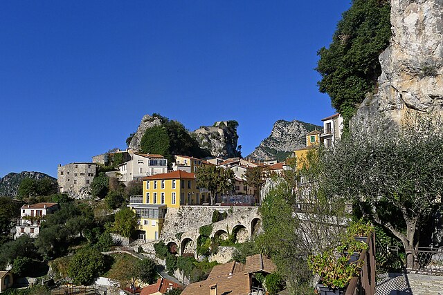
Les Ferres is a picturesque village located in the Alpes-Maritimes region of France, near the French Riviera. It sits at an elevation of about 800 meters in the hills above Nice, making it an excellent starting point for various hiking adventures. The area is known for its beautiful landscapes, stunning views, and diverse flora and fauna.
Hiking Opportunities in Les Ferres:
-
Scenic Trails: The trails around Les Ferres offer a variety of scenic routes that can accommodate hikers of different skill levels. You can find both easy walks for beginners and more challenging hikes for experienced trekkers.
-
Panoramic Views: Many trails provide breathtaking panoramic views of the surrounding mountains and the Mediterranean Sea. This is especially rewarding at sunrise or sunset when the lighting and colors are spectacular.
-
Nature and Wildlife: The region is rich in biodiversity, and hikers may encounter various wildlife species, including birds and small mammals. The diverse ecosystems also present an opportunity to observe various plants and flowers, particularly in spring and early summer.
-
Cultural Exploration: While hiking, you can also explore nearby historical sites and traditional villages. Les Ferres itself boasts charming streets and local architecture that offer insight into the region's rich history and culture.
-
Local Guides: If you're not familiar with the area, consider hiring a local guide. They can provide you with valuable knowledge about the trails, as well as safety tips and insights about the local environment.
Preparing for Your Hike:
- Gear: Make sure to wear appropriate hiking footwear and clothing. Depending on the season, layers may be necessary. Don't forget sunscreen, a hat, and plenty of water.
- Maps and Navigation: It’s advisable to carry a map of the trails or a GPS device, as some paths may not be well-marked.
- Weather Awareness: Check the weather forecast before heading out, as conditions can change quickly in mountainous areas.
- Safety: Always let someone know your hiking plans and estimated return time. If hiking alone, it’s best to stay on marked trails.
Recommended Hikes:
- Les Ferres to Col de la Vence: This moderate trail offers stunning views and a great workout with varied terrain.
- Le Mont Macaron: A more challenging hike that rewards adventurers with incredible vistas and a sense of accomplishment.
Overall, hiking in and around Les Ferres can be a wonderful experience that showcases the natural beauty of the French countryside while providing a healthy and invigorating outdoor activity.
- Страна:

- Почтовый код: 06510
- Координаты: 43° 50' 49" N, 7° 5' 39" E


- GPS треки (wikiloc): [Ссылка]
- Площадь: 13.7 кв.км
- Население: 106
- Википедия русская: wiki(ru)
- Википедия английская: wiki(en)
- Википедия национальная: wiki(fr)
- Хранилище Wikidata: Wikidata: Q977945
- Катеория в википедии: [Ссылка]
- код Freebase: [/m/03m4_m_]
- код Freebase: [/m/03m4_m_]
- код GeoNames: Альт: [6456677]
- код GeoNames: Альт: [6456677]
- номер SIREN: [210600615]
- номер SIREN: [210600615]
- код муниципалитета INSEE: 06061
- код муниципалитета INSEE: 06061
Граничит с регионами:

Жилет
- коммуна в департаменте Приморские Альпы, регион Прованс — Альпы — Лазурный Берег, Франция
Hiking in Жилет
Gillette, Wyoming, is surrounded by a variety of outdoor recreational opportunities for hiking enthusiasts. The area is characterized by scenic landscapes, rolling hills, and rugged terrain typical of the high plains region. Here are a few hiking options and considerations while exploring the area:...
- Страна:
- Почтовый код: 06830
- Координаты: 43° 50' 58" N, 7° 9' 49" E
- GPS треки (wikiloc): [Ссылка]
- Площадь: 10.18 кв.км
- Население: 1536

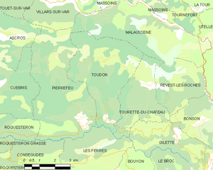
Тудон
- коммуна в департаменте Приморские Альпы, регион Прованс — Альпы — Лазурный Берег, Франция
Hiking in Тудон
Toudon, located in the Alpes-Maritimes department of France, is a beautiful destination for hikers looking to explore the stunning landscapes of the region. Nestled in the foothills of the French Alps, Toudon offers a combination of scenic views, diverse trails, and a peaceful atmosphere....
- Страна:
- Почтовый код: 06830
- Координаты: 43° 54' 2" N, 7° 6' 52" E
- GPS треки (wikiloc): [Ссылка]
- Площадь: 18.56 кв.км
- Население: 332

Пьерфё
- коммуна в департаменте Приморские Альпы, регион Прованс — Альпы — Лазурный Берег, Франция
Hiking in Пьерфё
Pierrefeu, located in the Var department of the Provence-Alpes-Côte d'Azur region in France, is a beautiful area known for its picturesque landscapes, including hills, vineyards, and Mediterranean flora. Hiking in and around Pierrefeu offers a variety of trails catering to different levels of experience, making it a great destination for both novice and experienced hikers....
- Страна:
- Почтовый код: 06910
- Координаты: 43° 51' 50" N, 7° 5' 31" E
- GPS треки (wikiloc): [Ссылка]
- Площадь: 22.27 кв.км
- Население: 307


Буйон
- коммуна в департаменте Приморские Альпы, регион Прованс — Альпы — Лазурный Берег, Франция
Hiking in Буйон
Bouyon is a small village located in the Alpes-Maritimes region of southeastern France, nestled in the hills near Nice. The area offers stunning natural scenery and a variety of hiking opportunities, making it a great destination for outdoor enthusiasts. Here’s what you can expect while hiking in and around Bouyon:...
- Страна:
- Почтовый код: 06510
- Координаты: 43° 49' 28" N, 7° 7' 23" E
- GPS треки (wikiloc): [Ссылка]
- Площадь: 12.29 кв.км
- Население: 494


Безодён-лез-Альп
- коммуна в департаменте Приморские Альпы, регион Прованс — Альпы — Лазурный Берег, Франция
Hiking in Безодён-лез-Альп
Bézaudun-les-Alpes is a charming commune located in the Alpes-Maritimes department in southeastern France. The area is known for its stunning natural landscapes, historical architecture, and a variety of hiking opportunities that cater to different experience levels. Here are some highlights and tips for hiking in and around Bézaudun-les-Alpes:...
- Страна:
- Почтовый код: 06510
- Координаты: 43° 48' 27" N, 7° 5' 46" E
- GPS треки (wikiloc): [Ссылка]
- Площадь: 21.44 кв.км
- Население: 243
- Веб сайт: [Ссылка]

Консегюд
- коммуна в департаменте Приморские Альпы, регион Прованс — Альпы — Лазурный Берег, Франция
Hiking in Консегюд
It looks like there may be a typo in your query, as "Conségudes" does not appear to be a recognized hiking destination or area. However, if you're referring to a specific location in the mountains or a national park, please provide more context or check the spelling....
- Страна:
- Почтовый код: 06510
- Координаты: 43° 50' 36" N, 7° 2' 55" E
- GPS треки (wikiloc): [Ссылка]
- Площадь: 12.47 кв.км
- Население: 106