
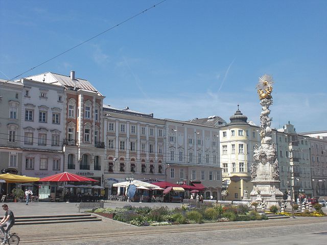
Траун (Traun, Traun)
 Hiking in Траун
Traun is a beautiful area located in Austria, particularly known for its stunning natural landscapes, including mountains, lakes, and rivers. The region is popular among hikers due to its diverse trails that cater to various skill levels, from beginners to experienced hikers. Here are some key points about hiking in the Traun area:
Trail Options:
-
Traunstein Mountain: One of the most popular hikes is the ascent of Traunstein. The mountain offers several routes, each providing breathtaking views of the surrounding area, including Lake Traunsee. The most common route is a well-marked trail that includes some steep sections and requires a bit of scrambling.
-
Lake Traunsee: The area around Lake Traunsee offers a variety of scenic hiking trails that can vary in length and difficulty. The trails often combine lakeside views with stunning mountainous backdrops.
-
Kalmberg: Another great hike is to Kalmberg, which provides panoramic views and an opportunity to experience the region's flora and fauna.
Hiking Conditions:
- Season: The best time for hiking in Traun is typically from late spring to early autumn, when the weather is generally more stable and the trails are clear of snow.
- Weather: Always check the weather conditions before heading out, as they can change rapidly in the mountainous areas.
Preparation:
- Gear: It's crucial to wear appropriate gear, including sturdy hiking boots, weather-appropriate clothing, and a good backpack. Carry sufficient water and snacks.
- Navigation: While many trails are well-marked, bringing a map or a GPS device can be helpful, especially for less traveled paths.
- Safety: Inform someone about your hiking plans and estimated return time. Be aware of your limits and do not hesitate to turn back if conditions become unsafe.
Nearby Attractions:
After a day of hiking, consider exploring the local culture, including traditional Austrian cuisine at nearby restaurants, or visiting attractions such as Gmunden with its charming architecture and the impressive Schloss Ort.
Conclusion:
Hiking in the Traun area offers a wonderful escape into nature with opportunities for adventure and tranquility. Whether you're looking for a challenging climb or a leisurely lakeside stroll, this region promises a delightful experience for outdoor enthusiasts.
- Страна:

- Почтовый код: 4050
- Телефонный код: 07229
- Код автомобильного номера: LL
- Координаты: 48° 13' 18" N, 14° 14' 23" E


- GPS треки (wikiloc): [Ссылка]
- Высота над уровнем моря: 273 м m
- Площадь: 15.49 кв.км
- Население: 24477
- Веб сайт: http://www.traun.at/
- Википедия русская: wiki(ru)
- Википедия английская: wiki(en)
- Википедия национальная: wiki(de)
- Хранилище Wikidata: Wikidata: Q260176
- Катеория в википедии: [Ссылка]
- код Freebase: [/m/05_w95]
- код GeoNames: Альт: [7872061]
- код VIAF: Альт: [233735285]
- код GND: Альт: [4122736-0]
- идентификатор местоположения ArchINFORM: [10559]
- код LCNAF: Альт: [nr95015274]
- место в MusicBrainz: [56eb4c37-29e0-42ec-9e8f-d0295fcc3ca1]
- код в энциклопедии «Британника онлайн»: [place/Traun]
- код места в Facebook: [114082948605632]
- код австрийского муниципалитета: [41021]
Граничит с регионами:

Ансфельден
Hiking in Ансфельден
Ansfelden, located in Austria near Linz, offers a variety of hiking trails suitable for different skill levels. The region features picturesque landscapes, including lush forests, rolling hills, and scenic views of the surrounding areas, making it an excellent destination for nature enthusiasts....
- Страна:
- Код автомобильного номера: LL
- Координаты: 48° 12' 30" N, 14° 17' 20" E
- GPS треки (wikiloc): [Ссылка]
- Высота над уровнем моря: 289 м m
- Площадь: 31.33 кв.км
- Население: 16194
- Веб сайт: [Ссылка]

Линц
- административный центр федеральной земли Верхняя Австрия
Hiking in Линц
Linz, the third-largest city in Austria, offers a variety of beautiful hiking opportunities in and around the area. Here are some highlights for hiking in and around Linz:...
- Страна:
- Почтовый код: 4030–4039; 4020–4029; 4040–4049; 4010
- Телефонный код: 0732
- Код автомобильного номера: L
- Координаты: 48° 18' 0" N, 14° 17' 0" E
- GPS треки (wikiloc): [Ссылка]
- Высота над уровнем моря: 261 м m
- Площадь: 95.99 кв.км
- Население: 204846
- Веб сайт: [Ссылка]

Леондинг
Hiking in Леондинг
Leonding, located in Upper Austria near the city of Linz, is a charming area with several hiking opportunities that can be enjoyed by both beginners and experienced hikers. The region features lush landscapes, rolling hills, and beautiful forests, making it a delightful destination for outdoor enthusiasts....
- Страна:
- Телефонный код: 0732
- Код автомобильного номера: LL
- Координаты: 48° 16' 45" N, 14° 15' 10" E
- GPS треки (wikiloc): [Ссылка]
- Высота над уровнем моря: 287 м m
- Площадь: 24.05 кв.км
- Население: 28698
- Веб сайт: [Ссылка]
Пашинг
Hiking in Пашинг
Pasching is a small town located near Linz in Upper Austria, known for its scenic landscapes and proximity to the Danube River. While Pasching itself may not be a major hiking destination, it offers access to several hiking routes in the surrounding areas....
- Страна:
- Почтовый код: 4061
- Код автомобильного номера: LL
- Координаты: 48° 15' 32" N, 14° 12' 10" E
- GPS треки (wikiloc): [Ссылка]
- Высота над уровнем моря: 295 м m
- Площадь: 12.48 кв.км
- Население: 7552
- Веб сайт: [Ссылка]

Хёршинг
Hiking in Хёршинг
Hörsching, located in Upper Austria near Linz, offers various opportunities for hiking enthusiasts. While Hörsching itself may not have extensive hiking trails within its immediate vicinity, its location provides easy access to beautiful surrounding areas....
- Страна:
- Почтовый код: 4063
- Телефонный код: 07221
- Код автомобильного номера: LL
- Координаты: 48° 13' 36" N, 14° 10' 46" E
- GPS треки (wikiloc): [Ссылка]
- Высота над уровнем моря: 294 м m
- Площадь: 20 кв.км
- Население: 6062
- Веб сайт: [Ссылка]


Пуккинг
Hiking in Пуккинг
Pucking is a small municipality in Austria, located in the upper Austrian region of Pucking. While it may not be universally recognized as a hiking hotspot, it is surrounded by beautiful landscapes that can provide opportunities for outdoor enthusiasts....
- Страна:
- Почтовый код: 4055
- Телефонный код: 07229
- Код автомобильного номера: LL
- Координаты: 48° 11' 21" N, 14° 11' 1" E
- GPS треки (wikiloc): [Ссылка]
- Высота над уровнем моря: 286 м m
- Площадь: 19.81 кв.км
- Население: 3904
- Веб сайт: [Ссылка]