Валлебона (Vallebona, Vallebona)
.svg)
- коммуна Италии
 Hiking in Валлебона
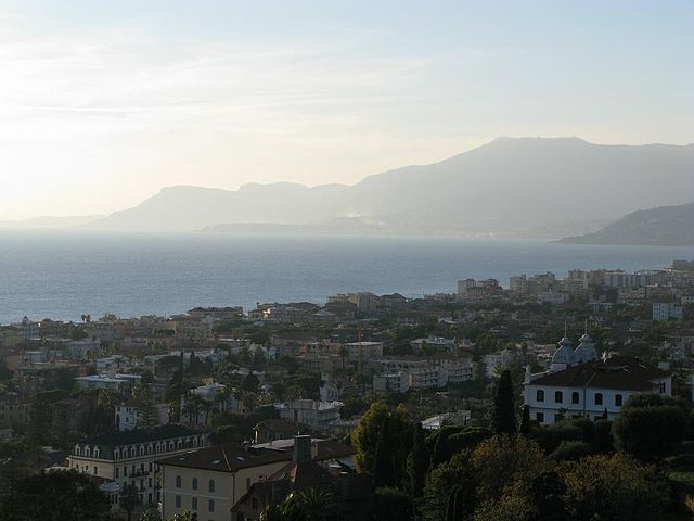
Vallebona is a picturesque village located in the Italian region of Liguria, near the French border. Nestled in the hills above the coastline, it offers stunning views of the surrounding countryside and the Ligurian Sea. Hiking in the area around Vallebona can be a rewarding experience, as it encompasses a mix of natural beauty, cultural heritage, and diverse trails.
Hiking Trails and Highlights:
-
The Old Village Paths: Explore the ancient paths that connect Vallebona with nearby villages such as Bordighera and Ospedaletti. These trails often wind through olive groves and vineyards, providing a glimpse into the traditional Ligurian way of life.
-
The Mediterranean Trail: This long-distance trail runs along the coast, providing access to beautiful coastal views and secluded beaches. Portions of the trail can be accessed from Vallebona, allowing for both short hikes and longer adventures.
-
Monte Nero: A hike to Monte Nero offers a chance to enjoy panoramic views from its summit. The trail here varies in difficulty, making it suitable for both novice and experienced hikers.
-
Flora and Fauna: The area around Vallebona is home to a rich array of plant and animal life. Hikers can expect to see Mediterranean vegetation, wildflowers, and perhaps even some wildlife, like deer or various bird species.
-
Cultural Stops: While hiking, take time to visit local sites, such as ancient churches or historic ruins, which add to the charm of the hiking experience.
Tips for Hiking in Vallebona:
-
Gear: Ensure you wear appropriate hiking gear, including sturdy footwear and weather-appropriate clothing. Trails can vary in terrain and may include steep sections.
-
Hydration and Snacks: Pack enough water and some snacks to keep your energy up during your hikes.
-
Map and Guidance: Familiarize yourself with local maps and possibly download GPS apps that can help navigate the trails. Some routes may not be well-marked.
-
Respect the Environment: As in any hiking area, it's important to follow Leave No Trace principles. This helps preserve the beauty of the landscape for future visitors.
-
Local Advice: Consider consulting with local guides or the tourist information center in Bordighera for the latest trail conditions and recommendations.
Best Time to Visit:
The best times for hiking in Vallebona are spring (April to June) and fall (September to October) when the weather is mild, and the landscapes are lush and vibrant. Summer can be hot, while winter might present challenges due to cooler temperatures.
Hiking in Vallebona allows you to experience the natural beauty and cultural richness of the Ligurian region. Whether you are looking for a leisurely stroll or a challenging trek, you will find a variety of options to suit your preferences.
- Страна:

- Почтовый код: 18012
- Телефонный код: 0184
- Код автомобильного номера: IM
- Координаты: 43° 48' 44" N, 7° 39' 55" E


- GPS треки (wikiloc): [Ссылка]
- Высота над уровнем моря: 149 м m
- Площадь: 5.88 кв.км
- Население: 1319
- Веб сайт: http://www.vallebona.info
- Википедия русская: wiki(ru)
- Википедия английская: wiki(en)
- Википедия национальная: wiki(it)
- Хранилище Wikidata: Wikidata: Q269885
- Катеория в википедии: [Ссылка]
- код Freebase: [/m/0gbz7t]
- код GeoNames: Альт: [6539670]
- ID отношения в OpenStreetMap: [42648]
- код ISTAT: 008062
- кадастровый код Италии: L596
Граничит с регионами:


Сан-Бьяджо-делла-Чима
- коммуна Италии
Hiking in Сан-Бьяджо-делла-Чима
San Biagio della Cima is a charming village located in the region of Liguria, Italy, and is part of the municipality of Ventimiglia. Nestled in the hills above the coastal region, it offers a variety of hiking opportunities that showcase the stunning natural beauty of the area....
- Страна:
- Почтовый код: 18036
- Телефонный код: 0184
- Код автомобильного номера: IM
- Координаты: 43° 49' 7" N, 7° 38' 59" E
- GPS треки (wikiloc): [Ссылка]
- Высота над уровнем моря: 100 м m
- Площадь: 4.31 кв.км
- Население: 1305
- Веб сайт: [Ссылка]

Бордигера
- коммуна Италии
Hiking in Бордигера
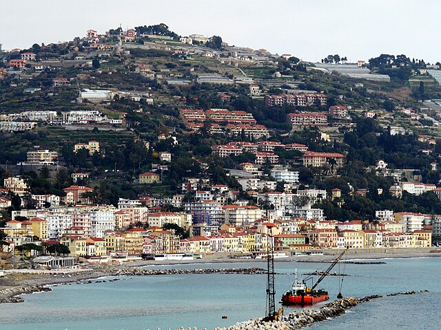
Bordighera, located on the Italian Riviera in the Liguria region, offers a variety of scenic hiking opportunities that can cater to different skill levels. Here are some highlights and tips for hiking in and around Bordighera:...
- Страна:
- Почтовый код: 18012
- Телефонный код: 0184
- Код автомобильного номера: IM
- Координаты: 43° 46' 44" N, 7° 40' 20" E
- GPS треки (wikiloc): [Ссылка]
- Высота над уровнем моря: 5 м m
- Площадь: 10.65 кв.км
- Население: 10412
- Веб сайт: [Ссылка]

Оспедалетти
- коммуна Италии
Hiking in Оспедалетти
Ospedaletti, located along the Italian Riviera near the French border in the region of Liguria, offers beautiful coastal landscapes, charming towns, and access to a variety of hiking trails. Here are some highlights about hiking in and around Ospedaletti:...
- Страна:
- Почтовый код: 18014
- Телефонный код: 0184
- Код автомобильного номера: IM
- Координаты: 43° 48' 2" N, 7° 43' 4" E
- GPS треки (wikiloc): [Ссылка]
- Высота над уровнем моря: 5 м m
- Площадь: 5.45 кв.км
- Население: 3292
- Веб сайт: [Ссылка]


Перинальдо
- коммуна Италии
Hiking in Перинальдо
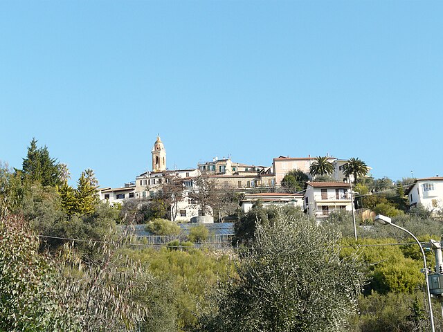
Perinaldo is a charming village located in the Italian region of Liguria, known for its stunning natural landscapes and historic architecture. It's situated in the hills above the Riviera dei Fiori, offering excellent opportunities for hiking and outdoor activities. Here are some key points about hiking in Perinaldo:...
- Страна:
- Почтовый код: 18032
- Телефонный код: 0184
- Код автомобильного номера: IM
- Координаты: 43° 52' 1" N, 7° 40' 28" E
- GPS треки (wikiloc): [Ссылка]
- Высота над уровнем моря: 572 м m
- Площадь: 20.3 кв.км
- Население: 871
- Веб сайт: [Ссылка]

Себорга
- коммуна Италии
Hiking in Себорга
Seborga is a charming village located in the Italian Riviera, within the province of Imperia in the Liguria region. Known for its picturesque views, historic architecture, and a rich cultural history, Seborga also offers a variety of hiking opportunities for outdoor enthusiasts. Here’s what you need to know about hiking in and around Seborga:...
- Страна:
- Почтовый код: 18012
- Телефонный код: 0184
- Код автомобильного номера: IM
- Координаты: 43° 49' 34" N, 7° 41' 38" E
- GPS треки (wikiloc): [Ссылка]
- Высота над уровнем моря: 500 м m
- Площадь: 4.87 кв.км
- Население: 297
- Веб сайт: [Ссылка]


Сольдано
- коммуна Италии
Hiking in Сольдано
Soldano is a charming village located in the Liguria region of Italy, nestled in the hills of the Nervia Valley, not far from the Mediterranean coast. The area is ideal for hiking enthusiasts, offering a mix of coastal paths, hill trails, and scenic views. Here are some highlights and tips for hiking in Soldano:...
- Страна:
- Почтовый код: 18036
- Телефонный код: 0184
- Код автомобильного номера: IM
- Координаты: 43° 49' 42" N, 7° 39' 20" E
- GPS треки (wikiloc): [Ссылка]
- Высота над уровнем моря: 80 м m
- Площадь: 3.47 кв.км
- Население: 1029
- Веб сайт: [Ссылка]


Валлекрозия
- коммуна Италии
Hiking in Валлекрозия
Vallecrosia, located on the Italian Riviera in the Liguria region, is a charming town that offers a variety of hiking options, primarily around the scenic coastal areas and the nearby mountains. Here are some key points about hiking in and around Vallecrosia:...
- Страна:
- Почтовый код: 18019
- Телефонный код: 0184
- Код автомобильного номера: IM
- Координаты: 43° 47' 35" N, 7° 38' 38" E
- GPS треки (wikiloc): [Ссылка]
- Высота над уровнем моря: 5 м m
- Площадь: 3.68 кв.км
- Население: 6972
- Веб сайт: [Ссылка]