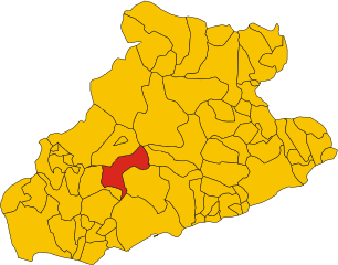
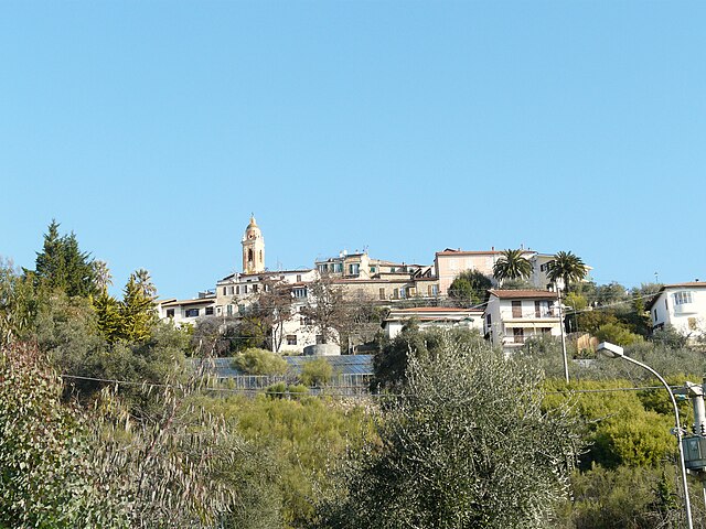
Перинальдо (Perinaldo, Perinaldo)
.svg)
- коммуна Италии
 Hiking in Перинальдо
Perinaldo is a charming village located in the Italian region of Liguria, known for its stunning natural landscapes and historic architecture. It's situated in the hills above the Riviera dei Fiori, offering excellent opportunities for hiking and outdoor activities. Here are some key points about hiking in Perinaldo:
Scenic Trails
- Natural Beauty: The area around Perinaldo features diverse landscapes, from lush Mediterranean forests to panoramic views of the coastline and surrounding mountains.
- Variety of Difficulty Levels: Trails vary in difficulty, catering to both beginners and experienced hikers. Whether you are looking for a leisurely stroll or a challenging hike, there’s something for everyone.
Main Hiking Routes
- Monte Faudo: A popular hike that provides breathtaking views of the coastline and valleys. The trail is well-marked and can be a rewarding ascent for those looking for a bit of a workout.
- Bussana & Sanremo Loop: This trail connects Perinaldo to nearby villages like Bussana and Sanremo, allowing hikers to experience the local culture and enjoy beautiful views along the way.
Additional Tips
- Best Time to Hike: Spring and autumn are the ideal seasons for hiking in Perinaldo. The weather is usually mild, and the landscapes are particularly beautiful during these times.
- What to Bring: Always carry plenty of water, snacks, a map or GPS device, and wear appropriate footwear. Sun protection is also crucial in the warmer months.
- Local Insights: Engaging with local hiking groups or guides can enhance your experience, as they can share insights about the history and flora/flora in the area.
Additional Activities
After a hike, consider exploring the village of Perinaldo itself, visiting its historic sites, or enjoying some local cuisine in a cafe or restaurant.
Hiking in and around Perinaldo provides a wonderful opportunity to immerse yourself in the natural beauty of Liguria, along with its rich history and culture. Enjoy your outdoor adventures!
- Страна:

- Почтовый код: 18032
- Телефонный код: 0184
- Код автомобильного номера: IM
- Координаты: 43° 52' 1" N, 7° 40' 28" E


- GPS треки (wikiloc): [Ссылка]
- Высота над уровнем моря: 572 м m
- Площадь: 20.3 кв.км
- Население: 871
- Веб сайт: http://www.comune.perinaldo.im.it/
- Википедия русская: wiki(ru)
- Википедия английская: wiki(en)
- Википедия национальная: wiki(it)
- Хранилище Wikidata: Wikidata: Q269476
- Катеория в википедии: [Ссылка]
- код Freebase: [/m/0gbyx3]
- код GeoNames: Альт: [6536076]
- ID отношения в OpenStreetMap: [42676]
- код ISTAT: 008040
- кадастровый код Италии: G454
Граничит с регионами:


Сан-Бьяджо-делла-Чима
- коммуна Италии
Hiking in Сан-Бьяджо-делла-Чима
San Biagio della Cima is a charming village located in the region of Liguria, Italy, and is part of the municipality of Ventimiglia. Nestled in the hills above the coastal region, it offers a variety of hiking opportunities that showcase the stunning natural beauty of the area....
- Страна:
- Почтовый код: 18036
- Телефонный код: 0184
- Код автомобильного номера: IM
- Координаты: 43° 49' 7" N, 7° 38' 59" E
- GPS треки (wikiloc): [Ссылка]
- Высота над уровнем моря: 100 м m
- Площадь: 4.31 кв.км
- Население: 1305
- Веб сайт: [Ссылка]


Априкале
- коммуна Италии
Hiking in Априкале
Apricale, a picturesque village in the Liguria region of Italy, offers some fantastic hiking opportunities. Nestled in the Sanremo valleys and surrounded by lush vegetation, it boasts beautiful landscapes, historical sites, and a rich cultural experience....
- Страна:
- Почтовый код: 18035
- Телефонный код: 0184
- Код автомобильного номера: IM
- Координаты: 43° 52' 50" N, 7° 39' 38" E
- GPS треки (wikiloc): [Ссылка]
- Высота над уровнем моря: 291 м m
- Площадь: 19.94 кв.км
- Население: 618
- Веб сайт: [Ссылка]

Баярдо
- коммуна Италии
Hiking in Баярдо
Bajardo, a charming village located in the Liguria region of Italy, offers some beautiful hiking opportunities, particularly for those who appreciate nature and stunning landscapes. Nestled in the hills of the Italian Riviera, it's surrounded by lush greenery, picturesque vistas, and a rich cultural heritage....
- Страна:
- Почтовый код: 18031
- Телефонный код: 0184
- Код автомобильного номера: IM
- Координаты: 43° 54' 13" N, 7° 43' 6" E
- GPS треки (wikiloc): [Ссылка]
- Высота над уровнем моря: 900 м m
- Площадь: 24.32 кв.км
- Население: 326
- Веб сайт: [Ссылка]


Дольчеаккуа
- коммуна Италии
Hiking in Дольчеаккуа
Dolceacqua is a charming village located in the Italian region of Liguria, near the border with France. It’s known for its picturesque medieval architecture, stunning landscapes, and the beautiful surrounding hills and valleys that offer a variety of hiking opportunities....
- Страна:
- Почтовый код: 18035
- Телефонный код: 0184
- Код автомобильного номера: IM
- Координаты: 43° 50' 53" N, 7° 37' 26" E
- GPS треки (wikiloc): [Ссылка]
- Высота над уровнем моря: 51 м m
- Площадь: 20.28 кв.км
- Население: 2093
- Веб сайт: [Ссылка]

Себорга
- коммуна Италии
Hiking in Себорга
Seborga is a charming village located in the Italian Riviera, within the province of Imperia in the Liguria region. Known for its picturesque views, historic architecture, and a rich cultural history, Seborga also offers a variety of hiking opportunities for outdoor enthusiasts. Here’s what you need to know about hiking in and around Seborga:...
- Страна:
- Почтовый код: 18012
- Телефонный код: 0184
- Код автомобильного номера: IM
- Координаты: 43° 49' 34" N, 7° 41' 38" E
- GPS треки (wikiloc): [Ссылка]
- Высота над уровнем моря: 500 м m
- Площадь: 4.87 кв.км
- Население: 297
- Веб сайт: [Ссылка]


Сольдано
- коммуна Италии
Hiking in Сольдано
Soldano is a charming village located in the Liguria region of Italy, nestled in the hills of the Nervia Valley, not far from the Mediterranean coast. The area is ideal for hiking enthusiasts, offering a mix of coastal paths, hill trails, and scenic views. Here are some highlights and tips for hiking in Soldano:...
- Страна:
- Почтовый код: 18036
- Телефонный код: 0184
- Код автомобильного номера: IM
- Координаты: 43° 49' 42" N, 7° 39' 20" E
- GPS треки (wikiloc): [Ссылка]
- Высота над уровнем моря: 80 м m
- Площадь: 3.47 кв.км
- Население: 1029
- Веб сайт: [Ссылка]


Валлебона
- коммуна Италии
Hiking in Валлебона
Vallebona is a picturesque village located in the Italian region of Liguria, near the French border. Nestled in the hills above the coastline, it offers stunning views of the surrounding countryside and the Ligurian Sea. Hiking in the area around Vallebona can be a rewarding experience, as it encompasses a mix of natural beauty, cultural heritage, and diverse trails....
- Страна:
- Почтовый код: 18012
- Телефонный код: 0184
- Код автомобильного номера: IM
- Координаты: 43° 48' 44" N, 7° 39' 55" E
- GPS треки (wikiloc): [Ссылка]
- Высота над уровнем моря: 149 м m
- Площадь: 5.88 кв.км
- Население: 1319
- Веб сайт: [Ссылка]


Сан-Ремо
- коммуна Италии
Hiking in Сан-Ремо
Sanremo, located on the Italian Riviera in the region of Liguria, is well-known for its beautiful landscapes, mild climate, and stunning coastal views. Hiking in and around Sanremo offers a wonderful opportunity to explore the natural beauty of the area, from the Mediterranean coast to the surrounding hills and mountains. Here are some highlights and tips for hiking in Sanremo:...
- Страна:
- Почтовый код: 18038
- Телефонный код: 0184
- Код автомобильного номера: IM
- Координаты: 43° 49' 17" N, 7° 47' 12" E
- GPS треки (wikiloc): [Ссылка]
- Высота над уровнем моря: 15 м m
- Площадь: 55.96 кв.км
- Население: 54824
- Веб сайт: [Ссылка]