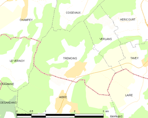
Верлан (Верхняя Сона) (Verlans, Verlans)

- коммуна во Франции
 Hiking in Верлан (Верхняя Сона)
Hiking in Verlaine, or the surrounding regions depending on the specific area you are referencing, can be a wonderful outdoor activity. However, it's important to note that Verlaine itself, in Belgium, is a small village, and may not have extensive hiking trails.
If you’re looking for hiking recommendations in general for the region, here are some tips:
-
Local Trails: Investigate local trails in nearby nature reserves or parks. Areas such as the Ardennes region, which is a bit further away from Verlaine, are known for their beautiful landscapes, forests, and varied terrain suitable for hiking.
-
Difficulty Levels: Consider your fitness level and choose trails that match. There are typically paths ranging from easy, family-friendly hikes to more challenging routes requiring proper hiking gear and experience.
-
Seasonal Considerations: The best time for hiking in Belgium is typically spring and autumn, when the weather is mild and the scenery is beautiful. However, be mindful of winter conditions if hiking during that time, as some paths may be icy or snow-covered.
-
Guided Hikes: If you are unfamiliar with the area, you might consider joining a guided hiking tour, which can provide insights into the local flora, fauna, and geography.
-
Local Resources: Check out local hiking clubs or online platforms for maps and trail recommendations. Websites dedicated to hiking often provide user reviews and updates on trail conditions.
-
Safety: Always prioritize safety by wearing appropriate shoes, carrying enough water, and informing someone about your route, especially if you are hiking alone.
If you have a particular trail or area in mind near Verlaine that you want to explore, let me know, and I can offer more specific details!
- Страна:

- Почтовый код: 70400
- Координаты: 47° 34' 18" N, 6° 43' 15" E


- GPS треки (wikiloc): [Ссылка]
- Площадь: 1.64 кв.км
- Население: 193
- Веб сайт: http://www.mairie-verlans.ht.cx/
- Википедия русская: wiki(ru)
- Википедия английская: wiki(en)
- Википедия национальная: wiki(fr)
- Хранилище Wikidata: Wikidata: Q511514
- Катеория в википедии: [Ссылка]
- код Freebase: [/m/03nv_yk]
- код GeoNames: Альт: [6442156]
- номер SIREN: [217005479]
- код BNF: [15272939n]
- код муниципалитета INSEE: 70547
Граничит с регионами:

Тремуэн
- коммуна во Франции
Hiking in Тремуэн
Trémoins is a small village located in the Bourgogne-Franche-Comté region of France. While it might not be as widely known as other hiking destinations, the surrounding countryside offers opportunities for outdoor activities including hiking....
- Страна:
- Почтовый код: 70400
- Координаты: 47° 33' 42" N, 6° 42' 17" E
- GPS треки (wikiloc): [Ссылка]
- Площадь: 4.03 кв.км
- Население: 377
- Веб сайт: [Ссылка]


Laire
- коммуна во Франции
Hiking in Laire
Laire is not widely recognized as a specific hiking destination, so it's possible that you meant a different location—or that Laire may be a less-known area with trails. If you are referring to a region or national park, like in the French Alps, Pyrenees, or anywhere else specifically, please clarify, and I will be happy to provide information on that area....
- Страна:
- Почтовый код: 25550
- Координаты: 47° 33' 2" N, 6° 43' 58" E
- GPS треки (wikiloc): [Ссылка]
- Площадь: 3.17 кв.км
- Население: 395


Куазво
- коммуна во Франции
Hiking in Куазво
Coisevaux, located in the scenic Jura region of France, offers an excellent environment for hiking enthusiasts. The Jura mountains are known for their diverse landscapes, which include lush forests, rolling hills, and stunning viewpoints overlooking valleys....
- Страна:
- Почтовый код: 70400
- Координаты: 47° 34' 47" N, 6° 42' 22" E
- GPS треки (wikiloc): [Ссылка]
- Площадь: 4.18 кв.км
- Население: 341


Таве
- коммуна во Франции
Hiking in Таве
Tavey, located in the picturesque region of Switzerland, offers a variety of hiking opportunities that cater to different skill levels and preferences. The surrounding landscapes are characterized by stunning alpine scenery, beautiful meadows, and charming villages....
- Страна:
- Почтовый код: 70400
- Координаты: 47° 33' 58" N, 6° 44' 33" E
- GPS треки (wikiloc): [Ссылка]
- Площадь: 2.96 кв.км
- Население: 510