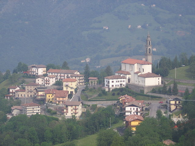
Вертова (Vertova, Vertova)
.svg)
- коммуна Италии
 Hiking in Вертова
Vertova is a charming town located in the Bergamo province of Lombardy, Italy, surrounded by picturesque mountains and beautiful landscapes, making it an appealing spot for hikers. The area is characterized by its rich natural beauty, featuring forests, rivers, and stunning views of the surrounding Alps.
Hiking Options in Vertova:
-
Sentiero del Cielo:
- This is one of the popular trails in the area, known for its breathtaking panorama. The trail takes you through lush forests and offers views of the Seriana Valley.
-
Val Vertova Trail:
- This route follows the creek that flows through the valley, showcasing beautiful rock formations and natural features. It’s an easy to moderate hike, suitable for families and less experienced hikers.
-
Monte Grem:
- For those seeking a more challenging hike, ascending Monte Grem provides stunning views of the surrounding mountain ranges. The hike can be strenuous in parts, so a good level of fitness is recommended.
-
Ciaspolada:
- During the winter months, the area is great for snowshoeing (ciaspole), offering a unique and serene experience among the snow-covered landscapes.
Tips for Hiking in Vertova:
- Map and GPS: Always carry a detailed map or GPS device, as some trails can be less marked.
- Weather: Check the weather forecast before heading out, as conditions can change rapidly in mountainous areas.
- Gear: Wear appropriate hiking footwear and carry enough water, snacks, and necessities like a first-aid kit and a flashlight.
- Respect Nature: Stay on marked trails and follow the Leave No Trace principles to preserve the beauty of the environment.
- Local Advice: Consider consulting local hiking groups or guides for up-to-date information on trail conditions and safety.
Best Time to Hike:
The best times for hiking in Vertova are from late spring to early fall (May to October) when the weather is generally milder and the trails are more accessible.
Whether you're a beginner or an experienced hiker, Vertova offers a variety of trails and natural beauty that make it an excellent hiking destination. Enjoy your adventure!
- Страна:

- Почтовый код: 24029
- Телефонный код: 035
- Код автомобильного номера: BG
- Координаты: 45° 49' 0" N, 9° 51' 0" E


- GPS треки (wikiloc): [Ссылка]
- Высота над уровнем моря: 397 м m
- Площадь: 15.69 кв.км
- Население: 4642
- Веб сайт: http://www.comune.vertova.bg.it
- Википедия русская: wiki(ru)
- Википедия английская: wiki(en)
- Википедия национальная: wiki(it)
- Хранилище Wikidata: Wikidata: Q101747
- Галерея изображений в википедии: [Ссылка]
- Катеория в википедии: [Ссылка]
- код Freebase: [/m/0gjfq0]
- код GeoNames: Альт: [6541523]
- код VIAF: Альт: [130202214]
- ID отношения в OpenStreetMap: [46214]
- WOEID: [725806]
- UN/LOCODE: [ITVRT]
- код ISTAT: 016234
- кадастровый код Италии: L795
Граничит с регионами:


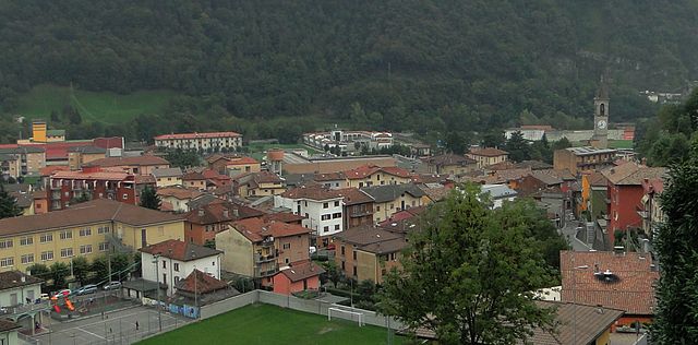
Казниго
- коммуна Италии
Hiking in Казниго
Casnigo is a charming town located in the province of Bergamo, in the Lombardy region of northern Italy. Nestled within the Seriana Valley, it boasts stunning natural scenery, making it an excellent spot for hiking enthusiasts. Here are some key highlights for hiking in and around Casnigo:...
- Страна:
- Почтовый код: 24020
- Телефонный код: 035
- Код автомобильного номера: BG
- Координаты: 45° 48' 59" N, 9° 52' 0" E
- GPS треки (wikiloc): [Ссылка]
- Высота над уровнем моря: 514 м m
- Площадь: 13.62 кв.км
- Население: 3221
- Веб сайт: [Ссылка]


Кольцате
- коммуна Италии
Hiking in Кольцате
Colzate is a charming village located in the Lombardy region of Italy, nestled in the Alps near the Seriana Valley. It's an excellent destination for hikers, offering picturesque landscapes, lush forests, and a variety of trails suitable for different skill levels. Here are some key points to consider when hiking in Colzate:...
- Страна:
- Почтовый код: 24020
- Телефонный код: 035
- Код автомобильного номера: BG
- Координаты: 45° 49' 0" N, 9° 52' 0" E
- GPS треки (wikiloc): [Ссылка]
- Высота над уровнем моря: 424 м m
- Площадь: 6 кв.км
- Население: 1638
- Веб сайт: [Ссылка]


Корнальба
- коммуна Италии
Hiking in Корнальба
Cornalba is a picturesque village located in the Lombardy region of Italy, nestled in the Bergamo Alps. Its stunning landscapes, lush forests, and scenic views make it a fantastic destination for hiking enthusiasts. Here’s what you need to know about hiking in and around Cornalba:...
- Страна:
- Почтовый код: 24017
- Телефонный код: 0345
- Код автомобильного номера: BG
- Координаты: 45° 51' 0" N, 9° 45' 0" E
- GPS треки (wikiloc): [Ссылка]
- Высота над уровнем моря: 893 м m
- Площадь: 9.25 кв.км
- Население: 305
- Веб сайт: [Ссылка]

Коста-Серина
- коммуна Италии
Hiking in Коста-Серина
Costa Serina, located in the province of Bergamo in the Lombardy region of Italy, is a beautiful destination for hiking enthusiasts. Nestled in the scenic foothills of the Alps, it offers a variety of trails that cater to different levels of experience, from casual walkers to seasoned hikers. Here are some key details about hiking in this area:...
- Страна:
- Почтовый код: 24010
- Телефонный код: 0345
- Код автомобильного номера: BG
- Координаты: 45° 49' 58" N, 9° 44' 30" E
- GPS треки (wikiloc): [Ссылка]
- Высота над уровнем моря: 868 м m
- Площадь: 12.3 кв.км
- Население: 912
- Веб сайт: [Ссылка]

Фьорано-аль-Серио
- коммуна Италии
Hiking in Фьорано-аль-Серио
Fiorano al Serio is a charming town located in the province of Bergamo, in the Lombardy region of northern Italy. Surrounded by the stunning natural beauty of the Orobian Alps, it offers a variety of hiking opportunities for both beginners and experienced hikers....
- Страна:
- Почтовый код: 24020
- Телефонный код: 035
- Код автомобильного номера: BG
- Координаты: 45° 48' 7" N, 9° 50' 35" E
- GPS треки (wikiloc): [Ссылка]
- Высота над уровнем моря: 396 м m
- Площадь: 1.06 кв.км
- Население: 3016
- Веб сайт: [Ссылка]


Гаццанига
- коммуна Италии
Hiking in Гаццанига
Gazzaniga, a town located in the Lombardy region of Italy, is surrounded by beautiful natural landscapes that provide fantastic opportunities for hiking enthusiasts. While the town itself may not be a well-known hiking destination, its proximity to the Orobian Alps and the Seriana Valley offers a variety of trails suitable for all levels of hikers....
- Страна:
- Почтовый код: 24025
- Телефонный код: 035
- Код автомобильного номера: BG
- Координаты: 45° 48' 0" N, 9° 50' 0" E
- GPS треки (wikiloc): [Ссылка]
- Высота над уровнем моря: 386 м m
- Площадь: 14.41 кв.км
- Население: 5058
- Веб сайт: [Ссылка]


Онета
- коммуна Италии
Hiking in Онета
Oneta, located in the Lombardy region of Italy, is a picturesque village nestled within the Orobian Alps, making it an excellent spot for hiking enthusiasts. The area boasts stunning landscapes, including lush forests, rocky terrains, and panoramic views of the surrounding mountains....
- Страна:
- Почтовый код: 24020
- Телефонный код: 035
- Код автомобильного номера: BG
- Координаты: 45° 52' 0" N, 9° 49' 0" E
- GPS треки (wikiloc): [Ссылка]
- Высота над уровнем моря: 740 м m
- Площадь: 18.66 кв.км
- Население: 598
- Веб сайт: [Ссылка]