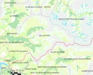
Виллар-Лубьер (Villar-Loubière, Villar-Loubière)
- коммуна во Франции
 Hiking in Виллар-Лубьер
Villar-Loubière is a picturesque village located in the Provence-Alpes-Côte d'Azur region of southeastern France. It’s surrounded by stunning natural landscapes, making it a great destination for hiking enthusiasts.
Hiking Opportunities:
-
Scenic Trails: The area around Villar-Loubière offers a variety of trails suitable for different skill levels, ranging from easy strolls to more challenging hikes. The trails often provide breathtaking views of the surrounding mountains and valleys.
-
Provence Alpes Hiking Trails: This region is part of the Provence Alpes hiking network, which features numerous well-marked trails. Consider exploring paths that take you through the charming countryside, historical sites, and perhaps even local vineyards.
-
Nearby Natural Parks: The Écrins National Park is a short distance from Villar-Loubière. It offers more rugged hikes, with opportunities to encounter diverse flora and fauna, glacial lakes, and dramatic mountain scenery. It’s suitable for experienced hikers looking for adventure.
Recommended Hikes:
-
Circuit autour de Villar-Loubière: A circular route that takes you through the village and surrounding areas, ideal for leisurely hikes while enjoying local scenery.
-
Trek to the Col de la Casse: A more challenging hike that rewards you with panoramic views of the surrounding peaks and valleys. It’s recommended for experienced hikers.
Preparation Tips:
-
Seasonal Considerations: Hiking is best in spring and early autumn when the weather is mild. Summer can be hot, while winter may bring snow, necessitating special gear.
-
Gear: Ensure you have good hiking boots, appropriate clothing for the weather, a map or GPS device, plenty of water, and snacks.
-
Local Knowledge: It can be helpful to connect with local hiking clubs or guides who can provide insights into the best trails and conditions.
Safety:
- Always let someone know your hiking plans, and if you're hiking in remote areas, it's wise to carry a first aid kit and mobile phone.
Conclusion:
Hiking in Villar-Loubière is a rewarding experience for nature lovers and adventurers alike. With its stunning landscapes and a variety of trails, you’re sure to enjoy a memorable time in this charming region of France.
- Страна:

- Почтовый код: 05800
- Координаты: 44° 49' 34" N, 6° 8' 44" E


- GPS треки (wikiloc): [Ссылка]
- Площадь: 22.63 кв.км
- Население: 42
- Википедия русская: wiki(ru)
- Википедия английская: wiki(en)
- Википедия национальная: wiki(fr)
- Хранилище Wikidata: Wikidata: Q1085593
- Катеория в википедии: [Ссылка]
- код Freebase: [/m/03mfncz]
- код Freebase: [/m/03mfncz]
- код GeoNames: Альт: [6425659]
- код GeoNames: Альт: [6425659]
- номер SIREN: [210501821]
- номер SIREN: [210501821]
- код муниципалитета INSEE: 05182
- код муниципалитета INSEE: 05182
Граничит с регионами:

Вальжуффре
- коммуна во Франции
Hiking in Вальжуффре
Valjouffrey is a beautiful and lesser-known hiking destination located in the Isère department of the Auvergne-Rhône-Alpes region in France. Nestled in the heart of the Vercors Massif, Valjouffrey offers stunning landscapes characterized by dramatic peaks, lush valleys, and serene alpine lakes, making it a perfect spot for outdoor enthusiasts....
- Страна:
- Почтовый код: 38740
- Координаты: 44° 52' 20" N, 6° 1' 52" E
- GPS треки (wikiloc): [Ссылка]
- Высота над уровнем моря: 1014 м m
- Площадь: 72.56 кв.км
- Население: 145
- Веб сайт: [Ссылка]

Сен-Морис-ан-Вальгодмар
- коммуна во Франции
Hiking in Сен-Морис-ан-Вальгодмар
Saint-Maurice-en-Valgodemard is a beautiful village located in the French Alps, in the Hautes-Alpes department. Known for its stunning landscapes, it serves as an excellent base for various hiking adventures. Here are some key highlights for hiking in the area:...
- Страна:
- Почтовый код: 05800
- Координаты: 44° 48' 14" N, 6° 5' 44" E
- GPS треки (wikiloc): [Ссылка]
- Площадь: 36.37 кв.км
- Население: 133

Ла-Шапель-ан-Вальгодемар
- коммуна во Франции
Hiking in Ла-Шапель-ан-Вальгодемар
La Chapelle-en-Valgaudémar is a picturesque village located in the heart of the Écrins National Park in the French Alps. This area is renowned for its stunning natural beauty, rugged mountains, and a variety of hiking trails suitable for different skill levels....
- Страна:
- Почтовый код: 05800
- Координаты: 44° 49' 1" N, 6° 11' 41" E
- GPS треки (wikiloc): [Ссылка]
- Высота над уровнем моря: 1050 м m
- Площадь: 108.02 кв.км
- Население: 101