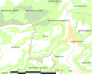
Villars-sous-Dampjoux (Villars-sous-Dampjoux)

- коммуна во Франции
 Hiking in Villars-sous-Dampjoux
Villars-sous-Dampjoux is a charming village located in the Doubs department of France, nestled in the Jura Mountains. The region is known for its stunning natural beauty, making it an excellent spot for hiking enthusiasts.
Hiking Highlights:
-
Scenic Trails: The area features a network of well-marked hiking trails that cater to different skill levels, from easy walks suitable for families to more challenging routes for experienced hikers.
-
Local Flora and Fauna: As you hike, you’ll encounter diverse landscapes including meadows, forests, and rocky outcrops. Keep an eye out for local wildlife, such as deer and various bird species, as well as the unique plant life that flourishes in the Jura region.
-
Breathtaking Views: Hikes often provide panoramic views of the surrounding valleys and mountains. Higher elevations offer breathtaking vantage points ideal for photography or simply enjoying the tranquility of nature.
-
Cultural Points of Interest: Along some trails, you might find local historical sites, such as traditional stone houses, chapels, or remnants of ancient fortifications, adding a cultural dimension to your hiking experience.
-
Seasonal Hiking: The best hiking conditions generally occur from late spring through early autumn. In winter, some trails may be suitable for snowshoeing or cross-country skiing, although this depends on the snow conditions.
Recommendations:
- Prepare Properly: Always check the weather beforehand, wear appropriate footwear, and carry enough water and snacks.
- Trail Maps: Consider obtaining a local map or using a hiking app to help navigate the trails effectively.
- Guided Tours: If you’re new to the area or hiking, look for local guides who can provide insights into the trails and the natural environment.
Overall, hiking in Villars-sous-Dampjoux offers a wonderful opportunity to connect with nature, explore beautiful landscapes, and enjoy the serene atmosphere of the Jura Mountains.
- Страна:

- Почтовый код: 25190
- Координаты: 47° 20' 57" N, 6° 45' 24" E


- GPS треки (wikiloc): [Ссылка]
- Площадь: 3.06 кв.км
- Население: 367
- Википедия английская: wiki(en)
- Википедия национальная: wiki(fr)
- Хранилище Wikidata: Wikidata: Q906999
- Катеория в википедии: [Ссылка]
- код Freebase: [/m/03mgbnm]
- код GeoNames: Альт: [6430050]
- номер SIREN: [212506174]
- код BNF: [152528436]
- код тезауруса PACTOLS: [pcrtDIRSLM3FQP]
- код муниципалитета INSEE: 25617
Граничит с регионами:


Noirefontaine
- коммуна во Франции
Hiking in Noirefontaine
Noirefontaine is an area in the French region of Auvergne-Rhône-Alpes, known for its scenic beauty and great opportunities for hiking. This region boasts a mix of lush forests, rolling hills, and picturesque landscapes, making it an ideal destination for outdoor enthusiasts....
- Страна:
- Почтовый код: 25190
- Координаты: 47° 20' 56" N, 6° 45' 43" E
- GPS треки (wikiloc): [Ссылка]
- Площадь: 3.35 кв.км
- Население: 396


Dampjoux
- коммуна во Франции
Hiking in Dampjoux
Dampjoux, a beautiful area located in the French Alps, offers a stunning backdrop for hiking enthusiasts. This region is known for its diverse landscapes, ranging from lush valleys to impressive mountain peaks. Here are some key points to consider when planning a hike in Dampjoux:...
- Страна:
- Почтовый код: 25190
- Координаты: 47° 20' 34" N, 6° 45' 27" E
- GPS треки (wikiloc): [Ссылка]
- Площадь: 2.31 кв.км
- Население: 179


Pont-de-Roide-Vermondans
- коммуна во Франции
Hiking in Pont-de-Roide-Vermondans
Pont-de-Roide-Vermondans is a picturesque area located in the Doubs department in the Bourgogne-Franche-Comté region of France. It's known for its natural beauty and landscapes, making it a great destination for hiking enthusiasts. Here are some details to consider when hiking in this area:...
- Страна:
- Почтовый код: 25150
- Координаты: 47° 23' 5" N, 6° 46' 12" E
- GPS треки (wikiloc): [Ссылка]
- Площадь: 13.58 кв.км
- Население: 4215
- Веб сайт: [Ссылка]


Neuchâtel-Urtière
- коммуна во Франции
Hiking in Neuchâtel-Urtière
Neuchâtel-Urtière, located in the Canton of Neuchâtel in Switzerland, offers some beautiful hiking opportunities in a picturesque setting. The region features a combination of rolling hills, dense forests, and stunning views of Lake Neuchâtel and the surrounding Jura mountain range....
- Страна:
- Почтовый код: 25150
- Координаты: 47° 22' 29" N, 6° 43' 49" E
- GPS треки (wikiloc): [Ссылка]
- Площадь: 6.21 кв.км
- Население: 185

Feule
- коммуна во Франции
Hiking in Feule
It seems like there might be a typo in your request, as "Feule" doesn’t appear to be a well-known hiking destination. If you meant "Fjäll" (which refers to mountain ranges in Scandinavia) or perhaps you’re looking for hiking information in a specific area that sounds similar, please clarify or provide more details....
- Страна:
- Почтовый код: 25190
- Координаты: 47° 20' 41" N, 6° 43' 59" E
- GPS треки (wikiloc): [Ссылка]
- Площадь: 3.76 кв.км
- Население: 182