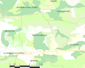
Villefranche-le-Château (Villefranche-le-Château)

- коммуна во Франции
 Hiking in Villefranche-le-Château
Villefranche-le-Château, located in the beautiful region of France, offers a variety of hiking opportunities amidst picturesque landscapes. The surrounding areas are characterized by rolling hills, dense forests, and charming rural settings, making it a great destination for outdoor enthusiasts.
Hiking Trails
-
Local Trails: Numerous local trails vary in difficulty, catering to both beginners and experienced hikers. Many paths wind through woods and fields, providing a chance to enjoy the natural scenery and possibly spot wildlife.
-
Circuit de la Cascade: A popular route that often features streams and small waterfalls. The trails are usually well-marked, offering a moderate hike that can be enjoyed by families.
-
Sentier des Grands Éboulis: This longer trail is suited for those looking for a more challenging hike. Make sure to check the trail conditions and be prepared for some elevation gains.
Tips for Hiking in Villefranche-le-Château
- Preparation: Always prepare for your hike by checking the weather, and packing enough water, snacks, and a first aid kit.
- Navigation: Consider carrying a map or a GPS device, as some trails might not be well-marked.
- Timing: Plan your hike for early in the day or late afternoon to enjoy cooler temperatures and fewer crowds.
- Respect Nature: Stay on designated paths, take your trash back with you, and respect the wildlife.
Nearby Attractions
After your hike, you might want to explore local attractions such as historical sites, charming villages, and regional restaurants featuring local cuisine. This may enhance your hiking experience and provide a full day of exploration.
Overall, hiking in Villefranche-le-Château can be a refreshing way to enjoy nature while exploring the beauty of the French countryside. Always remember to hike responsibly and enjoy the adventure!
- Страна:

- Почтовый код: 26560
- Координаты: 44° 13' 16" N, 5° 31' 21" E


- GPS треки (wikiloc): [Ссылка]
- Площадь: 7.42 кв.км
- Население: 24
- Википедия английская: wiki(en)
- Википедия национальная: wiki(fr)
- Хранилище Wikidata: Wikidata: Q313406
- Катеория в википедии: [Ссылка]
- код Freebase: [/m/03mhm00]
- код GeoNames: Альт: [6430272]
- номер SIREN: [212603757]
- код BNF: [152532355]
- код муниципалитета INSEE: 26375
Граничит с регионами:


Séderon
- коммуна во Франции
Hiking in Séderon
Séderon is a picturesque village located in the Drôme region of southeastern France, known for its stunning landscapes and hiking opportunities. The surrounding area offers a variety of trails that cater to different skill levels and interests, making it an ideal destination for both casual walkers and experienced hikers....
- Страна:
- Почтовый код: 26560
- Координаты: 44° 12' 16" N, 5° 32' 14" E
- GPS треки (wikiloc): [Ссылка]
- Площадь: 20.3 кв.км
- Население: 272

Vers-sur-Méouge
- коммуна во Франции
Hiking in Vers-sur-Méouge
Vers-sur-Méouge is a charming village located in the Drôme department in southeastern France, known for its natural beauty and outdoor activities, particularly hiking. The surrounding region features stunning landscapes, including the picturesque Méouge River, limestone cliffs, and the scenic backdrop of the Baronnies Provençales Natural Regional Park....
- Страна:
- Почтовый код: 26560
- Координаты: 44° 13' 51" N, 5° 34' 14" E
- GPS треки (wikiloc): [Ссылка]
- Площадь: 13.81 кв.км
- Население: 47


Barret-de-Lioure
- коммуна во Франции
Hiking in Barret-de-Lioure
Barret-de-Lioure is a picturesque village located in the Drôme department of southeastern France. It is surrounded by stunning natural landscapes that provide excellent opportunities for hiking and outdoor activities. Here are some key points to consider if you're planning a hiking trip in or around Barret-de-Lioure:...
- Страна:
- Почтовый код: 26570
- Координаты: 44° 11' 10" N, 5° 29' 37" E
- GPS треки (wikiloc): [Ссылка]
- Площадь: 34.64 кв.км
- Население: 86


Mévouillon
- коммуна во Франции
Hiking in Mévouillon
Mévouillon is a small village located in the Drôme department of southeastern France, nestled in the picturesque landscapes of the Provençal countryside. This region is known for its beautiful hiking trails that offer both seasoned hikers and casual walkers an opportunity to explore its natural beauty....
- Страна:
- Почтовый код: 26560
- Координаты: 44° 14' 30" N, 5° 27' 52" E
- GPS треки (wikiloc): [Ссылка]
- Площадь: 29.09 кв.км
- Население: 246