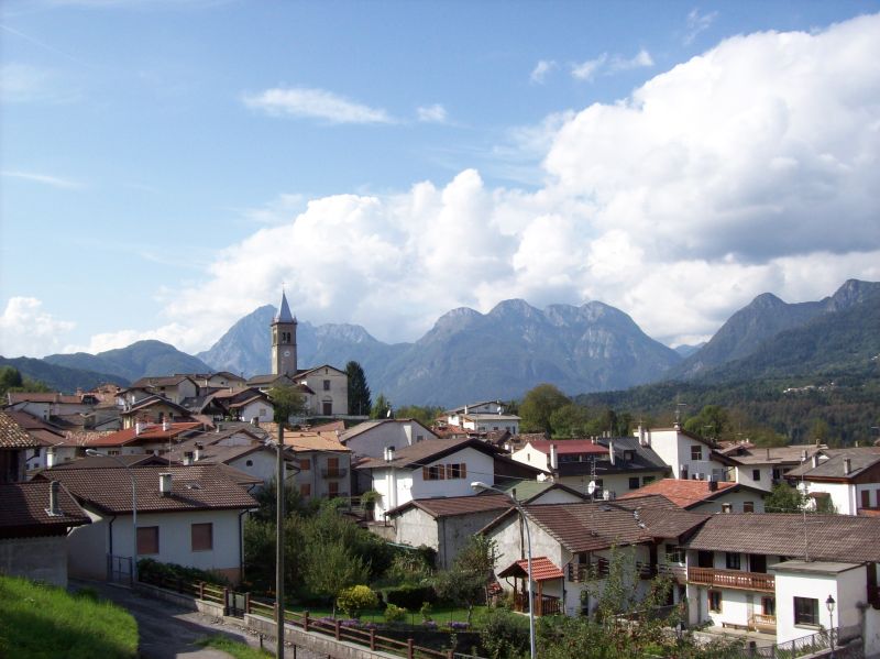
Вито-д'Азио (Vito d'Asio, Vito d'Asio)
.svg)
- коммуна Италии
 Hiking in Вито-д'Азио
Vito d'Asio is a picturesque village located in the Friuli Venezia Giulia region of northern Italy. Surrounded by the beautiful landscapes of the eastern Alps, this area offers various hiking opportunities for both beginners and experienced hikers. Here are some highlights and tips for hiking in Vito d'Asio:
Trails and Routes:
-
Local Trails: The region around Vito d'Asio has numerous marked trails that lead through forests, meadows, and hills. You can explore routes that showcase the stunning views of the surrounding mountains and valleys.
-
Sentiero dei Gelsi: This is a scenic path that often attracts hikers, featuring beautiful views and a relatively easy terrain. It’s great for families or those looking for a leisurely hike.
-
Wildlife Observation: The area is rich in biodiversity. Keep an eye out for local wildlife including various bird species, deer, and other animals native to the Friuli region.
-
Cultural Stops: Along some trails, you might encounter small chapels, traditional farmhouses, and other points of interest that highlight the local culture and history.
Best Time to Hike:
- Spring and Fall: These seasons are ideal due to mild temperatures and stunning natural colors. In spring, you can witness the bloom of wildflowers; in autumn, the foliage provides a vibrant backdrop.
- Summer: Although hiking is popular in the summer months, be prepared for warmer temperatures and consider starting early in the day to avoid the heat.
Preparation:
- Trail Maps: It's a good practice to obtain a trail map or use GPS apps to navigate the area effectively. Local tourism offices can provide valuable resources.
- Gear: Wear sturdy hiking boots and dress in layers. Always pack essentials such as water, snacks, a first-aid kit, and a fully charged phone.
- Weather: Check the weather forecast before heading out and be prepared for rapid changes in weather conditions in mountainous areas.
Safety Tips:
- Inform someone about your hiking plans and expected return time.
- Stay on marked trails to protect the local flora and fauna.
- Hydrate frequently, especially on warmer days.
Local Guidance:
For those unfamiliar with the area, consider hiring a local guide who can provide insights into the best trails and hidden gems while ensuring safety on the routes.
Vito d'Asio offers a captivating blend of nature and culture, making it a wonderful destination for outdoor enthusiasts looking to experience the beauty of northern Italy. Enjoy your hike!
- Страна:

- Почтовый код: 33090
- Телефонный код: 0427
- Код автомобильного номера: PN
- Координаты: 46° 14' 0" N, 12° 56' 0" E


- GPS треки (wikiloc): [Ссылка]
- Высота над уровнем моря: 381 м m
- Площадь: 53.72 кв.км
- Население: 734
- Веб сайт: http://www.comune.vitodasio.pn.it
- Википедия русская: wiki(ru)
- Википедия английская: wiki(en)
- Википедия национальная: wiki(it)
- Хранилище Wikidata: Wikidata: Q53204
- Катеория в википедии: [Ссылка]
- код Freebase: [/m/0gqzws]
- код GeoNames: Альт: [6536343]
- код VIAF: Альт: [248319062]
- ID отношения в OpenStreetMap: [79084]
- место в MusicBrainz: [a49b947c-920c-421d-b6af-0d151552ec82]
- код ISTAT: 093049
- кадастровый код Италии: M085
Граничит с регионами:
Кастельново-дель-Фриули
- коммуна Италии
Hiking in Кастельново-дель-Фриули
Castelnovo del Friuli is a charming municipality located in the Friuli Venezia Giulia region of northern Italy. It's an excellent destination for hiking enthusiasts, as it offers a variety of landscapes, including hills, forests, and stunning views of the surrounding mountains....
- Страна:
- Почтовый код: 33090
- Телефонный код: 0427
- Код автомобильного номера: PN
- Координаты: 46° 12' 31" N, 12° 53' 37" E
- GPS треки (wikiloc): [Ссылка]
- Высота над уровнем моря: 244 м m
- Площадь: 22.48 кв.км
- Население: 864
- Веб сайт: [Ссылка]
Клауцетто
- коммуна Италии
Hiking in Клауцетто
Clauzetto is a picturesque village located in the province of Pordenone in the Friuli Venezia Giulia region of Italy. Surrounded by beautiful natural landscapes, it offers various hiking opportunities perfect for outdoor enthusiasts....
- Страна:
- Почтовый код: 33090
- Телефонный код: 0427
- Код автомобильного номера: PN
- Координаты: 46° 14' 0" N, 12° 55' 0" E
- GPS треки (wikiloc): [Ссылка]
- Высота над уровнем моря: 454 м m
- Площадь: 28.31 кв.км
- Население: 380
- Веб сайт: [Ссылка]


Пинцано-аль-Тальяменто
- коммуна Италии
Hiking in Пинцано-аль-Тальяменто
Pinzano al Tagliamento, located in the Friuli Venezia Giulia region of northeastern Italy, is an excellent destination for hiking enthusiasts. The area is characterized by its stunning natural landscapes, including rolling hills, the Tagliamento River, and lush forests....
- Страна:
- Почтовый код: 33094
- Телефонный код: 0432
- Код автомобильного номера: PN
- Координаты: 46° 10' 59" N, 12° 56' 43" E
- GPS треки (wikiloc): [Ссылка]
- Высота над уровнем моря: 201 м m
- Площадь: 21.95 кв.км
- Население: 1514
- Веб сайт: [Ссылка]


Трамонти-ди-Сотто
- коммуна Италии
Hiking in Трамонти-ди-Сотто
Tramonti di Sotto is a picturesque village located in the Friuli Venezia Giulia region of northeastern Italy, nestled within the Julian Alps. The area is known for its natural beauty, offering a range of hiking opportunities suitable for various skill levels. Here are some highlights of hiking in the region:...
- Страна:
- Почтовый код: 33090
- Телефонный код: 0427
- Код автомобильного номера: PN
- Координаты: 46° 17' 0" N, 12° 48' 0" E
- GPS треки (wikiloc): [Ссылка]
- Высота над уровнем моря: 366 м m
- Площадь: 85.55 кв.км
- Население: 367
- Веб сайт: [Ссылка]


Каваццо-Карнико
- коммуна Италии
Hiking in Каваццо-Карнико
Cavazzo Carnico, located in the Friuli Venezia Giulia region of northeastern Italy, is a fantastic destination for hiking enthusiasts. Nestled between the beautiful Julian Alps and the Carnic Alps, the area is known for its stunning landscapes, diverse flora and fauna, and rich cultural heritage....
- Страна:
- Почтовый код: 33020
- Телефонный код: 0433
- Код автомобильного номера: UD
- Координаты: 46° 22' 0" N, 13° 2' 0" E
- GPS треки (wikiloc): [Ссылка]
- Высота над уровнем моря: 290 м m
- Площадь: 39.44 кв.км
- Население: 1024
- Веб сайт: [Ссылка]


Форгария-нель-Фриули
- коммуна Италии
Hiking in Форгария-нель-Фриули
Forgaria nel Friuli is a picturesque town located in the Friuli-Venezia Giulia region of Italy. Nestled near the eastern foothills of the Carnic Alps, it offers a range of hiking opportunities suitable for various skill levels. Here are some highlights of hiking in this area:...
- Страна:
- Почтовый код: 33030
- Телефонный код: 0427
- Код автомобильного номера: UD
- Координаты: 46° 13' 0" N, 12° 58' 0" E
- GPS треки (wikiloc): [Ссылка]
- Высота над уровнем моря: 270 м m
- Площадь: 28.94 кв.км
- Население: 1773
- Веб сайт: [Ссылка]

Преоне
- коммуна Италии
Hiking in Преоне
Preone is a picturesque village located in the Friuli Venezia Giulia region of Italy, nestled in the foothills of the Carnic Alps. This area offers a variety of hiking opportunities suitable for different skill levels, surrounded by breathtaking landscapes, rich flora and fauna, and stunning mountain views....
- Страна:
- Почтовый код: 33020
- Телефонный код: 0433
- Код автомобильного номера: UD
- Координаты: 46° 24' 0" N, 12° 52' 0" E
- GPS треки (wikiloc): [Ссылка]
- Высота над уровнем моря: 461 м m
- Площадь: 22.47 кв.км
- Население: 234
- Веб сайт: [Ссылка]


Тразагис
- коммуна Италии
Hiking in Тразагис
Trasaghis, located in the Friuli Venezia Giulia region of northeastern Italy, is an excellent destination for hiking enthusiasts. The area is known for its stunning natural landscapes, characterized by lush forests, picturesque valleys, and serene lakes. Here are some key points to consider when hiking in Trasaghis:...
- Страна:
- Почтовый код: 33010
- Телефонный код: 0432
- Код автомобильного номера: UD
- Координаты: 46° 17' 0" N, 13° 5' 0" E
- GPS треки (wikiloc): [Ссылка]
- Высота над уровнем моря: 217 м m
- Площадь: 77.85 кв.км
- Население: 2222
- Веб сайт: [Ссылка]


Верцегнис
- коммуна Италии
Hiking in Верцегнис
Verzegnis is a picturesque village located in the Friuli Venezia Giulia region of northeastern Italy. It's nestled in the Carnic Alps, which offer stunning landscapes, rich biodiversity, and a variety of hiking opportunities suitable for all levels of experience....
- Страна:
- Почтовый код: 33020
- Телефонный код: 0433
- Код автомобильного номера: UD
- Координаты: 46° 22' 59" N, 12° 58' 33" E
- GPS треки (wikiloc): [Ссылка]
- Высота над уровнем моря: 407 м m
- Площадь: 39.33 кв.км
- Население: 863
- Веб сайт: [Ссылка]