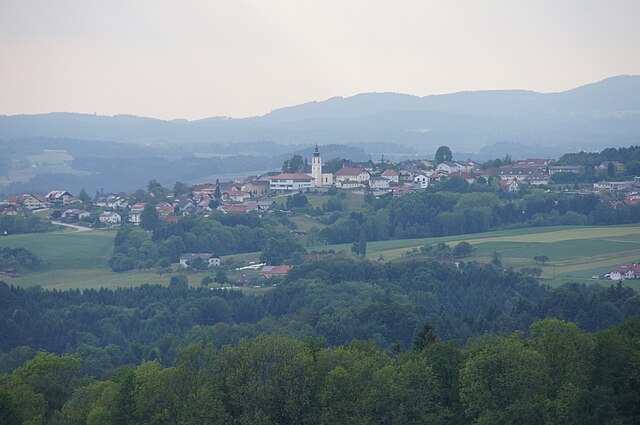
Вайценкирхен (Waizenkirchen, Waizenkirchen)
 Hiking in Вайценкирхен
Waizenkirchen is a picturesque village located in Austria, surrounded by the beautiful countryside of Upper Austria. While it might not be one of the most famous hiking destinations, it offers several opportunities for hikers to explore nature and enjoy the stunning landscapes.
Hiking Trails
-
Local Nature Trails: There are several marked trails around Waizenkirchen that vary in difficulty. These trails typically wind through forests, fields, and along rivers, offering views of the local flora and fauna.
-
Scenic Views: As you hike, you can expect to find breathtaking views of the surrounding hills and valleys. The area is rich in biodiversity, so bring your binoculars for birdwatching.
-
Historical Trails: Some paths take you past historical sites or agricultural lands, providing insight into local history and culture.
Preparation Tips
- Footwear: Ensure you wear good hiking boots for comfort and support, especially if you choose more challenging trails.
- Weather: Check the weather beforehand. Conditions can change rapidly, so dress in layers and bring rain gear if necessary.
- Water and Snacks: Carry enough water and some snacks, particularly if you plan on doing a longer hike.
Local Amenities
- Accommodation: If you’re looking to extend your stay, check local guesthouses or hotels for accommodation options.
- Transportation: Waizenkirchen is accessible by car and local transport. If you’re traveling from larger cities, it may be convenient to have your own vehicle for easier access to hiking spots.
Best Time to Hike
The best time for hiking in Waizenkirchen is typically spring and autumn when the weather is mild, and the natural scenery is at its most vibrant. Summer can also be great, but be prepared for warmer temperatures.
Conclusion
Hiking in Waizenkirchen can be a rewarding experience for those who enjoy tranquil, nature-rich environments. Whether you’re a novice or an experienced hiker, you can find trails that suit your level and offer a chance to unwind and enjoy the beauty of the Upper Austrian countryside. Happy hiking!
- Страна:

- Почтовый код: 4730
- Телефонный код: 07277
- Код автомобильного номера: GR
- Координаты: 48° 19' 49" N, 13° 51' 30" E


- GPS треки (wikiloc): [Ссылка]
- Высота над уровнем моря: 367 м m
- Площадь: 34.2 кв.км
- Население: 3729
- Веб сайт: http://www.waizenkirchen.at/
- Википедия русская: wiki(ru)
- Википедия английская: wiki(en)
- Википедия национальная: wiki(de)
- Хранилище Wikidata: Wikidata: Q681309
- Катеория в википедии: [Ссылка]
- код Freebase: [/m/03gv5n0]
- код GeoNames: Альт: [2762060]
- код VIAF: Альт: [234705763]
- код GND: Альт: [4270394-3]
- место в MusicBrainz: [fb882091-7d5a-44a6-8117-3321b74bc4c2]
- WOEID: [547178]
- код австрийского муниципалитета: [40831]
Граничит с регионами:

Пойербах
Hiking in Пойербах
Peuerbach, a small town in Upper Austria, offers a charming environment for hiking enthusiasts. Surrounded by beautiful landscapes, rolling hills, and lush greenery, it's an excellent destination for both beginner and experienced hikers....
- Страна:
- Почтовый код: 4722
- Телефонный код: 07276
- Код автомобильного номера: GR
- Координаты: 48° 20' 44" N, 13° 46' 27" E
- GPS треки (wikiloc): [Ссылка]
- Высота над уровнем моря: 390 м m
- Площадь: 39.4 кв.км
- Население: 4483
- Веб сайт: [Ссылка]

Штрохайм
Hiking in Штрохайм
It seems there might be some confusion, as "Stroheim" doesn't refer to a widely recognized hiking destination. It could be a lesser-known area or perhaps a misspelling or miscommunication about a specific location....
- Страна:
- Почтовый код: 4074
- Телефонный код: 07272
- Код автомобильного номера: EF
- Координаты: 48° 20' 20" N, 13° 57' 30" E
- GPS треки (wikiloc): [Ссылка]
- Высота над уровнем моря: 489 м m
- Площадь: 28.75 кв.км
- Население: 1555
- Веб сайт: [Ссылка]

Прамбахкирхен
Hiking in Прамбахкирхен
Prambachkirchen, a charming town located in the Upper Austria region, offers a wonderful backdrop for hiking enthusiasts looking to explore the scenic landscapes of Austria. The area is characterized by rolling hills, lush forests, and picturesque views that make it a great destination for both casual walkers and seasoned hikers....
- Страна:
- Почтовый код: 4731
- Телефонный код: 07277
- Код автомобильного номера: EF
- Координаты: 48° 19' 0" N, 13° 54' 0" E
- GPS треки (wikiloc): [Ссылка]
- Высота над уровнем моря: 374 м m
- Площадь: 28.73 кв.км
- Население: 2919
- Веб сайт: [Ссылка]
Михельнбах
Hiking in Михельнбах
Michaelnbach is a small village located in Austria, surrounded by beautiful natural landscapes that are perfect for hiking. The area typically offers a variety of hiking trails suitable for different skill levels, from easy walks to more challenging treks....
- Страна:
- Почтовый код: 4712
- Телефонный код: 07277
- Код автомобильного номера: GR
- Координаты: 48° 17' 19" N, 13° 49' 57" E
- GPS треки (wikiloc): [Ссылка]
- Высота над уровнем моря: 394 м m
- Площадь: 12.16 кв.км
- Население: 1263
- Веб сайт: [Ссылка]
Хайлигенберг
Hiking in Хайлигенберг
Heiligenberg, nestled in Austria, offers an array of picturesque hiking trails that cater to various skill levels. The region is characterized by its lush landscapes, rolling hills, and scenic views, making it a great destination for both novice hikers and experienced outdoors enthusiasts....
- Страна:
- Почтовый код: 4733
- Телефонный код: 07277
- Код автомобильного номера: GR
- Координаты: 48° 21' 18" N, 13° 49' 23" E
- GPS треки (wikiloc): [Ссылка]
- Высота над уровнем моря: 398 м m
- Площадь: 13.86 кв.км
- Население: 691
- Веб сайт: [Ссылка]
Санкт-Агата
Hiking in Санкт-Агата
Sankt Agatha, located in Austria, is a charming village that offers a range of hiking opportunities suitable for various skill levels. The surrounding landscape features picturesque valleys, rolling hills, and lush forests, making it a beautiful destination for nature enthusiasts....
- Страна:
- Почтовый код: 4084
- Телефонный код: 07277
- Код автомобильного номера: GR
- Координаты: 48° 23' 10" N, 13° 52' 44" E
- GPS треки (wikiloc): [Ссылка]
- Высота над уровнем моря: 603 м m
- Площадь: 31.8 кв.км
- Население: 2116
- Веб сайт: [Ссылка]