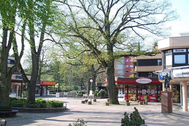
Вандсбек (Wandsbek, Bezirk Wandsbek)

- район в Гамбурге
 Hiking in Вандсбек
Wandsbek is a district in Hamburg, Germany, known more for its urban landscape than traditional hiking trails. However, there are several parks, nature reserves, and green spaces where you can enjoy walking and light hiking activities. Here are some highlights for hiking and outdoor exploration in the Wandsbek area:
-
Wandsbeker Gehölz: This is a large park and woodland area that offers various walking paths. It’s a great place for leisurely hikes or nature walks, surrounded by trees and greenery.
-
Hamburg-Damm: This area has paths that are suitable for hiking and biking, allowing you to take in the sights and sounds of nature while enjoying some physical activity.
-
Schwarzer Weg: A beautiful path that runs along the canals in the district, providing opportunities for walking and connecting with nature.
-
Shopping and Walking: If you’re looking for a combination of urban exploration and walking, the Wandsbek Quarree shopping mall area offers pedestrian-friendly paths and places for a nice stroll.
-
Public Transport Links: Wandsbek is well-connected to other parts of Hamburg, making it easy to access larger parks and nature reserves nearby, such as the Alster Lakes or the Stadtpark, which offer more extensive hiking opportunities.
Overall, while Wandsbek might not be a traditional hiking destination with rugged trails, it can still provide enjoyable walks in beautiful green spaces. If you’re looking for more serious hiking, consider traveling to areas outside the city that are known for extensive trails, such as the Lüneburg Heath or the Harz Mountains.
- Страна:

- Телефонный код: 040
- Координаты: 53° 35' 0" N, 10° 5' 0" E


- GPS треки (wikiloc): [Ссылка]
- Площадь: 147.5 кв.км
- Население: 435235
- Веб сайт: http://www.hamburg.de/wandsbek
- Википедия русская: wiki(ru)
- Википедия английская: wiki(en)
- Википедия национальная: wiki(de)
- Хранилище Wikidata: Wikidata: Q1633
- Катеория в википедии: [Ссылка]
- код Freebase: [/m/091y6f]
- ID отношения в OpenStreetMap: [30353]
- идентификатор местоположения ArchINFORM: [44666]
- код в энциклопедии «Британника онлайн»: [place/Wandsbek]
Включает регионы:


Айльбек
- часть района Вандсбек, Гамбург, Германия
Hiking in Айльбек
Eilbek is a district in Hamburg, Germany, primarily known for its residential areas and urban atmosphere rather than conventional hiking trails. However, there are several ways to enjoy outdoor activities and explore nature in and around Eilbek:...
- Страна:
- Координаты: 53° 34' 4" N, 10° 2' 44" E
- GPS треки (wikiloc): [Ссылка]
- Высота над уровнем моря: 16 м m
- Площадь: 1.7 кв.км
- Население: 20265


Фармзен-Берне
- часть района Вандсбек, Гамбург, Германия
Hiking in Фармзен-Берне
Farmsen-Berne is a district located in Hamburg, Germany, known for its suburban vibe and green spaces. While it may not be a traditional hiking destination like national parks or mountainous areas, there are still opportunities for outdoor walks and nature exploration in and around this area....
- Страна:
- Почтовый код: 22159
- Телефонный код: 040
- Координаты: 53° 36' 23" N, 10° 7' 11" E
- GPS треки (wikiloc): [Ссылка]
- Высота над уровнем моря: 22 м m
- Площадь: 8.3 кв.км
- Население: 34752
Енфельд
- часть района Вандсбек, Гамбург, Германия
Hiking in Енфельд
Jenfeld is a district in Hamburg, Germany, known more for its residential areas than for traditional hiking trails. However, there are still opportunities for walking and enjoying nature in and around the area, particularly in nearby parks and green spaces. Here are some options for exploring the outdoors near Jenfeld:...
- Страна:
- Почтовый код: 22045; 22043
- Телефонный код: 040
- Координаты: 53° 34' 20" N, 10° 8' 10" E
- GPS треки (wikiloc): [Ссылка]
- Площадь: 5.0 кв.км
- Население: 26238
Маринталь
- часть района Вандсбек, Гамбург, Германия
Hiking in Маринталь
Hamburg-Marienthal is a quiet neighborhood in Hamburg, Germany, known for its residential areas and green spaces. While it might not be a traditional hiking hotspot like nearby national parks, there are several pleasant walking paths and nature areas that cater to both casual walkers and those looking for a bit more adventure....
- Страна:
- Координаты: 53° 34' 8" N, 10° 5' 9" E
- GPS треки (wikiloc): [Ссылка]
- Площадь: 3.3 кв.км


Тондорф
- Часть Вандсбека, района Гамбурга, Германия
Hiking in Тондорф
Hamburg-Tonndorf is a relatively quiet district located in the eastern part of Hamburg, Germany. While it's more urban compared to some of the more rural hiking areas in the region, there are still opportunities for enjoyable hikes and nature walks. Here are some highlights and tips for hiking in and around Tonndorf:...
- Страна:
- Почтовый код: 22041; 22047; 22045
- Координаты: 53° 35' 10" N, 10° 7' 29" E
- GPS треки (wikiloc): [Ссылка]
- Площадь: 3.9 кв.км
- Население: 14812
Фольксдорф
- квартал Гамбурга
Hiking in Фольксдорф
Volksdorf, a quaint and charming district located in the northeast of Hamburg, Germany, offers a unique opportunity for hiking enthusiasts. The area is characterized by its beautiful countryside, quaint residential streets, and access to various nature reserves, making it a fantastic spot for both casual walks and more extensive hiking excursions....
- Страна:
- Координаты: 53° 38' 59" N, 10° 11' 3" E
- GPS треки (wikiloc): [Ссылка]
- Высота над уровнем моря: 49 м m
- Площадь: 11.6 кв.км


Вандсбек
- квартал Гамбурга
Hiking in Вандсбек
Wandsbek, a borough in Hamburg, Germany, is not typically known for extensive hiking trails, as it is more urban than rural. However, there are still opportunities for walking and enjoying nature within this area. Here are some highlights for hiking and outdoor activities in and around Wandsbek:...
- Страна:
- Координаты: 53° 34' 55" N, 10° 5' 3" E
- GPS треки (wikiloc): [Ссылка]
- Высота над уровнем моря: 18 м m
- Площадь: 6 кв.км
- Население: 35468
- Веб сайт: [Ссылка]


Вольдорф-Ольштедт
- квартал Гамбурга
Hiking in Вольдорф-Ольштедт
Wohldorf-Ohlstedt is a scenic area located on the northern outskirts of Hamburg, Germany. It's known for its lush green landscapes, charming recreational paths, and serene forests, making it an excellent destination for hiking enthusiasts. Here are some highlights and tips for hiking in Wohldorf-Ohlstedt:...
- Страна:
- Почтовый код: 22397
- Телефонный код: 040
- Координаты: 53° 41' 34" N, 10° 7' 52" E
- GPS треки (wikiloc): [Ссылка]
- Высота над уровнем моря: 30 м m
- Площадь: 17.3 кв.км
- Население: 4585
Граничит с регионами:

Гамбург-Митте
- район Гамбурга
Hiking in Гамбург-Митте
Hiking in Hamburg-Mitte offers a unique blend of urban exploration, historical sites, and beautiful green spaces. While the area is predominantly urban, there are several parks and nature areas where you can enjoy some fresh air and scenic views. Here are a few highlights and suggestions for hiking and outdoor activities in Hamburg-Mitte:...
- Страна:
- Координаты: 53° 33' 1" N, 9° 59' 39" E
- GPS треки (wikiloc): [Ссылка]
- Высота над уровнем моря: 11 м m
- Площадь: 142.2 кв.км
- Население: 301550


Северный Гамбург
- район Гамбурга
Hiking in Северный Гамбург
Hamburg-Nord, a district of Hamburg, Germany, offers several outdoor activities and green spaces suitable for hiking. While it might not have the extensive mountain trails found in more rural areas, there are still numerous paths and parks to explore, making it a pleasant area for walks and light hiking....
- Страна:
- Координаты: 53° 37' 0" N, 10° 0' 0" E
- GPS треки (wikiloc): [Ссылка]
- Высота над уровнем моря: 11 м m
- Площадь: 57.5 кв.км
- Веб сайт: [Ссылка]
Зегеберг
- район в Германии
Hiking in Зегеберг
Segeberg, located in Schleswig-Holstein, Germany, offers a variety of hiking opportunities amidst its beautiful natural landscapes. The area is renowned for its rolling hills, dense forests, and picturesque lakes, making it a great destination for outdoor enthusiasts....
- Страна:
- Код автомобильного номера: SE
- Координаты: 53° 55' 12" N, 10° 10' 12" E
- GPS треки (wikiloc): [Ссылка]
- Высота над уровнем моря: 37 м m
- Площадь: 1344.39 кв.км
- Население: 272235
- Веб сайт: [Ссылка]

Штормарн
- район в Шлезвиг-Гольштейне, Германия
Hiking in Штормарн
Stormarn is a district in the federal state of Schleswig-Holstein, Germany, known for its beautiful landscapes, lush forests, and charming villages. Hiking in this area offers a variety of trails suitable for all levels of experience, catering to both casual walkers and avid trekkers. Here are some highlights and tips for hiking in Stormarn:...
- Страна:
- Код автомобильного номера: OD
- Координаты: 53° 45' 0" N, 10° 19' 48" E
- GPS треки (wikiloc): [Ссылка]
- Высота над уровнем моря: 34 м m
- Площадь: 766.33 кв.км
- Население: 236705
- Веб сайт: [Ссылка]