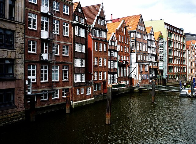
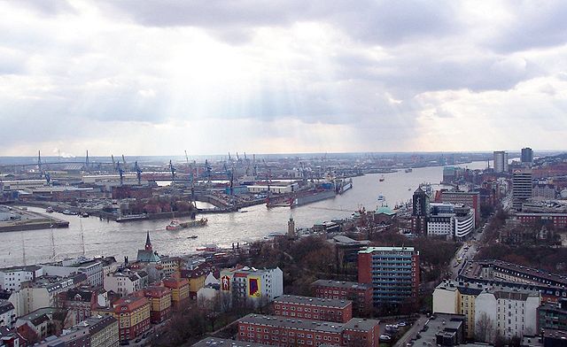
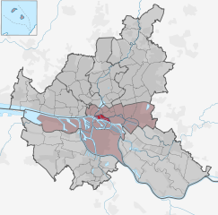
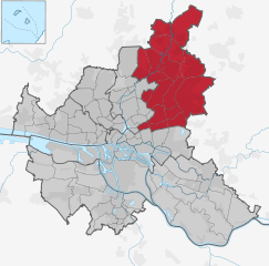
Гамбург-Митте (Hamburg-Mitte, Bezirk Hamburg-Mitte)

- район Гамбурга
 Hiking in Гамбург-Митте
Hiking in Hamburg-Mitte offers a unique blend of urban exploration, historical sites, and beautiful green spaces. While the area is predominantly urban, there are several parks and nature areas where you can enjoy some fresh air and scenic views. Here are a few highlights and suggestions for hiking and outdoor activities in Hamburg-Mitte:
-
Planten un Blomen: This large park in the heart of Hamburg is great for a leisurely walk. The park features beautifully landscaped areas, traditional Japanese gardens, and ponds. There are numerous walking paths where you can explore the park’s rich flora and fauna.
-
Alster river paths: The Outer Alster Lake (Aussenalster) and the Inner Alster Lake (Binnenalster) are situated just north of the more urbanized parts of Hamburg-Mitte. There are scenic walking and cycling paths around both lakes, allowing you to enjoy views of the water, passing boats, and the surrounding cityscape. The route around the Outer Alster is particularly popular for longer walks and jogs, stretching approximately 7 kilometers.
-
Harbour and Speicherstadt: The historic warehouse district (Speicherstadt) and the nearby harbour offer a unique urban hiking experience. You can wander along the waterfront, observe the bustling port activity, and marvel at the red-brick architecture. The canals and bridges create a picturesque route that feels different from traditional hiking.
-
Stadtpark: Situated a bit northeast of Hamburg-Mitte, Stadtpark is accessible and offers extensive trails through lush greenery, open fields, and even a small lake. It's a perfect spot for walking, picnicking, and a bit of relaxation.
-
Oevelgönne Beach: If you venture a little further towards the Elbe River, Oevelgönne Beach presents a nice area for walking along the riverbank. The beach-side promenade allows you to enjoy views across the river, especially during sunset.
-
Nature reserves: While Hamburg-Mitte is more urban, nearby areas such as the “Hamburg-Wandsbek” or “Boberger Dünen” nature reserves offer hiking trails through natural settings. These reserves would typically require a short public transport ride but are well worth it if you want to explore more natural environments.
-
Guided walking tours: Consider joining guided walking tours that explore various aspects of Hamburg’s history, architecture, and culture. While not traditional hiking, these tours often involve significant walking and allow you to discover the city’s hidden gems.
When hiking in urban areas, it's important to be aware of your surroundings, especially near traffic, and to carry water and a small snack, especially if you're planning to cover longer distances. Enjoy your time exploring Hamburg-Mitte!
- Страна:

- Координаты: 53° 33' 1" N, 9° 59' 39" E


- GPS треки (wikiloc): [Ссылка]
- Высота над уровнем моря: 11 м m
- Площадь: 142.2 кв.км
- Население: 301550
- Википедия русская: wiki(ru)
- Википедия английская: wiki(en)
- Википедия национальная: wiki(de)
- Хранилище Wikidata: Wikidata: Q1626
- Катеория в википедии: [Ссылка]
- код Freebase: [/m/0417986]
- код GeoNames: Альт: [2911288]
- код VIAF: Альт: [239651307]
- ID отношения в OpenStreetMap: [28971]
- код GND: Альт: [4641328-5]
- идентификатор местоположения ArchINFORM: [7750]
- код LCNAF: Альт: [n80025200]
- код BabelNet: [00947201n]
Включает регионы:

Альтштадт
- квартал в Гамбурге
Hiking in Альтштадт
While Hamburg is more renowned for its vibrant culture and historic architecture than for traditional hiking trails, there are still some great opportunities for walking and exploring the city, especially in and around Altstadt (the Old Town)....
- Страна:
- Координаты: 53° 33' 0" N, 10° 0' 0" E
- GPS треки (wikiloc): [Ссылка]
- Высота над уровнем моря: 8 м m
- Площадь: 1.2 кв.км
- Население: 2257
- Веб сайт: [Ссылка]


Нойштадт
- квартал Гамбурга
Hiking in Нойштадт
Neustadt, located within the city limits of Hamburg, is primarily an urban area known for its historical architecture, cultural attractions, and vibrant atmosphere. While Neustadt itself is not typically known for traditional hiking as one might find in national parks or rural settings, there are plenty of opportunities for walking, exploring, and enjoying the outdoors in and around the district....
- Страна:
- Почтовый код: 20459; 20457; 20359; 20355; 20354
- Координаты: 53° 33' 7" N, 9° 59' 8" E
- GPS треки (wikiloc): [Ссылка]
- Высота над уровнем моря: 10 м m
- Площадь: 2.2 кв.км
- Население: 12657
- Веб сайт: [Ссылка]

Санкт-Паули
- квартал Гамбурга
Hiking in Санкт-Паули
St. Pauli is primarily known as a vibrant and eclectic neighborhood in Hamburg, Germany, famous for its nightlife, cultural scene, and historic sites, rather than traditional hiking areas. However, if you're looking for outdoor activities, there are nearby parks and green spaces ideal for walking and exploring the urban environment. Here are a few options:...
- Страна:
- Координаты: 53° 33' 25" N, 9° 57' 50" E
- GPS треки (wikiloc): [Ссылка]
- Высота над уровнем моря: 17 м m
- Площадь: 2.6 кв.км


Сент-Георг
- квартал в Гамбурге, Германия
Hiking in Сент-Георг
St. Georg is a vibrant district in Hamburg, Germany, known for its multicultural atmosphere, historic architecture, and proximity to the city's central attractions. While it may not be a traditional hiking destination with expansive trails typical of national parks or rural areas, there are still plenty of options for walking and exploring in and around St. Georg....
- Страна:
- Почтовый код: 20099; 20097; 20095
- Координаты: 53° 33' 18" N, 10° 0' 44" E
- GPS треки (wikiloc): [Ссылка]
- Высота над уровнем моря: 12 м m
- Площадь: 1.8 кв.км
- Население: 10814

Хафен-Сити
- квартал в Гамбурге, Германия
Hiking in Хафен-Сити
HafenCity is primarily known as a modern urban development project in Hamburg, Germany, rather than a traditional hiking destination. This area features a mix of residential, commercial, and recreational spaces along the waterfront. While it may not offer typical hiking trails like those found in natural parks or mountainous regions, there are still plenty of opportunities for walking and exploring....
- Страна:
- Телефонный код: 040
- Координаты: 53° 32' 30" N, 9° 59' 36" E
- GPS треки (wikiloc): [Ссылка]
- Высота над уровнем моря: 8 м m
- Площадь: 2.4 кв.км
Боргфельде
- район в Гамбурге
Hiking in Боргфельде
Borgfelde, located in Hamburg, Germany, is a unique area that primarily features urban landscapes rather than traditional hiking trails found in more rural or mountainous regions. While it might not be known for extensive hiking opportunities, there are still ways to enjoy outdoor activities in and around Borgfelde....
- Страна:
- Почтовый код: 20537; 20535
- Телефонный код: 040
- Координаты: 53° 33' 17" N, 10° 2' 4" E
- GPS треки (wikiloc): [Ссылка]
- Высота над уровнем моря: 10 м m
- Площадь: 0.9 кв.км
- Население: 6773
Билльброк
- район в Гамбурге
Hiking in Билльброк
Billbrook is a district located in Hamburg, Germany, and while it may not be widely recognized for hiking in the traditional sense, there are still opportunities for outdoor activities and exploration in and around the area. Here are some things to consider if you are looking to hike or enjoy nature near Billbrook:...
- Страна:
- Координаты: 53° 32' 43" N, 10° 1' 50" E
- GPS треки (wikiloc): [Ссылка]
- Площадь: 6.1 кв.км


Гамбург-Гамм
- район Гамбурга
Hiking in Гамбург-Гамм
Hamm, a district in Hamburg, Germany, isn't typically known as a hiking destination when compared to more mountainous regions or vast national parks. However, it does offer some pleasant walking and hiking opportunities for those looking to enjoy nature within the urban environment. Here are some points to consider when exploring Hamm and its surroundings for hiking:...
- Страна:
- Почтовый код: 20537; 20535
- Телефонный код: 040
- Координаты: 53° 33' 18" N, 10° 3' 27" E
- GPS треки (wikiloc): [Ссылка]
- Площадь: 3.8 кв.км


Хорн
- часть района Гамбург-Центр, Гамбург, Германия
Hiking in Хорн
Hiking in Horn, a district of Hamburg, offers a unique blend of urban landscapes and natural spaces. While Horn is primarily a residential area, there are several opportunities to enjoy the outdoors:...
- Страна:
- Координаты: 53° 33' 15" N, 10° 5' 24" E
- GPS треки (wikiloc): [Ссылка]
- Площадь: 5.9 кв.км


Малый Грасброк
- квартал Гамбурга, Германия
Hiking in Малый Грасброк
Kleiner Grasbrook is a small island located in the harbor area of Hamburg, Germany. While it may not be a traditional hiking destination like national parks or mountain regions, it does offer opportunities for walking and enjoying the waterfront scenery. Here are a few highlights about the area:...
- Страна:
- Координаты: 53° 31' 52" N, 9° 59' 37" E
- GPS треки (wikiloc): [Ссылка]
- Высота над уровнем моря: 6 м m
- Площадь: 4.5 кв.км
- Население: 1218


Ротенбургсорт
- квартал Гамбурга, Германия
Hiking in Ротенбургсорт
Rothenburgsort is a neighborhood in Hamburg, Germany, and while it isn't primarily known for hiking like more rural areas or national parks, there are still opportunities for walking and exploring the outdoors....
- Страна:
- Координаты: 53° 32' 6" N, 10° 2' 27" E
- GPS треки (wikiloc): [Ссылка]
- Высота над уровнем моря: 3 м m
- Площадь: 7.4 кв.км


Штайнвердер
- квартал Гамбурга, Германия
Hiking in Штайнвердер
Steinwerder is a district in Hamburg, Germany, located on the south banks of the River Elbe. While it may not be a traditional hiking destination with extensive trails, it does offer some opportunities for outdoor activities, particularly along the waterfront and in nearby parks....
- Страна:
- Координаты: 53° 32' 4" N, 9° 57' 26" E
- GPS треки (wikiloc): [Ссылка]
- Высота над уровнем моря: 2 м m
- Площадь: 10.4 кв.км
- Население: 38


Веддель
- район Гамбурга, Германия
Hiking in Веддель
Veddel is a district in Hamburg, Germany, primarily known for its urban environment, so it may not be a traditional hiking destination. However, there are opportunities for pleasant walks and explorations in and around the area. Here are some suggestions for enjoying outdoor activities near Veddel:...
- Страна:
- Координаты: 53° 31' 0" N, 10° 2' 0" E
- GPS треки (wikiloc): [Ссылка]
- Высота над уровнем моря: 25 м m
- Площадь: 4.4 кв.км
- Население: 4632
- Веб сайт: [Ссылка]


Вальтерсхоф
- квартал в Гамбурге, Германия
Hiking in Вальтерсхоф
Waltershof, located in Germany, is a picturesque area that offers a variety of hiking opportunities. While specifics about trails may vary, here are some general insights for anyone looking to explore hiking in Waltershof:...
- Страна:
- Координаты: 53° 31' 40" N, 9° 54' 2" E
- GPS треки (wikiloc): [Ссылка]
- Высота над уровнем моря: -2 м m
- Площадь: 9.2 кв.км
Граничит с регионами:


Северный Гамбург
- район Гамбурга
Hiking in Северный Гамбург
Hamburg-Nord, a district of Hamburg, Germany, offers several outdoor activities and green spaces suitable for hiking. While it might not have the extensive mountain trails found in more rural areas, there are still numerous paths and parks to explore, making it a pleasant area for walks and light hiking....
- Страна:
- Координаты: 53° 37' 0" N, 10° 0' 0" E
- GPS треки (wikiloc): [Ссылка]
- Высота над уровнем моря: 11 м m
- Площадь: 57.5 кв.км
- Веб сайт: [Ссылка]


Альтона
- район Гамбурга
Hiking in Альтона
Altona, located in Hamburg, Germany, is a vibrant district that offers various opportunities for outdoor activities, including hiking. While Altona itself is more urban, there are several nearby parks, waterfront areas, and routes that can provide enjoyable walking and hiking experiences. Here are some highlights for hikers in and around Altona:...
- Страна:
- Координаты: 53° 33' 0" N, 9° 56' 0" E
- GPS треки (wikiloc): [Ссылка]
- Высота над уровнем моря: 34 м m
- Площадь: 78.3 кв.км
- Население: 261213
- Веб сайт: [Ссылка]


Аймсбюттель
- район в Гамбурге
Hiking in Аймсбюттель
Eimsbüttel is a vibrant district in Hamburg, Germany, known more for its urban scenery than traditional hiking. However, while it may not offer expansive wilderness trails, there are plenty of opportunities for urban hiking and enjoying nature within the city environment....
- Страна:
- Координаты: 53° 34' 28" N, 9° 57' 34" E
- GPS треки (wikiloc): [Ссылка]
- Высота над уровнем моря: 15 м m
- Площадь: 50.1 кв.км
- Население: 258865
Вандсбек
- район в Гамбурге
Hiking in Вандсбек
Wandsbek is a district in Hamburg, Germany, known more for its urban landscape than traditional hiking trails. However, there are several parks, nature reserves, and green spaces where you can enjoy walking and light hiking activities. Here are some highlights for hiking and outdoor exploration in the Wandsbek area:...
- Страна:
- Телефонный код: 040
- Координаты: 53° 35' 0" N, 10° 5' 0" E
- GPS треки (wikiloc): [Ссылка]
- Площадь: 147.5 кв.км
- Население: 435235
- Веб сайт: [Ссылка]

Харбург
- район в Гамбурге
Hiking in Харбург
Harburg, a district located in the southern part of Hamburg, offers a blend of urban and natural landscapes, making it an interesting area for hiking. While it may not have the rugged wilderness found in more remote hiking areas, there are still plenty of scenic routes and parks to explore....
- Страна:
- Столица: Харбург
- Координаты: 53° 27' 0" N, 9° 58' 0" E
- GPS треки (wikiloc): [Ссылка]
- Высота над уровнем моря: 10 м m
- Площадь: 161 кв.км

Бергедорф
- район Гамбурга
Hiking in Бергедорф
Bergedorf, a district in Hamburg, Germany, is known for its picturesque landscapes and outdoor opportunities. While it may not be a traditional hiking destination, there are several routes and natural parks in and around the area that provide great walking and hiking experiences. Here are some highlights:...
- Страна:
- Координаты: 53° 29' 14" N, 10° 12' 37" E
- GPS треки (wikiloc): [Ссылка]
- Высота над уровнем моря: 17 м m
- Площадь: 154.8 кв.км
- Население: 129111
- Веб сайт: [Ссылка]

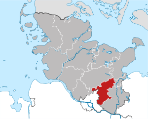
Штормарн
- район в Шлезвиг-Гольштейне, Германия
Hiking in Штормарн
Stormarn is a district in the federal state of Schleswig-Holstein, Germany, known for its beautiful landscapes, lush forests, and charming villages. Hiking in this area offers a variety of trails suitable for all levels of experience, catering to both casual walkers and avid trekkers. Here are some highlights and tips for hiking in Stormarn:...
- Страна:
- Код автомобильного номера: OD
- Координаты: 53° 45' 0" N, 10° 19' 48" E
- GPS треки (wikiloc): [Ссылка]
- Высота над уровнем моря: 34 м m
- Площадь: 766.33 кв.км
- Население: 236705
- Веб сайт: [Ссылка]

Куксхафен
Hiking in Куксхафен
Cuxhaven, located in Lower Saxony, Germany, offers a unique hiking experience with its combination of coastal landscapes, nature reserves, and historical sites. Here are some highlights of hiking in the Cuxhaven district:...
- Страна:
- Столица: Куксхафен
- Код автомобильного номера: CUX
- Координаты: 53° 40' 12" N, 8° 49' 48" E
- GPS треки (wikiloc): [Ссылка]
- Высота над уровнем моря: 5 м m
- Площадь: 2057.78 кв.км
- Население: 198670
- Веб сайт: [Ссылка]


Штаде
- район земли Нижняя Саксония, Германия
Hiking in Штаде
Stade, located in Lower Saxony, Germany, offers a range of hiking opportunities that allow you to explore its picturesque natural landscapes, historical sites, and charming small towns. Here are some highlights for hiking in the Stade district:...
- Страна:
- Код автомобильного номера: STD
- Координаты: 53° 34' 48" N, 9° 25' 12" E
- GPS треки (wikiloc): [Ссылка]
- Высота над уровнем моря: 1 м m
- Площадь: 1266.00 кв.км
- Население: 201638
- Веб сайт: [Ссылка]