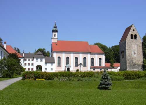
Вайльхайм (Weilheim in Oberbayern, Weilheim in Oberbayern)


- город в Баварии, Германия
 Hiking in Вайльхайм
Weilheim in Oberbayern is a charming town located in Bavaria, Germany, surrounded by beautiful landscapes that make it a fantastic destination for hiking enthusiasts. The region is characterized by its rolling hills, forests, and proximity to the Alps, offering a variety of trails suitable for different skill levels.
Hiking Highlights in Weilheim
-
Scenic Trails:
- There are numerous well-marked hiking trails around Weilheim that cater to both casual walkers and experienced hikers. The scenery often includes picturesque views of the Bavarian countryside, charming villages, and the distant Alps.
-
Tierisch Gut Trail:
- This specific trail is family-friendly and highlights the local flora and fauna, making it an educational experience as well.
-
Prettau Trail:
- A more challenging hike that offers stunning views over the surrounding mountains and valleys. It’s ideal for more experienced hikers looking for a workout and breathtaking vistas.
-
Lake Wörthsee and Ammersee:
- A bit further afield, but easily accessible, these lakes provide additional hiking opportunities with lake-side paths and beautiful nature.
-
Nature Reserves:
- The region is home to several nature reserves. Hiking through these areas offers a chance to observe various wildlife and native plants, as well as enjoy peaceful, uncrowded trails.
Tips for Hiking in Weilheim
-
Trail Maps: It's advisable to carry a hiking map or download a hiking app for real-time navigation.
-
Weather Preparedness: Bavaria can have unpredictable weather, so be prepared for changing conditions. Always check the forecast before setting out.
-
Gear: Wear appropriate footwear and pack essentials like water, snacks, and a first-aid kit. A hiking pole can be helpful on steeper trails.
-
Local Etiquette: Respect nature and other hikers; stick to marked paths and follow local guidelines regarding wildlife.
-
Time Your Hike: Some trails might take a few hours, so start early in the day to ensure you return before sunset.
Weilheim in Oberbayern makes an excellent base for exploring the natural beauty of Bavaria, and your time spent hiking here is sure to be rewarding. Enjoy your adventure!
- Страна:

- Почтовый код: 82362
- Телефонный код: 0881
- Код автомобильного номера: WM
- Координаты: 47° 50' 0" N, 11° 8' 0" E


- GPS треки (wikiloc): [Ссылка]
- Высота над уровнем моря: 563 м m
- Площадь: 55.44 кв.км
- Население: 22345
- Веб сайт: http://www.weilheim.de
- Википедия русская: wiki(ru)
- Википедия английская: wiki(en)
- Википедия национальная: wiki(de)
- Хранилище Wikidata: Wikidata: Q535674
- Катеория в википедии: [Ссылка]
- код Freebase: [/m/07wymz]
- код GeoNames: Альт: [2812515]
- код BNF: [16055624w]
- код VIAF: Альт: [167951284]
- ID отношения в OpenStreetMap: [936925]
- код GND: Альт: [4065098-4]
- идентификатор местоположения ArchINFORM: [5661]
- код LCNAF: Альт: [n89624801]
- место в MusicBrainz: [ed97bdc0-6326-447c-9fbe-9d4399dfc3d0]
- код темы Quora: [Weilheim-in-Oberbayern]
- код Historical Gazetteer: [object_300614]
- код места в Facebook: [104043582964769]
- Bavarikon ID: [ODB_A00001420]
- код NLI: [001026051]
- FAST ID: [1250916]
- идентификатор муниципалитетов в Германии: 09190157
Граничит с регионами:


Поллинг
- муниципалитет в Германии, Бавария
Hiking in Поллинг
Polling, located in the Weilheim-Schongau district of Bavaria, Germany, is surrounded by beautiful landscapes that make it a lovely destination for hiking enthusiasts. The area is characterized by rolling hills, lush forests, and picturesque views, making it ideal for various hiking activities....
- Страна:
- Почтовый код: 82398
- Телефонный код: 0881
- Код автомобильного номера: WM
- Координаты: 47° 48' 40" N, 11° 7' 51" E
- GPS треки (wikiloc): [Ссылка]
- Высота над уровнем моря: 567 м m
- Площадь: 29.2 кв.км
- Население: 2629
- Веб сайт: [Ссылка]


Виленбах
Hiking in Виленбах
Wielenbach is a picturesque municipality located in Bavaria, Germany, and it's surrounded by beautiful landscapes that make it a great destination for hiking enthusiasts. Here’s what you can expect when hiking in Wielenbach:...
- Страна:
- Почтовый код: 82407
- Телефонный код: 0881
- Код автомобильного номера: WM
- Координаты: 47° 52' 0" N, 11° 9' 0" E
- GPS треки (wikiloc): [Ссылка]
- Высота над уровнем моря: 547 м m
- Площадь: 33.01 кв.км
- Население: 2573
- Веб сайт: [Ссылка]


Эберфинг
Hiking in Эберфинг
Eberfing is a small municipality located in Bavaria, Germany, known for its picturesque landscapes and outdoor activities, including hiking. The region offers a variety of hiking trails that cater to different skill levels, making it suitable for both beginners and experienced hikers....
- Страна:
- Почтовый код: 82390
- Телефонный код: 08802
- Код автомобильного номера: WM
- Координаты: 47° 48' 0" N, 11° 12' 0" E
- GPS треки (wikiloc): [Ссылка]
- Высота над уровнем моря: 611 м m
- Площадь: 25.93 кв.км
- Население: 872
- Веб сайт: [Ссылка]


Зеесхаупт
- коммуна в Баварии, Германия
Hiking in Зеесхаупт
Seeshaupt is a beautiful village located on the southern edge of Lake Starnberg in Bavaria, Germany. It’s a fantastic destination for hiking enthusiasts, offering a variety of trails that showcase the stunning natural beauty of the area. Here are some key points to consider if you're planning a hiking trip in Seeshaupt:...
- Страна:
- Почтовый код: 82402
- Телефонный код: 08801
- Код автомобильного номера: WM
- Координаты: 47° 49' 28" N, 11° 18' 3" E
- GPS треки (wikiloc): [Ссылка]
- Высота над уровнем моря: 497 м m
- Площадь: 29.97 кв.км
- Население: 3108
- Веб сайт: [Ссылка]

Вессобрунн
Hiking in Вессобрунн
Wessobrunn is a picturesque village located in Bavaria, Germany, surrounded by beautiful landscapes and offers various hiking opportunities that cater to different skill levels. Here’s an overview of what to expect when hiking in the area:...
- Страна:
- Почтовый код: 82405
- Телефонный код: 08809
- Код автомобильного номера: WM
- Координаты: 47° 53' 0" N, 11° 2' 0" E
- GPS треки (wikiloc): [Ссылка]
- Высота над уровнем моря: 702 м m
- Площадь: 51.11 кв.км
- Население: 1761
- Веб сайт: [Ссылка]


Райстинг
Hiking in Райстинг
Raisting, located in Bavaria, Germany, offers beautiful hiking opportunities, particularly given its scenic landscapes and proximity to the Ammersee lake. Here are some key points to consider if you plan to hike in Raisting:...
- Страна:
- Почтовый код: 82399
- Телефонный код: 08807
- Код автомобильного номера: WM
- Координаты: 47° 55' 0" N, 11° 6' 0" E
- GPS треки (wikiloc): [Ссылка]
- Высота над уровнем моря: 553 м m
- Площадь: 21.98 кв.км
- Население: 1541
- Веб сайт: [Ссылка]