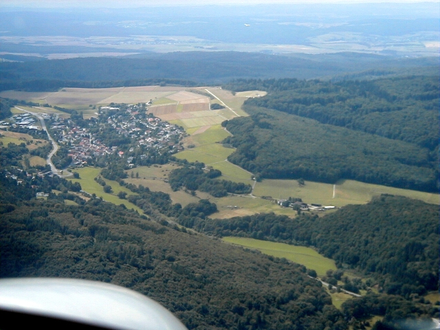
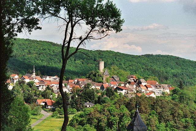
Вайльрод (Weilrod, Weilrod)

 Hiking in Вайльрод
Weilrod is a charming municipality located in the Taunus mountain range of Hesse, Germany. It offers a variety of hiking opportunities that cater to different fitness levels and interests. Here are some highlights for hiking in Weilrod:
Trails and Scenery
-
Diverse Terrain: Weilrod features forested areas, rolling hills, and picturesque landscapes, ideal for nature enthusiasts and photographers. The trails often offer stunning views of the surrounding Taunus hills.
-
Well-Marked Trails: The area has a network of well-marked hiking trails, including the renowned "Qualitätsweg," which follows the Hessen Trail (Hessenweg) and provides a rich hiking experience through natural beauty.
-
Historical Sites: Many trails take you past historical sites, such as old ruins and charming villages. Incorporating cultural exploration into your hike can enhance the experience.
-
Flora and Fauna: The region is rich in biodiversity, making it a great place for birdwatching and studying local plants.
Hiking Tips
- Seasonal Considerations: The best time for hiking in Weilrod typically spans from spring to early autumn. Winters can be cold with snow, which may restrict certain trails.
- Gear: Good hiking boots are essential due to variable terrain. Depending on the season, layered clothing will help you manage changing temperatures.
- Hydration and Snacks: Always carry sufficient water and snacks, especially on longer hikes. There are few eateries on the trails.
Safety and Regulations
- Trail Etiquette: Stay on marked paths to protect local wildlife and vegetation.
- Weather Awareness: Check the weather forecast and be prepared for sudden changes, common in mountainous regions.
- Group Hiking: If you're unfamiliar with the area, consider hiking with a group or using local guides for a safer experience.
Local Attractions
After your hike, you may want to explore local attractions in Weilrod, such as quaint cafes or shops, to enjoy regional cuisine or purchase local crafts.
Whether you're looking for a leisurely stroll or a challenging hike, Weilrod offers an inviting outdoor experience for all levels of hikers.
- Страна:

- Почтовый код: 61276
- Телефонный код: 06084; 06083
- Код автомобильного номера: HG
- Координаты: 50° 20' 44" N, 8° 22' 58" E


- GPS треки (wikiloc): [Ссылка]
- Высота над уровнем моря: 434 м m
- Площадь: 71.16 кв.км
- Население: 6422
- Веб сайт: http://www.weilrod.de
- Википедия русская: wiki(ru)
- Википедия английская: wiki(en)
- Википедия национальная: wiki(de)
- Хранилище Wikidata: Wikidata: Q573945
- Катеория в википедии: [Ссылка]
- Карты в википедии: [Ссылка]
- код Freebase: [/m/0f9gv_]
- код GeoNames: Альт: [3208136]
- код VIAF: Альт: [156003186]
- ID отношения в OpenStreetMap: [418383]
- код GND: Альт: [4065103-4]
- код LCNAF: Альт: [n85124430]
- код Historical Gazetteer: [WEIRODJO40EI]
- идентификатор муниципалитетов в Германии: 06434013
Включает регионы:


Emmershausen
Hiking in Emmershausen
Emmershausen is a charming village located in the picturesque region of Rhineland-Palatinate, Germany. Known for its beautiful natural scenery, it offers a great environment for hiking enthusiasts. Here are some highlights and tips for hiking in Emmershausen:...
- Страна:
- Почтовый код: 61276
- Телефонный код: 06083
- Координаты: 50° 21' 53" N, 8° 22' 37" E
- GPS треки (wikiloc): [Ссылка]
- Высота над уровнем моря: 244 м m
- Площадь: 6.52 кв.км
Finsternthal
Hiking in Finsternthal
Finsternthal is a lesser-known but beautiful hiking destination, situated in the heart of nature. It offers diverse landscapes and opportunities for outdoor activities, making it a great choice for hikers of all levels. Here are some aspects to consider if you plan to hike in Finsternthal:...
- Страна:
- Почтовый код: 61276
- Телефонный код: 06084
- Координаты: 50° 17' 37" N, 8° 24' 48" E
- GPS треки (wikiloc): [Ссылка]
- Высота над уровнем моря: 388 м m
- Площадь: 3.80 кв.км
Gemünden
Hiking in Gemünden
Gemünden (Taunus) is a charming town located within the Taunus mountain range in Germany. This region offers beautiful landscapes, scenic trails, and plenty of opportunities for outdoor activities, particularly hiking....
- Страна:
- Почтовый код: 61276
- Телефонный код: 06083
- Координаты: 50° 21' 32" N, 8° 24' 20" E
- GPS треки (wikiloc): [Ссылка]
- Высота над уровнем моря: 257 м m
- Площадь: 5.55 кв.км
Oberlauken
Hiking in Oberlauken
Oberlauken is a small village located in the stunning region of Switzerland, often characterized by its beautiful landscapes, scenic trails, and tranquil atmosphere. Hiking in and around Oberlauken offers a variety of paths for groups of all skill levels, from enthusiastic beginners to seasoned trekkers....
- Страна:
- Почтовый код: 61276
- Телефонный код: 06083
- Координаты: 50° 20' 3" N, 8° 25' 53" E
- GPS треки (wikiloc): [Ссылка]
- Высота над уровнем моря: 333 м m
- Площадь: 4.95 кв.км
Hasselbach
Hiking in Hasselbach
Hasselbach is a charming village located in the Taunus mountain range in Hesse, Germany, and it offers a fantastic experience for hikers. The region is characterized by its beautiful landscapes, dense forests, and numerous trails that cater to various skill levels. Here are some key points about hiking in Hasselbach (Taunus):...
- Страна:
- Почтовый код: 61276
- Телефонный код: 06083
- Координаты: 50° 20' 16" N, 8° 20' 43" E
- GPS треки (wikiloc): [Ссылка]
- Высота над уровнем моря: 386 м m
- Площадь: 9.04 кв.км
Mauloff
Hiking in Mauloff
Mauloff is not widely recognized as a hiking destination, and specific information may be limited. However, if you meant Mölln in Germany or another similarly named location, please confirm so I can provide accurate and relevant hiking information....
- Страна:
- Почтовый код: 61276
- Телефонный код: 06084
- Координаты: 50° 17' 2" N, 8° 23' 51" E
- GPS треки (wikiloc): [Ссылка]
- Высота над уровнем моря: 527 м m
- Площадь: 3.19 кв.км
Niederlauken
Hiking in Niederlauken
Niederlauken is a picturesque village located in Germany, surrounded by beautiful landscapes and a variety of outdoor opportunities. Hiking in Niederlauken offers a chance to explore scenic routes that showcase the region's natural beauty, including lush forests, gentle hills, and charming rural views....
- Страна:
- Почтовый код: 61276
- Телефонный код: 06083
- Координаты: 50° 20' 41" N, 8° 25' 58" E
- GPS треки (wikiloc): [Ссылка]
- Высота над уровнем моря: 295 м m
- Площадь: 7.67 кв.км
Rod an der Weil
Hiking in Rod an der Weil
Rod an der Weil is a charming village located in the Main-Taunus-Kreis district of Hesse, Germany. The surrounding region offers a variety of hiking opportunities suitable for different skill levels. Here are some general insights into hiking in and around Rod an der Weil:...
- Страна:
- Почтовый код: 61276
- Телефонный код: 06083
- Координаты: 50° 20' 37" N, 8° 22' 41" E
- GPS треки (wikiloc): [Ссылка]
- Высота над уровнем моря: 271 м m
- Площадь: 7.72 кв.км

Riedelbach
Hiking in Riedelbach
Riedelbach, located in Weilrod within the Hochtaunus district of Hesse, Germany, offers a scenic and tranquil setting for hiking enthusiasts. The area is characterized by its lush forests, rolling hills, and beautiful landscapes, making it an ideal destination for outdoor activities....
- Страна:
- Почтовый код: 61276
- Телефонный код: 06083
- Координаты: 50° 18' 5" N, 8° 23' 37" E
- GPS треки (wikiloc): [Ссылка]
- Высота над уровнем моря: 433 м m
- Площадь: 8.64 кв.км


Winden
Hiking in Winden
Winden, located in Weilrod, Germany, is surrounded by beautiful landscapes that make it an excellent destination for hiking enthusiasts. The area is part of the Hochtaunus Nature Park, which offers a variety of trails suited for different skill levels and preferences. Here are some key points about hiking in Winden:...
- Страна:
- Почтовый код: 61276
- Телефонный код: 06083
- Координаты: 50° 22' 57" N, 8° 23' 29" E
- GPS треки (wikiloc): [Ссылка]
- Высота над уровнем моря: 220 м m
- Площадь: 1.27 кв.км

Altweilnau
Hiking in Altweilnau
Altweilnau is a picturesque area nestled in the hills of Hesse, Germany, near the town of Bad Schwalbach. It offers a range of hiking opportunities suited for various skill levels. Here are some aspects to consider if you plan to hike in Altweilnau:...
- Страна:
- Почтовый код: 61276
- Телефонный код: 06083
- Координаты: 50° 18' 58" N, 8° 25' 9" E
- GPS треки (wikiloc): [Ссылка]
- Высота над уровнем моря: 381 м m
- Площадь: 4.89 кв.км
Cratzenbach
Hiking in Cratzenbach
Cratzenbach, which is often associated with various regions including Germany, offers a range of scenic hiking opportunities. When planning a hike in this area, it's important to consider the terrain, trail options, and local highlights....
- Страна:
- Почтовый код: 61276
- Телефонный код: 06083
- Координаты: 50° 19' 32" N, 8° 23' 5" E
- GPS треки (wikiloc): [Ссылка]
- Высота над уровнем моря: 385 м m
- Площадь: 4.5 кв.км


Neuweilnau
Hiking in Neuweilnau
Neuweilnau, located in the scenic region of Hesse, Germany, offers various hiking opportunities amid lush forests, rolling hills, and beautiful landscapes. Here are some key aspects to consider when hiking in Neuweilnau:...
- Страна:
- Почтовый код: 61276
- Телефонный код: 06083
- Координаты: 50° 19' 3" N, 8° 24' 28" E
- GPS треки (wikiloc): [Ссылка]
- Высота над уровнем моря: 347 м m
- Площадь: 3.44 кв.км