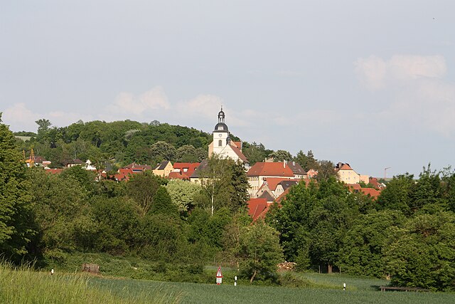
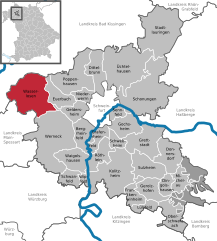
Вернек (Werneck, Werneck)

 Hiking in Вернек
Werneck is a picturesque town located in Bavaria, Germany, known for its scenic landscapes and outdoor activities, including hiking. While it might not be one of the most famous hiking destinations in Germany, there are several opportunities to enjoy nature and explore the surrounding areas. Here are some key points about hiking in and around Werneck:
Trails and Routes
-
Local Trails: There are various local trails that cater to different skill levels. Many routes are relatively easy, making them suitable for families and casual hikers.
-
Nature Reserves: The nearby nature reserves offer beautiful views and a chance to see local fauna and flora. Look for trails that lead through forests, near rivers, or around lakes.
-
Regional Hiking Paths: Werneck is well-connected to larger hiking networks in the region, allowing hikers to explore longer distances. You may find routes that connect to the Franconian Switzerland or the Rhön region, known for their rugged terrain and unique geological features.
Preparation and Tips
-
Maps and Guides: It's advisable to carry a detailed map or use a hiking app to navigate the trails. They will help you stay on track and identify points of interest along the way.
-
Weather Considerations: Check the weather before setting out, as conditions can change rapidly. Appropriate clothing and gear are essential.
-
Safety First: Always inform someone about your hiking plans, especially if you’re heading out on less-traveled paths. Carry a first-aid kit, sufficient water, and snacks.
-
Wildlife Awareness: Be mindful of local wildlife, and follow guidelines to minimize your impact on the environment.
Attractions
-
Historic Sightseeing: While hiking, you might also explore historical sites in Werneck, such as its castle and church, which add a cultural dimension to your outdoor activities.
-
Cafés and Rest Stops: After a day of hiking, consider stopping at local cafés or restaurants to enjoy Bavarian specialties.
Conclusion
Hiking in and around Werneck can be a delightful experience, providing both tranquil nature and a chance to engage with Bavarian culture. Whether you’re looking for a leisurely stroll or a more challenging hike, the area has something to offer. Always be prepared, respect nature, and enjoy the beautiful surroundings!
- Страна:

- Почтовый код: 97440
- Телефонный код: 09722
- Код автомобильного номера: SW
- Координаты: 49° 59' 0" N, 10° 6' 0" E


- GPS треки (wikiloc): [Ссылка]
- Высота над уровнем моря: 222 м m
- Площадь: 73.56 кв.км
- Население: 10177
- Веб сайт: https://www.werneck.de/
- Википедия русская: wiki(ru)
- Википедия английская: wiki(en)
- Википедия национальная: wiki(de)
- Хранилище Wikidata: Wikidata: Q526691
- Катеория в википедии: [Ссылка]
- код Freebase: [/m/0dz66n]
- код GeoNames: Альт: [2810832]
- код BNF: [11956590h]
- код VIAF: Альт: [132565406]
- ID отношения в OpenStreetMap: [318733]
- код GND: Альт: [4065626-3]
- идентификатор местоположения ArchINFORM: [280]
- код LCNAF: Альт: [n83200990]
- место в MusicBrainz: [21096dd4-3cc9-43a3-b684-f19994a7eb4a]
- Bavarikon ID: [ODB_A00000490]
- идентификатор муниципалитетов в Германии: 09678193
Граничит с регионами:
Арнштайн
Hiking in Арнштайн
Arnstein is a beautiful area for hiking, set amidst picturesque natural landscapes. It is located in Bavaria, Germany, and is characterized by its charming villages, serene countryside, and rolling hills. Here are some highlights and tips for hiking in Arnstein:...
- Страна:
- Почтовый код: 97450
- Телефонный код: 09363
- Код автомобильного номера: MSP
- Координаты: 49° 58' 0" N, 9° 59' 0" E
- GPS треки (wikiloc): [Ссылка]
- Высота над уровнем моря: 228 м m
- Площадь: 112.12 кв.км
- Население: 7640
- Веб сайт: [Ссылка]

Вассерлозен
Hiking in Вассерлозен
Wasserlosen is a small municipality in Bavaria, Germany, known for its peaceful landscapes and rural charm. While it may not be a bustling hiking destination like some larger national parks, it offers several opportunities for hiking and enjoying nature....
- Страна:
- Почтовый код: 97535
- Телефонный код: 09726
- Код автомобильного номера: SW
- Координаты: 50° 5' 41" N, 10° 1' 49" E
- GPS треки (wikiloc): [Ссылка]
- Высота над уровнем моря: 340 м m
- Площадь: 51.32 кв.км
- Население: 3170
- Веб сайт: [Ссылка]