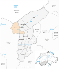
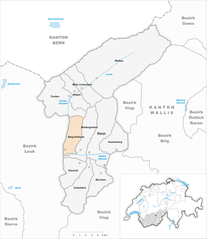
Westlich Raron District (Bezirk Westlich Raron)

 Hiking in Westlich Raron District
Westlich Raron is a beautiful area located in the Swiss Alps, specifically in the Valais region of Switzerland. It's known for its stunning landscapes, diverse trails, and the picturesque views of the surrounding mountains. Here are some key points to consider if you're planning to hike in this region:
Trails and Difficulty Levels
- Varied Terrain: The hiking trails around Westlich Raron range from easy to challenging, making it suitable for hikers of all levels.
- Local Recommendations: Popular trails often include routes that take you to viewpoints like the Raron Tunnels or towards the valley floor, as well as higher elevation paths that offer breathtaking panoramas.
- Marked Trails: The Swiss hiking network is well-marked, so it's easy to find your way. Look for signs indicating the trail numbers and difficulty levels.
Scenic Views
- Mountain Views: Hikes in this area provide stunning vistas of Swiss peaks, including the iconic Matterhorn and the surrounding landscapes.
- Wildlife and Flora: Depending on the season, you might encounter diverse alpine flora and fauna. Spring and summer are particularly vibrant times for wildflowers.
Accessibility
- Getting There: The area is accessible by public transport, making it easy to reach trailheads. Check local schedules for trains and buses that connect to Raron.
- Accommodations: There are various options for staying in the region, from hotels to mountain lodges and campsites, depending on your preference for comfort or adventure.
Preparation Tips
- Weather Check: Always check the weather forecast before setting out, as conditions can change rapidly in the mountains.
- Pack Essentials: Bring sufficient water, snacks, a map, a first aid kit, and appropriate clothing for varying weather.
- Safety First: If you're unsure about your skills or the trail's difficulty, consider going with a guide or joining a group organization.
Local Culture
- Swiss Hospitality: Enjoy the local cuisine in nearby towns, and immerse yourself in the charming Swiss culture.
- Historical Sites: Explore local historical sites, such as the church in Raron or remnants of ancient Roman routes, which provide insight into the region's rich history.
Whether you're seeking a leisurely walk or an adventurous trek, Westlich Raron offers ample opportunities for a memorable hiking experience. Always remember to practice Leave No Trace principles to preserve the beauty of the area for future visitors!
- Страна:

- Столица: Raron
- Код автомобильного номера: VS
- Координаты: 46° 18' 0" N, 8° 48' 0" E


- GPS треки (wikiloc): [Ссылка]
- Площадь: 270.87 кв.км
- Википедия английская: wiki(en)
- Википедия национальная: wiki(de)
- Хранилище Wikidata: Wikidata: Q660861
- Катеория в википедии: [Ссылка]
- код Freebase: [/m/05zzj8s]
- код GeoNames: Альт: [2658013]
- идентификатор местоположения ArchINFORM: [45092]
- идентификатор HDS: [8402]
Включает регионы:


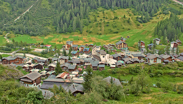
Wiler
Hiking in Wiler
Wiler, located in the beautiful Valais region of Switzerland, offers a variety of stunning hiking opportunities. Nestled in the Alps, it provides picturesque views, lush green landscapes, and interesting trails that cater to various skill levels. Here are some highlights and tips regarding hiking in Wiler:...
- Страна:
- Почтовый код: 3918
- Телефонный код: 027
- Код автомобильного номера: VS
- Координаты: 46° 23' 0" N, 7° 46' 0" E
- GPS треки (wikiloc): [Ссылка]
- Высота над уровнем моря: 1424 м m
- Площадь: 14.68 кв.км
- Население: 571
- Веб сайт: [Ссылка]

Blatten
Hiking in Blatten
Blatten, located in the Lötschen Valley of Switzerland, is a fantastic destination for hiking enthusiasts. This picturesque village is part of the municipality of Naters in the canton of Valais, offering stunning panoramic views of the surrounding mountains....
- Страна:
- Почтовый код: 3919
- Телефонный код: 027
- Код автомобильного номера: VS
- Координаты: 46° 25' 0" N, 7° 49' 0" E
- GPS треки (wikiloc): [Ссылка]
- Высота над уровнем моря: 1542 м m
- Площадь: 90.63 кв.км
- Население: 294
- Веб сайт: [Ссылка]


Kippel
Hiking in Kippel
Kippel, located in the picturesque region of the Valais in Switzerland, offers a variety of hiking opportunities for outdoor enthusiasts. The area is known for its stunning alpine scenery, lush meadows, and breathtaking views of the surrounding mountains....
- Страна:
- Почтовый код: 3917
- Телефонный код: 027
- Код автомобильного номера: VS
- Координаты: 46° 23' 0" N, 7° 46' 0" E
- GPS треки (wikiloc): [Ссылка]
- Высота над уровнем моря: 1376 м m
- Площадь: 11.66 кв.км
- Население: 331
- Веб сайт: [Ссылка]


Ausserberg
Hiking in Ausserberg
Ausserberg, located in the heart of the Swiss Alps in the canton of Valais, is a charming destination for hiking enthusiasts. Here are some key points to consider if you're planning to hike in this beautiful area:...
- Страна:
- Почтовый код: 3938
- Телефонный код: 027
- Код автомобильного номера: VS
- Координаты: 46° 19' 0" N, 7° 51' 0" E
- GPS треки (wikiloc): [Ссылка]
- Высота над уровнем моря: 1008 м m
- Площадь: 10.08 кв.км
- Население: 623
- Веб сайт: [Ссылка]

Ferden
Hiking in Ferden
Ferden is a small village located in the canton of Valais in Switzerland, known for its stunning landscapes and access to beautiful hiking trails. Here are some highlights for hiking in the Ferden area:...
- Страна:
- Почтовый код: 3916
- Телефонный код: 027
- Код автомобильного номера: VS
- Координаты: 46° 22' 0" N, 7° 45' 0" E
- GPS треки (wikiloc): [Ссылка]
- Высота над уровнем моря: 1384 м m
- Площадь: 27.89 кв.км
- Население: 251
- Веб сайт: [Ссылка]

Unterbäch
Hiking in Unterbäch
Unterbäch is a charming village located in the Valais region of Switzerland, surrounded by stunning alpine scenery. It's an excellent destination for hikers, offering a variety of trails that cater to different skill levels. Here are some highlights and tips for hiking in Unterbäch:...
- Страна:
- Почтовый код: 3944
- Телефонный код: 027
- Код автомобильного номера: VS
- Координаты: 46° 15' 13" N, 7° 46' 39" E
- GPS треки (wikiloc): [Ссылка]
- Высота над уровнем моря: 2016 м m
- Площадь: 22.0 кв.км
- Население: 421
- Веб сайт: [Ссылка]


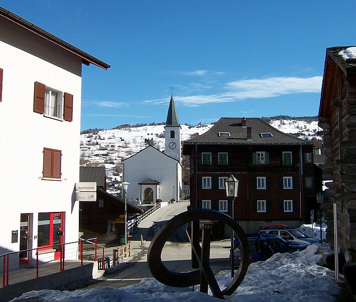
Raron
Hiking in Raron
Raron is a beautiful village located in the Valais region of Switzerland, renowned for its impressive scenery and excellent hiking opportunities. Nestled in the Rhone Valley, Raron offers a variety of trails that cater to different skill levels, from easy walks to more challenging hikes. Here are some highlights about hiking in Raron:...
- Страна:
- Почтовый код: 3942
- Телефонный код: 027
- Код автомобильного номера: VS
- Координаты: 46° 18' 36" N, 7° 48' 0" E
- GPS треки (wikiloc): [Ссылка]
- Высота над уровнем моря: 644 м m
- Площадь: 30.26 кв.км
- Население: 1930
- Веб сайт: [Ссылка]


Niedergesteln
Hiking in Niedergesteln
Niedergesteln is a charming village located in the Valais region of Switzerland, surrounded by stunning mountain scenery, making it an excellent destination for hiking enthusiasts. Here are some highlights and tips for hiking in Niedergesteln:...
- Страна:
- Почтовый код: 3942
- Телефонный код: 027
- Код автомобильного номера: VS
- Координаты: 46° 19' 0" N, 7° 46' 0" E
- GPS треки (wikiloc): [Ссылка]
- Высота над уровнем моря: 639 м m
- Площадь: 17.46 кв.км
- Население: 703
- Веб сайт: [Ссылка]


Eischoll
Hiking in Eischoll
Eischoll, situated in the Valais region of Switzerland, is a small village known for its stunning natural landscapes and outdoor activities, including hiking. The area is surrounded by impressive mountains, making it a beautiful spot for both casual and experienced hikers....
- Страна:
- Почтовый код: 3943
- Телефонный код: 027
- Код автомобильного номера: VS
- Координаты: 46° 16' 0" N, 7° 46' 0" E
- GPS треки (wikiloc): [Ссылка]
- Высота над уровнем моря: 1239 м m
- Площадь: 13.75 кв.км
- Население: 438
- Веб сайт: [Ссылка]

Steg-Hohtenn
Hiking in Steg-Hohtenn
Steg-Hohtenn is a beautiful region in the canton of Valais, Switzerland, known for its stunning landscapes and diverse hiking trails. Nestled in the valleys of the Swiss Alps, it offers options for both beginner hikers and experienced trekkers....
- Страна:
- Почтовый код: 3940
- Телефонный код: 027
- Код автомобильного номера: VS
- Координаты: 46° 17' 0" N, 7° 47' 0" E
- GPS треки (wikiloc): [Ссылка]
- Высота над уровнем моря: 640 м m
- Площадь: 14.21 кв.км
- Население: 1569
- Веб сайт: [Ссылка]
Bürchen
Hiking in Bürchen
Bürchen is a beautiful hiking destination located in the Swiss Alps, specifically in the canton of Valais. Known for its stunning scenery and diverse hiking trails, Bürchen offers outdoor enthusiasts a chance to explore the natural beauty of Switzerland....
- Страна:
- Почтовый код: 3935
- Телефонный код: 027
- Код автомобильного номера: VS
- Координаты: 46° 16' 11" N, 7° 49' 5" E
- GPS треки (wikiloc): [Ссылка]
- Высота над уровнем моря: 1563 м m
- Площадь: 13.41 кв.км
- Население: 715
- Веб сайт: [Ссылка]
Граничит с регионами:


Brig District
Hiking in Brig District
The Brig District, located in the Valais canton of Switzerland, is a picturesque region known for its stunning landscapes, rich history, and a variety of hiking opportunities. Here’s what you need to know about hiking in this beautiful area:...
- Страна:
- Столица: Бриг
- Координаты: 46° 18' 42" N, 7° 59' 6" E
- GPS треки (wikiloc): [Ссылка]
- Высота над уровнем моря: 1478 м m
- Площадь: 434.5 кв.км


Висп
Hiking in Висп
The Visp District, located in the Valais canton of Switzerland, is an excellent destination for hiking enthusiasts. Surrounded by stunning Alpine scenery, it offers a variety of trails suitable for different skill levels, from beginners to experienced hikers. Here are some highlights and key points regarding hiking in the Visp District:...
- Страна:
- Столица: Фисп
- Код автомобильного номера: VS
- Координаты: 46° 17' 0" N, 7° 52' 0" E
- GPS треки (wikiloc): [Ссылка]
- Высота над уровнем моря: 2758 м m
- Площадь: 863.8 кв.км

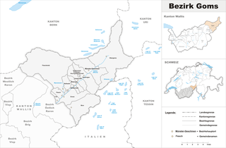
Goms District
Hiking in Goms District
Goms District, located in the Valais region of Switzerland, is a stunning destination for hiking enthusiasts. Known for its picturesque landscapes, charming villages, and rich cultural heritage, Goms offers a variety of hiking trails suited for different skill levels....
- Страна:
- Столица: Münster-Geschinen
- Код автомобильного номера: VS
- Координаты: 46° 27' 0" N, 8° 18' 0" E
- GPS треки (wikiloc): [Ссылка]
- Высота над уровнем моря: 1407 м m
- Площадь: 588.3 кв.км


Лойк
Hiking in Лойк
The Leuk District, located in the Valais canton of Switzerland, is a stunning hiking destination known for its diverse landscapes, charming villages, and a variety of trails suitable for all skill levels. Here are some key highlights to consider when planning a hiking trip in this region:...
- Страна:
- Столица: Leuk
- Код автомобильного номера: VS
- Координаты: 46° 19' 5" N, 7° 38' 4" E
- GPS треки (wikiloc): [Ссылка]
- Высота над уровнем моря: 957 м m
- Площадь: 335.9 кв.км