Вунзидель-Фихтель (Wunsiedel, Landkreis Wunsiedel i. Fichtelgebirge)

- район Баварии
 Hiking in Вунзидель-Фихтель
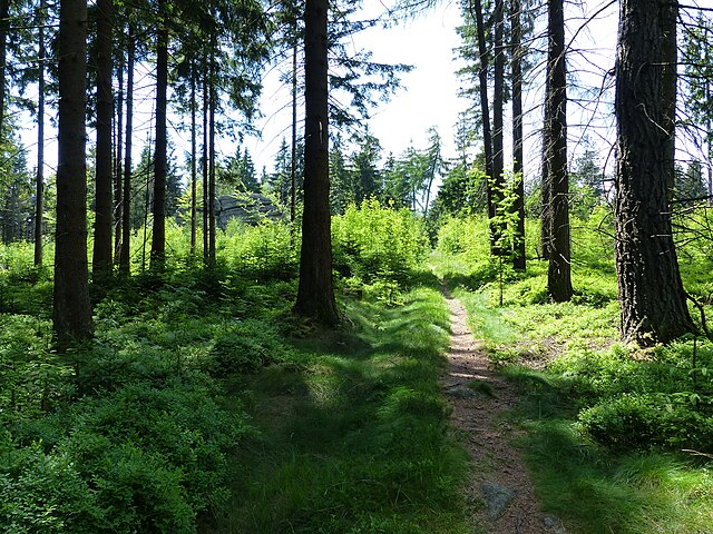
Wunsiedel is a picturesque district located in the Upper Franconia region of Bavaria, Germany. It's renowned for its beautiful landscapes, rich history, and a variety of hiking trails suitable for different skill levels. Here are some highlights of hiking in Wunsiedel:
Trails and Routes
-
Fichtelgebirge Nature Park: One of the main attractions for hikers, the Fichtelgebirge offers numerous trails that wind through stunning natural scenery, including forests, rocky outcrops, and panoramic views. The area has well-marked paths catering to various difficulty levels.
-
Golden Road (Der Goldene Weg): This historical trail connects several villages in the region and offers insights into the local culture and history. It's a great way to experience the local heritage while enjoying the beautiful Bavarian countryside.
-
Hiking to the Sächsische Schweiz: While a bit farther, this area is often included in hiking trips from Wunsiedel for its incredible rock formations and stunning vistas.
-
Circular Trails: There are many circular hiking routes around Wunsiedel, allowing you to explore the area's diverse wildlife and flora. The routes often include stops at viewpoints, historical sites, and interesting geological formations.
Points of Interest
- Luisenburg Rock Theatre: This open-air theater set among dramatic rock formations is a unique cultural site. Hikers might enjoy combining their trek with a visit to a performance.
- Fichtel Mountain: The highest peak in the region, it offers challenging hikes with rewarding views.
- Local Flora and Fauna: Wunsiedel’s trails are rich in biodiversity. Keep an eye out for various plant species, birds, and other wildlife.
Preparing for Your Hike
- Weather: The weather can change quickly in the Fichtelgebirge. Make sure to check forecasts and come prepared with appropriate clothing and gear.
- Maps and Navigation: Trails are generally well-marked, but carrying a detailed map or using a navigation app can help avoid getting lost.
- Safety Precautions: Inform someone of your hiking plans and expected return time, especially if you’re venturing into less traveled areas.
Best Seasons to Hike
- Spring: Enjoy vibrant wildflowers and pleasant temperatures.
- Summer: Ideal for long hikes, though it can get warm; ensure you stay hydrated.
- Autumn: Experience stunning fall foliage, making for a picturesque hike.
- Winter: Some trails are suitable for winter hiking or snowshoeing.
Wunsiedel and its surroundings offer a rich hiking experience for both novice and experienced hikers alike. Enjoy the natural beauty and don’t forget to take your camera to capture the stunning views!
- Страна:

- Код автомобильного номера: SEL; REH; MAK; WUN
- Координаты: 50° 5' 24" N, 12° 2' 24" E


- GPS треки (wikiloc): [Ссылка]
- Высота над уровнем моря: 558 м m
- Площадь: 606.40 кв.км
- Население: 87941
- Веб сайт: http://www.landkreis-wunsiedel.de/
- Википедия русская: wiki(ru)
- Википедия английская: wiki(en)
- Википедия национальная: wiki(de)
- Хранилище Wikidata: Wikidata: Q10432
- Катеория в википедии: [Ссылка]
- код Freebase: [/m/02hm2n]
- код GeoNames: Альт: [3220853]
- код VIAF: Альт: [248476159]
- ID отношения в OpenStreetMap: [62491]
- код GND: Альт: [4067078-8]
- идентификатор местоположения ArchINFORM: [2674]
- код LCNAF: Альт: [n82157864]
- код TGN: [7077099]
- код Historical Gazetteer: [adm_139479]
- Bavarikon ID: [ODB_A00002142]
- код NUTS: [DE24D]
- код района Германии: 09479
Включает регионы:


Kaiserhammer Forst-Ost
Hiking in Kaiserhammer Forst-Ost
Kaiserhammer Forst-Ost is a beautiful area for hiking, located in the region of Germany, specifically in the state of Bayern (Bavaria). Here are some things to know about hiking there:...
- Страна:
- Координаты: 50° 6' 0" N, 12° 8' 0" E
- GPS треки (wikiloc): [Ссылка]
Martinlamitzer Forst-Süd
Hiking in Martinlamitzer Forst-Süd
Martinlamitzer Forst-Süd is a lovely area located in Bavaria, Germany, and is known for its beautiful landscapes and diverse hiking opportunities. Here’s what you need to know about hiking in this region:...
- Страна:
- Координаты: 50° 10' 0" N, 12° 1' 0" E
- GPS треки (wikiloc): [Ссылка]


Meierhöfer Seite
Hiking in Meierhöfer Seite
Meierhöfer Seite, located in the beautiful region of Bavaria, Germany, is an excellent destination for hiking enthusiasts. This area is characterized by its scenic landscapes, including lush forests, rolling hills, and picturesque views of the surrounding countryside....
- Страна:
- Координаты: 50° 4' 0" N, 11° 53' 0" E
- GPS треки (wikiloc): [Ссылка]
Neubauer Forst-Süd
Hiking in Neubauer Forst-Süd
Neubauer Forst-Süd is a forested area in Germany that offers a variety of trails suitable for hiking and nature enthusiasts. While specific information about all the trails may not be widely published, here are some general highlights that can be expected in such a forested area:...
- Страна:
- Координаты: 50° 1' 0" N, 11° 52' 0" E
- GPS треки (wikiloc): [Ссылка]


Хоэнберг-на-Эгере
Hiking in Хоэнберг-на-Эгере
Hohenberg an der Eger, located in Bavaria, Germany, is a charming town that offers a variety of hiking opportunities. The region is characterized by beautiful landscapes, rolling hills, and forests, making it an excellent destination for outdoor enthusiasts. Here are some highlights and tips for hiking in and around Hohenberg an der Eger:...
- Страна:
- Почтовый код: 95691
- Телефонный код: 09233
- Код автомобильного номера: WUN
- Координаты: 50° 5' 42" N, 12° 13' 12" E
- GPS треки (wikiloc): [Ссылка]
- Высота над уровнем моря: 513 м m
- Площадь: 8.2 кв.км
- Население: 1452
- Веб сайт: [Ссылка]


Арцберг
Hiking in Арцберг
Arzberg, located in the scenic region of Bavaria, Germany, is a great destination for hiking enthusiasts. The area is characterized by its rolling hills, lush forests, and charming landscapes that provide a mix of easy to moderate hiking trails suitable for various skill levels....
- Страна:
- Почтовый код: 95659
- Телефонный код: 09233
- Код автомобильного номера: SEL; REH; MAK; WUN
- Координаты: 50° 4' 0" N, 12° 11' 0" E
- GPS треки (wikiloc): [Ссылка]
- Высота над уровнем моря: 481 м m
- Площадь: 43.22 кв.км
- Население: 5192
- Веб сайт: [Ссылка]


Трёстау
Hiking in Трёстау
Tröstau is a picturesque village located in Bavaria, Germany, surrounded by beautiful landscapes that are perfect for hiking enthusiasts. The region is characterized by its rolling hills, scenic forests, and charming rural settings, providing a variety of trails for hikers of all skill levels....
- Страна:
- Почтовый код: 95709
- Телефонный код: 09232
- Код автомобильного номера: WUN
- Координаты: 50° 1' 0" N, 11° 57' 0" E
- GPS треки (wikiloc): [Ссылка]
- Высота над уровнем моря: 550 м m
- Площадь: 19.28 кв.км
- Население: 2452
- Веб сайт: [Ссылка]


Ширндинг
Hiking in Ширндинг
Schirnding is a quaint town located in the Bavarian region of Germany, near the border with the Czech Republic. It is surrounded by beautiful landscapes, making it an excellent location for hiking enthusiasts. Here’s what you should know about hiking in Schirnding:...
- Страна:
- Почтовый код: 95706
- Телефонный код: 09233
- Код автомобильного номера: WUN
- Координаты: 50° 4' 0" N, 12° 13' 0" E
- GPS треки (wikiloc): [Ссылка]
- Высота над уровнем моря: 459 м m
- Площадь: 16.5 кв.км
- Население: 1812
- Веб сайт: [Ссылка]


Нагель
Hiking in Нагель
Hiking in Nagel, located in the Fichtelgebirge mountain range in Bavaria, Germany, offers a wonderful blend of natural beauty, diverse landscapes, and well-maintained trails. This region is known for its granite rock formations, dense forests, and scenic views....
- Страна:
- Почтовый код: 95697
- Телефонный код: 09236
- Код автомобильного номера: WUN
- Координаты: 49° 59' 0" N, 11° 55' 0" E
- GPS треки (wikiloc): [Ссылка]
- Высота над уровнем моря: 580 м m
- Площадь: 7.79 кв.км
- Население: 1693
- Веб сайт: [Ссылка]


Вунзидель
- населённый пункт в Германии
Hiking in Вунзидель
Wunsiedel, located in Bavaria, Germany, is a charming town that offers a variety of hiking opportunities, especially in the surrounding Fichtel Mountains. Here are some highlights and tips for hiking in and around Wunsiedel:...
- Страна:
- Почтовый код: 95632
- Телефонный код: 09232
- Код автомобильного номера: WUN
- Координаты: 50° 1' 0" N, 12° 1' 0" E
- GPS треки (wikiloc): [Ссылка]
- Высота над уровнем моря: 525 м m
- Площадь: 54.91 кв.км
- Население: 9172
- Веб сайт: [Ссылка]


Шёнвальд
- город в Германии, в земле Бавария
Hiking in Шёнвальд
Schönwald, located in the Bavarian Forest in Germany, is a great destination for hiking enthusiasts. This charming village offers a variety of trails that cater to all skill levels, making it a popular spot for both locals and tourists. Here are some highlights of hiking in Schönwald:...
- Страна:
- Почтовый код: 95173
- Телефонный код: 09287
- Код автомобильного номера: WUN
- Координаты: 50° 12' 0" N, 12° 5' 0" E
- GPS треки (wikiloc): [Ссылка]
- Высота над уровнем моря: 600 м m
- Площадь: 19.2 кв.км
- Население: 3195
- Веб сайт: [Ссылка]


Зельб
Hiking in Зельб
Selb, located in Bavaria, Germany, is a charming town known for its beautiful landscapes and proximity to hiking opportunities. While the town itself is modest in size, it serves as a great starting point for exploring the surrounding natural areas, particularly in the Fichtelgebirge region....
- Страна:
- Почтовый код: 95100
- Телефонный код: 09287
- Координаты: 50° 10' 14" N, 12° 7' 50" E
- GPS треки (wikiloc): [Ссылка]
- Высота над уровнем моря: 546 м m
- Площадь: 62.37 кв.км
- Население: 14928
- Веб сайт: [Ссылка]


Тирсхайм
Hiking in Тирсхайм
Thiersheim, located in Bavaria, Germany, is a charming area that offers a variety of hiking opportunities for outdoor enthusiasts. The region is characterized by its picturesque landscapes, rolling hills, and lush forests, making it an ideal destination for nature lovers....
- Страна:
- Почтовый код: 95707
- Телефонный код: 09233
- Код автомобильного номера: WUN
- Координаты: 50° 4' 0" N, 12° 7' 0" E
- GPS треки (wikiloc): [Ссылка]
- Высота над уровнем моря: 551 м m
- Площадь: 23.7 кв.км
- Население: 2203
- Веб сайт: [Ссылка]

Марктлёйтен
Hiking in Марктлёйтен
Marktleuthen is a charming town located in Bavaria, Germany, and is surrounded by beautiful natural landscapes, making it a great destination for hiking enthusiasts. Here are some highlights of hiking in and around Marktleuthen:...
- Страна:
- Почтовый код: 95168
- Телефонный код: 09285
- Код автомобильного номера: WUN
- Координаты: 50° 7' 0" N, 12° 0' 0" E
- GPS треки (wikiloc): [Ссылка]
- Высота над уровнем моря: 529 м m
- Площадь: 25.5 кв.км
- Население: 3942
- Веб сайт: [Ссылка]


Кирхенламиц
Hiking in Кирхенламиц
Kirchenlamitz is a charming area in the Upper Franconia region of Bavaria, Germany, and offers a range of hiking opportunities for outdoor enthusiasts. Here are some highlights of hiking in and around Kirchenlamitz:...
- Страна:
- Почтовый код: 95158
- Телефонный код: 09285
- Код автомобильного номера: WUN
- Координаты: 50° 9' 0" N, 11° 57' 0" E
- GPS треки (wikiloc): [Ссылка]
- Высота над уровнем моря: 591 м m
- Площадь: 48.5 кв.км
- Население: 3313
- Веб сайт: [Ссылка]

Марктредвиц
Hiking in Марктредвиц
Marktredwitz is a picturesque town located in Bavaria, Germany, and it is surrounded by beautiful natural landscapes, making it a fantastic destination for hiking enthusiasts. Here's what you should know about hiking in and around Marktredwitz:...
- Страна:
- Почтовый код: 95615
- Телефонный код: 09231
- Координаты: 50° 0' 0" N, 12° 4' 0" E
- GPS треки (wikiloc): [Ссылка]
- Высота над уровнем моря: 529 м m
- Площадь: 49.5 кв.км
- Население: 17130
- Веб сайт: [Ссылка]

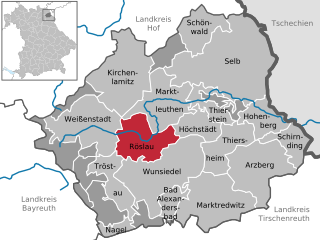
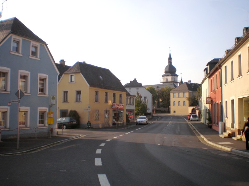
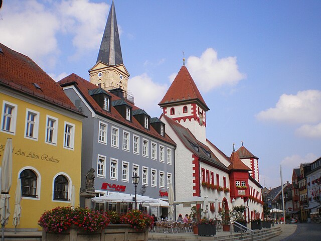
Рёслау
Hiking in Рёслау
Röslau is a picturesque village located in the Upper Franconia region of Germany, not far from the border with the Czech Republic. This area is known for its beautiful landscapes, including rolling hills, forests, and scenic trails, making it an excellent spot for hiking enthusiasts....
- Страна:
- Почтовый код: 95195
- Телефонный код: 09238
- Код автомобильного номера: WUN
- Координаты: 50° 4' 0" N, 11° 58' 0" E
- GPS треки (wikiloc): [Ссылка]
- Высота над уровнем моря: 571 м m
- Площадь: 29.8 кв.км
- Население: 2764
- Веб сайт: [Ссылка]


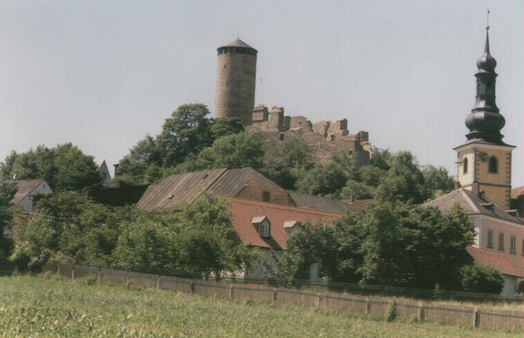
Бад-Александерсбад
Hiking in Бад-Александерсбад
Bad Alexandersbad is a beautiful spa town located in the Fichtelgebirge region of Bavaria, Germany. It offers a variety of hiking options suitable for all experience levels, with scenic trails that highlight the area's natural beauty, including dense forests, rolling hills, and stunning viewpoints....
- Страна:
- Почтовый код: 95680
- Телефонный код: 09232
- Код автомобильного номера: WUN
- Координаты: 50° 1' 0" N, 12° 1' 0" E
- GPS треки (wikiloc): [Ссылка]
- Высота над уровнем моря: 580 м m
- Площадь: 8.9 кв.км
- Население: 976
- Веб сайт: [Ссылка]


Вайсенштадт
Hiking in Вайсенштадт
Weißenstadt is a charming town located in the Franconian region of Bavaria, Germany. It is surrounded by beautiful natural landscapes, making it an excellent destination for hiking enthusiasts. Here are some key points to consider about hiking in and around Weißenstadt:...
- Страна:
- Почтовый код: 95163
- Телефонный код: 09253
- Код автомобильного номера: WUN
- Координаты: 50° 6' 3" N, 11° 53' 5" E
- GPS треки (wikiloc): [Ссылка]
- Высота над уровнем моря: 630 м m
- Площадь: 42.23 кв.км
- Население: 3846
- Веб сайт: [Ссылка]

Тирштайн
Hiking in Тирштайн
Thierstein, located in Bavaria, Germany, is a charming destination for hikers looking to explore the scenic beauty of the region. Nestled in the rolling hills and lush landscapes of Bavaria, Thierstein offers a variety of trails suited for different skill levels, from beginners to more experienced hikers....
- Страна:
- Почтовый код: 95199
- Телефонный код: 09235
- Код автомобильного номера: WUN
- Координаты: 50° 6' 0" N, 12° 5' 0" E
- GPS треки (wikiloc): [Ссылка]
- Высота над уровнем моря: 600 м m
- Площадь: 12.93 кв.км
- Население: 1232
- Веб сайт: [Ссылка]
Хёхштедт
Hiking in Хёхштедт
Höchstädt im Fichtelgebirge is a great destination for hiking enthusiasts. This charming village is situated in the Fichtel Mountains, offering a range of scenic trails that vary in difficulty and length. The region is known for its picturesque landscapes, lush forests, and unique granite rock formations....
- Страна:
- Почтовый код: 95186
- Телефонный код: 09235
- Код автомобильного номера: WUN
- Координаты: 50° 6' 0" N, 12° 5' 0" E
- GPS треки (wikiloc): [Ссылка]
- Высота над уровнем моря: 565 м m
- Площадь: 14.95 кв.км
- Население: 1107
- Веб сайт: [Ссылка]


Tröstauer Forst-Ost
Hiking in Tröstauer Forst-Ost
Tröstauer Forst-Ost is a lovely hiking destination located in Germany's Bavarian region, known for its picturesque landscapes, diverse flora and fauna, and peaceful atmosphere. Here are some key points to consider if you’re planning a hiking trip to Tröstauer Forst-Ost:...
- Страна:
- Координаты: 49° 59' 0" N, 11° 58' 0" E
- GPS треки (wikiloc): [Ссылка]


Tröstauer Forst-West
Hiking in Tröstauer Forst-West
Tröstauer Forst-West is a beautiful forest area located in Germany, known for its serene landscapes and diverse nature. It offers various hiking opportunities for outdoor enthusiasts, from easy walks to more challenging trails....
- Страна:
- Координаты: 50° 0' 0" N, 11° 55' 0" E
- GPS треки (wikiloc): [Ссылка]
Vordorfer Forst
Hiking in Vordorfer Forst
Vordorfer Forst is a beautiful forested area located in Germany, which offers a range of hiking opportunities for outdoor enthusiasts. Here are some highlights and tips for hiking in Vordorfer Forst:...
- Страна:
- Координаты: 50° 2' 0" N, 11° 52' 0" E
- GPS треки (wikiloc): [Ссылка]


Weißenstadter Forst-Süd
Hiking in Weißenstadter Forst-Süd
Weißenstadter Forst-Süd is a beautiful natural area located in Bavaria, Germany. It's known for its scenic forests and diverse trails that cater to hikers of various skill levels. Here’s an overview of what you can expect when hiking in this region:...
- Страна:
- Координаты: 50° 4' 0" N, 11° 50' 0" E
- GPS треки (wikiloc): [Ссылка]

Weißenstadter Forst-Nord
Hiking in Weißenstadter Forst-Nord
Weißenstadter Forst-Nord is a scenic forest area located in the Franconian region of Germany, known for its beautiful landscapes, diverse flora and fauna, and well-maintained hiking trails. Hiking in this region offers a great opportunity to enjoy nature, breathe in fresh air, and experience the tranquility of the forest....
- Страна:
- Координаты: 50° 7' 0" N, 11° 51' 0" E
- GPS треки (wikiloc): [Ссылка]
Граничит с регионами:
Тиршенройт
- район Баварии
Hiking in Тиршенройт
Tirschenreuth is a district in Bavaria, Germany, known for its picturesque landscapes, forests, and numerous hiking trails. If you're planning to hike in this district, here's what you need to know:...
- Страна:
- Столица: Тиршенройт
- Код автомобильного номера: TIR; KEM
- Координаты: 49° 54' 0" N, 12° 12' 0" E
- GPS треки (wikiloc): [Ссылка]
- Высота над уровнем моря: 499 м m
- Площадь: 1085.08 кв.км
- Население: 77865
- Веб сайт: [Ссылка]

Хоф
- район Баварии
Hiking in Хоф
Hof is a district located in Bavaria, Germany, known for its scenic landscapes, charming towns, and outdoor recreational opportunities. The region offers various hiking trails that cater to different skill levels, making it a great destination for both beginners and experienced hikers....
- Страна:
- Столица: Хоф
- Код автомобильного номера: SAN; REH; NAI; MÜB; HO
- Координаты: 50° 15' 0" N, 11° 49' 48" E
- GPS треки (wikiloc): [Ссылка]
- Высота над уровнем моря: 581 м m
- Площадь: 893.00 кв.км
- Население: 105628
- Веб сайт: [Ссылка]

Байройт
- район Баварии
Hiking in Байройт
Bayreuth, located in the northern part of Bavaria, Germany, offers a diverse range of hiking opportunities set against a backdrop of beautiful landscapes, forests, and cultural sites. The region is known for its rich history, stunning scenery, and well-marked trails suitable for hikers of all levels....
- Страна:
- Столица: Байройт
- Код автомобильного номера: PEG; MÜB; KEM; ESB; EBS; BT
- Координаты: 49° 55' 12" N, 11° 30' 0" E
- GPS треки (wikiloc): [Ссылка]
- Высота над уровнем моря: 507 м m
- Площадь: 1273.00 кв.км
- Население: 96772
- Веб сайт: [Ссылка]