Цёберн (Zöbern, Zöbern)
 Hiking in Цёберн
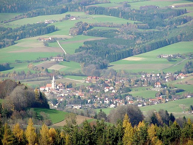
Zöbern is a charming village located in the state of Lower Austria, surrounded by beautiful landscapes, rolling hills, and diverse natural habitats. Hiking in and around Zöbern offers a great opportunity to explore the scenic beauty and tranquility of the region.
Hiking Trails
-
Local Trails: Zöbern has several well-marked hiking trails that vary in difficulty. Many of these trails take you through forests, past meadows, and along streams. The terrain can include gentle hills as well as more challenging sections for experienced hikers.
-
The Hiker's Path: One popular option is the "Hüttenrunde" or hut round, which connects various local huts and eateries, allowing hikers to enjoy local cuisine along their journey.
-
Nature Reserves: The surrounding area is rich in flora and fauna. Look for trails that lead to nearby nature reserves, where you can often see unique wildlife and plant species.
Recommended Tips
- Weather: Always check the local weather conditions before heading out as they can change quickly.
- Footwear: Wear sturdy, comfortable hiking boots to navigate the diverse terrain.
- Maps: Carry a detailed hiking map or use a GPS device or hiking app to stay on track, as some trails may not be well-marked.
- Hydration: Bring sufficient water, especially during the warmer months, and pack some snacks to keep your energy up.
- Local Customs: Respect nature and local guidelines, especially in more sensitive ecological areas.
Attractions Near Zöbern
- Historical Sites: Explore nearby historical sites or castles, which often offer stunning views from their elevated positions.
- Flora and Fauna: The area is known for its rich biodiversity, making it a great spot for nature lovers and bird watchers.
- Cultural Events: Check local calendars for any cultural events in and around Zöbern, which can provide a unique glimpse into the region's heritage.
Conclusion
Hiking in Zöbern allows for a peaceful escape into nature while experiencing the picturesque Austrian countryside. With its variety of trails and natural beauty, it’s a wonderful destination for both novice and experienced hikers. Enjoy your adventure!
- Страна:

- Почтовый код: 2851, 2852, 2870, 2871, 8244
- Телефонный код: 02642
- Код автомобильного номера: NK
- Координаты: 47° 30' 0" N, 16° 7' 0" E


- GPS треки (wikiloc): [Ссылка]
- Высота над уровнем моря: 591 м m
- Площадь: 31.56 кв.км
- Население: 1423
- Веб сайт: http://www.zoebern.at
- Википедия русская: wiki(ru)
- Википедия английская: wiki(en)
- Википедия национальная: wiki(de)
- Хранилище Wikidata: Wikidata: Q247656
- Катеория в википедии: [Ссылка]
- код Freebase: [/m/02r45sp]
- код GeoNames: Альт: [2760489]
- код VIAF: Альт: [243207151]
- код GND: Альт: [4765057-6]
- код австрийского муниципалитета: [31848]
Граничит с регионами:
Schäffern
Hiking in Schäffern
Schäffern, located in Austria, is a picturesque village that offers several beautiful hiking opportunities. The landscape around Schäffern is characterized by rolling hills, lush forests, and scenic views, making it a great destination for nature lovers and outdoor enthusiasts....
- Страна:
- Телефонный код: 03339
- Код автомобильного номера: HB
- Координаты: 47° 28' 39" N, 16° 6' 43" E
- GPS треки (wikiloc): [Ссылка]
- Высота над уровнем моря: 601 м m
- Площадь: 32.35 кв.км
- Население: 1374
- Веб сайт: [Ссылка]
Томасберг
Hiking in Томасберг
Thomasberg is a beautiful area for hiking, particularly known for its scenic views, diverse terrain, and the opportunity to connect with nature. Here are some key highlights and tips for hiking in this region:...
- Страна:
- Телефонный код: 02644
- Код автомобильного номера: NK
- Координаты: 47° 34' 0" N, 16° 8' 0" E
- GPS треки (wikiloc): [Ссылка]
- Высота над уровнем моря: 541 м m
- Площадь: 28.99 кв.км
- Население: 1284
- Веб сайт: [Ссылка]
Аспангберг-Санкт-Петер
- коммуна в Австрии
Hiking in Аспангберг-Санкт-Петер
Aspangberg-Sankt Peter, located in the Lower Austria region of Austria, is a fantastic destination for hiking enthusiasts. It offers a mix of stunning natural landscapes, picturesque villages, and a variety of trails suitable for different skill levels. Here are some highlights and tips for hiking in this area:...
- Страна:
- Телефонный код: 02642
- Код автомобильного номера: NK
- Координаты: 47° 33' 2" N, 16° 1' 9" E
- GPS треки (wikiloc): [Ссылка]
- Высота над уровнем моря: 490 м m
- Площадь: 81.49 кв.км
- Население: 1888
- Веб сайт: [Ссылка]
Мёнихкирхен
Hiking in Мёнихкирхен
Mönichkirchen is a charming village located in the Styrian region of Austria, known for its picturesque landscapes and accessible hiking trails. Nestled in the foothills of the Eastern Alps, Mönichkirchen offers a variety of hiking opportunities suitable for all levels of hikers....
- Страна:
- Почтовый код: 2872, 7421
- Телефонный код: 02649
- Код автомобильного номера: NK
- Координаты: 47° 30' 0" N, 16° 2' 0" E
- GPS треки (wikiloc): [Ссылка]
- Высота над уровнем моря: 967 м m
- Площадь: 16.31 кв.км
- Население: 606
- Веб сайт: [Ссылка]
Хохнойкирхен-Гшайдт
- коммуна в Австрии
Hiking in Хохнойкирхен-Гшайдт
Hochneukirchen-Gschaidt, located in Lower Austria, offers a beautiful setting for hiking enthusiasts with its picturesque landscapes, rolling hills, and diverse natural environments. Here are some highlights and tips for hiking in this area:...
- Страна:
- Почтовый код: 2852
- Телефонный код: 02648
- Код автомобильного номера: WB
- Координаты: 47° 27' 0" N, 16° 12' 0" E
- GPS треки (wikiloc): [Ссылка]
- Высота над уровнем моря: 769 м m
- Площадь: 35.13 кв.км
- Население: 1633
- Веб сайт: [Ссылка]
Крумбах
- община в Австрии, Нижняя Австрия, Винер-Нойштадт
Hiking in Крумбах
Krumbach, located in Lower Austria, offers a picturesque setting for hiking enthusiasts. The region is characterized by its rolling hills, lush forests, and open spaces, making it ideal for various types of hikes, from leisurely walks to more challenging trails....
- Страна:
- Телефонный код: 02647
- Код автомобильного номера: WB
- Координаты: 47° 31' 27" N, 16° 11' 31" E
- GPS треки (wikiloc): [Ссылка]
- Высота над уровнем моря: 533 м m
- Площадь: 43.91 кв.км
- Население: 2316
- Веб сайт: [Ссылка]