
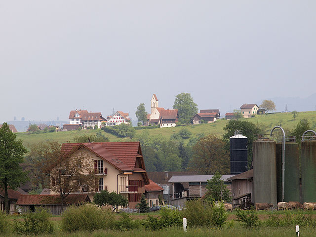
Цуг (Zug, Zug)

 Hiking in Цуг
Hiking in Zug, Switzerland, offers a wonderful blend of scenic beauty, varied terrain, and accessible trails, making it an ideal destination for both casual walkers and experienced hikers. Here are some key highlights about hiking in the area:
Scenic Landscapes
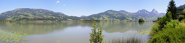
Zug is situated at the foot of the Swiss Alps and overlooks Lake Zug, providing stunning views throughout hikes. The combination of the lake, mountains, and lush greenery makes for a picturesque hiking experience.
Popular Hiking Trails
-
Zugerberg: This is a popular area for hiking, with trails that offer panoramic views of Lake Zug and the surrounding Alps. The Zugerberg can be accessed by a cable car for those who want a less strenuous start.
-
Rigi: Accessible from Zug, hiking on the Rigi, also known as the "Queen of the Mountains," offers various trails with incredible vistas. The Rigi is famous for its sunrise hikes and is easily reached via train or boat.
-
Natur- und Tierpark Goldingen: This nature park offers several trails through protected areas where hikers can enjoy not just the beautiful scenery but also wildlife spotting.
-
Zugersee Trails: There are several trails that circle Lake Zug, providing a leisurely experience with opportunities to picnic, swim, or visit charming villages along the way.
Trail Difficulty
The trails around Zug cater to all skill levels. You can find easy lakeside walks, moderate mountain trails, and challenging summit hikes. Always check local maps and trail markers for difficulty ratings.
Best Time to Hike
The ideal season for hiking in Zug is late spring through early autumn (May to October). In late spring and summer, the weather is generally pleasant, and the landscapes are lush. Autumn also provides beautiful foliage and clear skies, making for perfect hiking conditions.
Additional Tips
- Safety: Always carry enough water, snacks, and wear appropriate hiking gear. Keep an eye on the weather, as conditions can change rapidly in mountainous areas.
- Transportation: Zug is well-connected by public transport. Many trailheads can be accessed via train or bus, making it convenient for day hikes.
- Local Guidance: Consider joining a guided tour if you're new to hiking or unfamiliar with the area. Local guides can provide insights into the geography, flora, and fauna.
Overall, hiking in Zug is a fantastic experience that combines adventure, relaxation, and breathtaking alpine scenery. Enjoy your hike!
- Страна:

- Почтовый код: 6317; 6305; 6300; 6310; 6300–6305
- Телефонный код: 041
- Код автомобильного номера: ZG
- Координаты: 47° 10' 9" N, 8° 30' 59" E


- GPS треки (wikiloc): [Ссылка]
- Высота над уровнем моря: 611 м m
- Площадь: 21.61 кв.км
- Население: 30205
- Веб сайт: http://www.stadtzug.ch
- Википедия русская: wiki(ru)
- Википедия английская: wiki(en)
- Википедия национальная: wiki(de)
- Хранилище Wikidata: Wikidata: Q68144
- Галерея изображений в википедии: [Ссылка]
- Катеория в википедии: [Ссылка]
- код Freebase: [/m/0g1rd]
- код GeoNames: Альт: [7287644]
- ID отношения в OpenStreetMap: [1683151]
- код GND: Альт: [4068063-0]
- идентификатор местоположения ArchINFORM: [4389]
- код LCNAF: Альт: [n50061062]
- место в MusicBrainz: [cc42e606-7590-4cc3-bcab-ac494b740c62]
- код темы Quora: [Zug-Switzerland]
- код в энциклопедии «Британника онлайн»: [place/Zug-Switzerland]
- идентификатор HDS: [797]
- код швейцарского муниципалитета: [1711]
- код ISNI: Альт: [0000 0004 0531 3970]
- идентификатор Ringgold: [322811]
Граничит с регионами:


Майерскаппель
Hiking in Майерскаппель
Meierskappel is a picturesque village located in the canton of Lucerne, Switzerland, which offers a variety of hiking opportunities amidst beautiful landscapes. The area is characterized by its rolling hills, lush forests, and stunning views of the surrounding mountains and the nearby Lake Lucerne....
- Страна:
- Почтовый код: 6344
- Телефонный код: 041
- Код автомобильного номера: LU
- Координаты: 47° 7' 32" N, 8° 26' 39" E
- GPS треки (wikiloc): [Ссылка]
- Высота над уровнем моря: 487 м m
- Площадь: 9.23 кв.км
- Население: 1369
- Веб сайт: [Ссылка]

Бар
- город и коммуна в Швейцарии, в кантоне Цуг
Hiking in Бар
Baar, located in the canton of Zug in Switzerland, offers a variety of hiking opportunities that allow you to enjoy the stunning natural landscapes of the region. The area is characterized by rolling hills, lush forests, and beautiful views of the surrounding mountains and Lake Zug....
- Страна:
- Почтовый код: 6340
- Телефонный код: 041
- Код автомобильного номера: ZG
- Координаты: 47° 11' 44" N, 8° 31' 35" E
- GPS треки (wikiloc): [Ссылка]
- Высота над уровнем моря: 443 м m
- Площадь: 24.83 кв.км
- Население: 24322
- Веб сайт: [Ссылка]

Унтерегери
- коммуна в Швейцарии
Hiking in Унтерегери
Unterägeri is a picturesque municipality located in the Canton of Zug, Switzerland, surrounded by stunning landscapes and offering fantastic opportunities for hiking enthusiasts. Here are some highlights and points of interest for hiking in and around Unterägeri:...
- Страна:
- Почтовый код: 6314
- Телефонный код: 041
- Код автомобильного номера: ZG
- Координаты: 47° 7' 14" N, 8° 34' 40" E
- GPS треки (wikiloc): [Ссылка]
- Высота над уровнем моря: 763 м m
- Площадь: 26.7 кв.км
- Население: 8689
- Веб сайт: [Ссылка]
Хюненберг
Hiking in Хюненберг
Hünenberg, located in the Canton of Zug in Switzerland, offers a blend of beautiful landscapes, scenic views, and various hiking opportunities. Here are some key points to consider if you’re planning a hike in this area:...
- Страна:
- Почтовый код: 6331
- Телефонный код: 041
- Код автомобильного номера: ZG
- Координаты: 47° 11' 29" N, 8° 25' 11" E
- GPS треки (wikiloc): [Ссылка]
- Высота над уровнем моря: 403 м m
- Площадь: 18.7 кв.км
- Население: 8824
- Веб сайт: [Ссылка]

Вальхвиль
- коммуна в Швейцарии
Hiking in Вальхвиль
Walchwil is a picturesque village located in the Canton of Zug in Switzerland, situated on the shores of Lake Zug. It offers a range of hiking opportunities, making it an excellent destination for both casual walkers and seasoned hikers. Here are some highlights and tips for hiking in and around Walchwil:...
- Страна:
- Почтовый код: 6318
- Телефонный код: 041
- Код автомобильного номера: ZG
- Координаты: 47° 6' 31" N, 8° 31' 57" E
- GPS треки (wikiloc): [Ссылка]
- Высота над уровнем моря: 942 м m
- Площадь: 15.9 кв.км
- Население: 3617
- Веб сайт: [Ссылка]

Штайнхаузен
Hiking in Штайнхаузен
Steinhausen is a charming municipality located in the canton of Zug, Switzerland. Although it may not be as widely known for hiking as some of the larger mountainous regions, there are still opportunities in and around the area for enjoyable outdoor activities....
- Страна:
- Почтовый код: 6312
- Телефонный код: 041
- Код автомобильного номера: ZG
- Координаты: 47° 11' 49" N, 8° 29' 10" E
- GPS треки (wikiloc): [Ссылка]
- Высота над уровнем моря: 427 м m
- Площадь: 5.10 кв.км
- Население: 9875
- Веб сайт: [Ссылка]

Штайнерберг
- коммуна в Швейцарии
Hiking in Штайнерберг
Steinerberg, located in the beautiful region of Switzerland, offers an array of hiking opportunities for both beginners and experienced hikers. The area is renowned for its breathtaking landscapes, serene nature, and well-maintained trails....
- Страна:
- Почтовый код: 6416
- Телефонный код: 041
- Код автомобильного номера: SZ
- Координаты: 47° 4' 3" N, 8° 34' 52" E
- GPS треки (wikiloc): [Ссылка]
- Высота над уровнем моря: 937 м m
- Площадь: 6.9 кв.км
- Население: 954
- Веб сайт: [Ссылка]

Хам
- община в Швейцарии, Цуг
Hiking in Хам
Hiking in Cham, Switzerland, offers a beautiful blend of scenic views, diverse trails, and rich cultural experiences. Located in the Zug region, Cham lies along the shores of Lake Zug and is surrounded by stunning countryside and mountains. Here are some highlights and tips for hiking in this area:...
- Страна:
- Почтовый код: 6330
- Телефонный код: 041
- Код автомобильного номера: ZG
- Координаты: 47° 10' 49" N, 8° 27' 34" E
- GPS треки (wikiloc): [Ссылка]
- Высота над уровнем моря: 420 м m
- Площадь: 19.82 кв.км
- Население: 16690
- Веб сайт: [Ссылка]


Арт
Hiking in Арт
Arth, located in the Swiss Alps, offers stunning landscapes and a variety of hiking opportunities for outdoor enthusiasts. Here are some key points about hiking in the Arth region:...
- Страна:
- Почтовый код: 6415
- Телефонный код: 041
- Код автомобильного номера: SZ
- Координаты: 47° 3' 52" N, 8° 31' 27" E
- GPS треки (wikiloc): [Ссылка]
- Высота над уровнем моря: 422 м m
- Площадь: 48.50 кв.км
- Население: 11877
- Веб сайт: [Ссылка]